
FCCInfo.com
A Service of Cavell, Mertz & Associates, Inc.
(855) FCC-INFO
|
|
W23BW-D from 04/17/1989 W23BW-D from 01/04/1989 |
|
|
||||||||||||||||
|
|
Repacking Information: No changes Status: License Application Accepted: 07/06/2022 License Expires: 12/03/2029 File Number: -0000194534 FCC Website Links: LMS Facility Details This Application Other W23BW-D Applications Including Superseded Applications Mailing Address Correspondence for W23BW-D Correspondence related to application -0000194534 Service Contour - Open Street Map or USGS Map (51 dBu) Service Contour - KML / Google Earth (51 dBu) Public Inspection Files Rabbit Ears Info Search for W23BW-D Site Location: 43-03-09.0 N 89-28-42.0 W (NAD 83) Site Location: 43-03-09.0 N 89-28-41.6 W (Converted to NAD 27) ERP: 15 kW Polarization: Horizontally polarized Electrical Beam Tilt: 0.5 degrees R/C AGL: 91.5 m (300 ft.) R/C AMSL: 416.7 m (1367 ft.) Emission Mask: Full Service Site Elevation: 325.2 m. (1067 ft.) Height Overall*: 103.6 m (340 ft.) (* As Filed In This Application, may differ from ASR Data, Below.) Directional Antenna - Antenna Make/Model: Systems With Reliability Inc. LP16/23 Antenna ID: 1009739 Polarization: Horizontally polarized | ||||||||||||||||||
| Antenna Data for Antenna Id: 1009739 W23BW-D DC File: -0000194534 Systems With Reliability Inc. - LP16/23 Service: DC Standard Pattern: N Pattern and Field Values Include a 358° Clockwise Rotation | 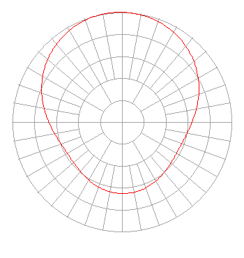 | ||||||||||||||||||
| Azimuth | Ratio | Azimuth | Ratio | Azimuth | Ratio | Azimuth | Ratio | ||||||||||||
| 8 | 0.993 | 18 | 0.976 | 28 | 0.949 | 38 | 0.911 | ||||||||||||
| 48 | 0.865 | 58 | 0.812 | 68 | 0.756 | 78 | 0.699 | ||||||||||||
| 88 | 0.648 | 98 | 0.608 | 108 | 0.582 | 118 | 0.573 | ||||||||||||
| 128 | 0.579 | 138 | 0.596 | 148 | 0.616 | 158 | 0.635 | ||||||||||||
| 168 | 0.648 | 178 | 0.651 | 188 | 0.646 | 198 | 0.632 | ||||||||||||
| 208 | 0.612 | 218 | 0.592 | 228 | 0.577 | 238 | 0.574 | ||||||||||||
| 248 | 0.586 | 258 | 0.615 | 268 | 0.658 | 278 | 0.710 | ||||||||||||
| 288 | 0.767 | 298 | 0.823 | 308 | 0.875 | 318 | 0.919 | ||||||||||||
| 328 | 0.955 | 338 | 0.981 | 348 | 0.996 | 358 | 1.000 | ||||||||||||
Structure Registration Number 1010214 Structure Type: TOWER Registered To: Madison TV License Company, LLC Structure Address: 5727 Tokay Blvd Madison, WI County Name: Dane County ASR Issued: 08/19/2021 Date Built: 10/15/1998 Site Elevation: 325.2 m (1067 ft.) Structure Height: 95 m (312 ft.) Height Overall: 103.6 m (340 ft.) Overall Height AMSL: 428.8 m (1407 ft.) FAA Determination: 09/10/1998 FAA Study #: 98-AGL-4005-OE FAA Circular #: 70/7460-1J Paint & Light FAA Chapters: 4, 8, 13 PRIOR FAA 64-CE-4 43-03-09.0 N 89-28-42.0 W (NAD 83) 43-03-09.0 N 89-28-41.6 W (Converted to NAD 27) |
295 Madison Avenue, 12th Floor New York, NY 10017 Phone: 954-606-5486 Corporation | Title: Vice President Of Regulatory Affairs Date: 07/06/2022 Application Certifier Hc2 Station Group, Inc. 295 Madison Avenue, 12th Floor New York, NY 10017 Applicant RENEE ILHARDT Hc2 Broadcasting Holdings, Inc. 295 Madison Avenue, 12th Floor New York, NY 10017 VP, REGULATORY AFFAIRS DAVID O'CONNOR Wilkinson, Barker, Knauer, Llp 1800 M Street Nw; Suite 800n Washington, DC 20036 PARTNER MICHAEL VOGE Hc2 Broadcasting Holdings, Inc. 295 Madison Avenue, 12th Floor New York, NY 10017 DIRECTOR OF ENGINEERING OPERATIONS | |||||||||||||||||