
FCCInfo.com
A Service of Cavell, Mertz & Associates, Inc.
(855) FCC-INFO
|
|
|
|
|
||||||||||||||||
|
|
Status: Construction Permit Application Accepted: 08/05/2022 NEW CP Expires: 09/13/2025 File Number: -0000195674 FCC Website Links: LMS Facility Details This Application Other NEW Applications Including Superseded Applications Mailing Address Correspondence for NEW Correspondence related to application -0000195674 Service Contour - Open Street Map or USGS Map (41 dBu) Service Contour - KML / Google Earth (41 dBu) Rabbit Ears Info Search for NEW Site Location: 45-46-29.8 N 89-14-55.5 W (NAD 83) Site Location: 45-46-30.0 N 89-14-55.0 W (Converted to NAD 27) ERP: 80 kW Polarization: Elliptically polarized HAAT: 161.5 m (530 ft.) Electrical Beam Tilt: 1.0 degree R/C AGL: 146.9 m (482 ft.) R/C AMSL: 659 m (2162 ft.) Site Elevation: 512.1 m. (1680 ft.) Height Overall*: 152.1 m (499 ft.) (* As Filed In This Application, may differ from ASR Data, Below.) Directional Antenna - Antenna Make/Model: Dielectric TFU-12DSB/VP-G Antenna ID: 1009838 Polarization: Elliptically polarized | ||||||||||||||||||
| Antenna Data for Antenna Id: 1009838 NEW DT File: -0000195674 Dielectric - TFU-12DSB/VP-G Service: DT Standard Pattern: N | 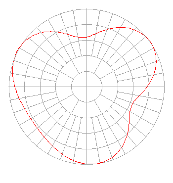 | ||||||||||||||||||
| Azimuth | Ratio | Azimuth | Ratio | Azimuth | Ratio | Azimuth | Ratio | ||||||||||||
| 0 | 0.634 | 10 | 0.688 | 20 | 0.780 | 30 | 0.877 | ||||||||||||
| 40 | 0.953 | 50 | 0.994 | 55 | 1.000 | 60 | 0.994 | ||||||||||||
| 70 | 0.953 | 80 | 0.877 | 90 | 0.780 | 100 | 0.688 | ||||||||||||
| 110 | 0.634 | 120 | 0.645 | 130 | 0.715 | 140 | 0.812 | ||||||||||||
| 150 | 0.903 | 160 | 0.967 | 170 | 0.997 | 173 | 1.000 | ||||||||||||
| 180 | 0.993 | 190 | 0.964 | 200 | 0.921 | 210 | 0.878 | ||||||||||||
| 220 | 0.845 | 230 | 0.827 | 240 | 0.827 | 250 | 0.845 | ||||||||||||
| 260 | 0.878 | 270 | 0.921 | 280 | 0.964 | 290 | 0.993 | ||||||||||||
| 297 | 1.000 | 300 | 0.997 | 310 | 0.967 | 320 | 0.903 | ||||||||||||
| 330 | 0.812 | 340 | 0.715 | 350 | 0.645 | ||||||||||||||
Structure Registration Number 1059095 Structure Type: TOWER Registered To: Gray Media Group, Inc. Structure Address: 6425 Thunder Lake Rd Rhinelander, WI County Name: Oneida County ASR Issued: 08/03/2021 Date Built: 12/21/2000 Site Elevation: 512.1 m (1680 ft.) Structure Height: 151 m (495 ft.) Height Overall: 152.1 m (499 ft.) Overall Height AMSL: 664.2 m (2179 ft.) FAA Determination: 05/25/2000 FAA Study #: 00-AGL-1161-OE FAA Circular #: 70/7460-1K Paint & Light FAA Chapters: 3, 4, 5, 12 PRIOR FAA 98-AGL-3556-OE 45-46-29.8 N 89-14-55.5 W (NAD 83) 45-46-30.0 N 89-14-55.0 W (Converted to NAD 27) |
4370 Peachtree Road, Ne Atlanta, GA 30319 Phone: 404-266-3888 Limited Liability Company | Title: Assistant Secretary Date: 08/05/2022 Application Certifier Gray Television Licensee, Llc 4370 Peachtree Road, Ne Atlanta, GA 30319 Applicant Joan Stewart Wiley Rein Llp 2050 M Street, Nw Washington, DC 20036 Joseph M. Davis, P.E. Chesapeake Rf Consultants, Llc 207 Old Dominion Road Yorktown, VA 23692 Consulting Engineer | |||||||||||||||||