
FCCInfo.com
A Service of Cavell, Mertz & Associates, Inc.
(855) FCC-INFO
|
|
WDMY-LD from 08/20/2017 WDMY-LD from 08/11/2005 WDMY-LD from 12/05/1990 |
|
|
||||||||||||||||
|
|
Status: Application Application Accepted: 02/12/2024 License Expires: 10/01/2021 File Number: -0000238722 FCC Website Links: LMS Facility Details This Application Other WDMY-LD Applications Including Superseded Applications Mailing Address Correspondence for WDMY-LD Correspondence related to application -0000238722 Service Contour - Open Street Map or USGS Map (43 dBu) Service Contour - KML / Google Earth (43 dBu) Rabbit Ears Info Search for WDMY-LD Site Location: 41-51-03.3 N 83-31-55.1 W (NAD 83) Site Location: 41-51-03.1 N 83-31-55.3 W (Converted to NAD 27) ERP: 2.2 kW Polarization: Horizontally polarized R/C AGL: 60 m (197 ft.) R/C AMSL: 252.3 m (828 ft.) Emission Mask: Full Service Site Elevation: 192.3 m. (631 ft.) Height Overall*: 82.3 m (270 ft.) (* As Filed In This Application, may differ from ASR Data, Below.) Directional Antenna - Antenna Make/Model: Scala HDCA-10 Antenna ID: 1011468 Polarization: Horizontally polarized
| ||||||||||||||||||
| Antenna Data for Antenna Id: 1011468 WDMY-LD LD File: -0000238722 Scala - HDCA-10 Service: LD Standard Pattern: N Pattern and Field Values Include a 20° Clockwise Rotation | 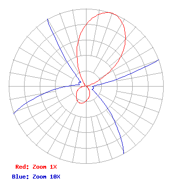 | ||||||||||||||||||
| Azimuth | Ratio | Azimuth | Ratio | Azimuth | Ratio | Azimuth | Ratio | ||||||||||||
| 0 | 0.792 | 10 | 0.937 | 20 | 1.000 | 30 | 0.937 | ||||||||||||
| 40 | 0.792 | 50 | 0.585 | 60 | 0.320 | 70 | 0.108 | ||||||||||||
| 80 | 0.030 | 90 | 0.010 | 100 | 0.010 | 110 | 0.010 | ||||||||||||
| 120 | 0.010 | 130 | 0.023 | 140 | 0.055 | 150 | 0.097 | ||||||||||||
| 160 | 0.133 | 170 | 0.162 | 180 | 0.192 | 190 | 0.222 | ||||||||||||
| 200 | 0.233 | 210 | 0.222 | 220 | 0.192 | 230 | 0.162 | ||||||||||||
| 240 | 0.133 | 250 | 0.097 | 260 | 0.055 | 270 | 0.023 | ||||||||||||
| 280 | 0.010 | 290 | 0.010 | 300 | 0.010 | 310 | 0.010 | ||||||||||||
| 320 | 0.030 | 330 | 0.108 | 340 | 0.320 | 350 | 0.585 | ||||||||||||
Structure Registration Number 1000531 Structure Type: TOWER Registered To: American Towers LLC Structure Address: 12900 Minx Road (ida #87811) Ida, MI County Name: Monroe County ASR Issued: 01/15/2013 Date Built: 09/02/1955 Site Elevation: 192.3 m (631 ft.) Structure Height: 78.3 m (257 ft.) Height Overall: 82.3 m (270 ft.) Overall Height AMSL: 274.6 m (901 ft.) FAA Determination: 06/24/2002 FAA Study #: 2002-AGL-2786-OE Paint & Light FAA Chapters: A1, H, 3, 11, 21, 23 OM&L TO REMAIN A MED-DUAL SYSTEM AS PER PRIOR STUDY 1993-AGL-3118-OE 41-51-03.3 N 83-31-55.1 W (NAD 83) 41-51-03.1 N 83-31-55.3 W (Converted to NAD 27) |
3434 W Kilbourn Ave. Milwaukee, WI 53208 Phone: 414-935-3000 Not-for-Profit | Title: Vice President Of Communications Date: 02/12/2024 Application Certifier Vcy America, Inc. 3434 W Kilbourn Ave. Milwaukee, WI 53208 Applicant Kathryne Dickerson, Esq Wiley Rein Llp 2050 M Street, N.w. Washington, DC 20036 Erik C Swanson, PE Hatfield & Dawson 9500 Greenwood Ave N Seattle, WA 98103 Consulting Engineer Robert H Branch, Jr Ctm 440 Astillero Street Las Vegas, NV 89138 Technical Consultant | |||||||||||||||||