
FCCInfo.com
A Service of Cavell, Mertz & Associates, Inc.
(855) FCC-INFO
|
|
WSHM-LD from 10/21/2003 WSHM-LD from 06/23/1994 WSHM-LD from 01/22/1988 |
|
|
||||||||||||||||||||||
|
|
Status: License Application Accepted: 09/30/2022 License Expires: 04/03/2023 File Number: -0000201476 FCC Website Links: LMS Facility Details This Application Other WSHM-LD Applications Including Superseded Applications Mailing Address Correspondence for WSHM-LD Correspondence related to application -0000201476 Service Contour - Open Street Map or USGS Map (51 dBu) Service Contour - KML / Google Earth (51 dBu) Rabbit Ears Info Search for WSHM-LD Site Location: 42-14-30.0 N 72-38-55.0 W (NAD 83) Site Location: 42-14-29.7 N 72-38-56.7 W (Converted to NAD 27) ERP: 4.9 kW Polarization: Horizontally polarized Electrical Beam Tilt: 1.05 degrees R/C AGL: 36.6 m (120 ft.) R/C AMSL: 402.4 m (1320 ft.) Emission Mask: Full Service Site Elevation: 365.8 m. (1200 ft.) Height Overall*: 59.6 m (196 ft.) (* As Filed In This Application, may differ from ASR Data, Below.) Directional Antenna - Antenna Make/Model: Dielectric TFU-8WB-1-R C160 Antenna ID: 1009523 Polarization: Horizontally polarized | ||||||||||||||||||||||||
| Antenna Data for Antenna Id: 1009523 WSHM-LD LD File: -0000201476 Dielectric - TFU-8WB-1-R C160 Service: LD Standard Pattern: N Pattern and Field Values Include a 180° Clockwise Rotation | 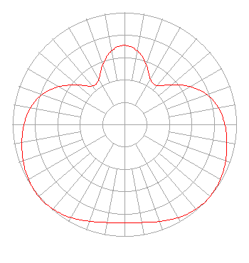 | ||||||||||||||||||||||||
| Azimuth | Ratio | Azimuth | Ratio | Azimuth | Ratio | Azimuth | Ratio | ||||||||||||||||||
| 0 | 0.706 | 10 | 0.666 | 20 | 0.566 | 30 | 0.463 | ||||||||||||||||||
| 40 | 0.452 | 50 | 0.549 | 60 | 0.677 | 70 | 0.782 | ||||||||||||||||||
| 80 | 0.851 | 90 | 0.895 | 100 | 0.928 | 110 | 0.960 | ||||||||||||||||||
| 120 | 0.987 | 130 | 0.999 | 140 | 0.990 | 150 | 0.961 | ||||||||||||||||||
| 160 | 0.922 | 170 | 0.890 | 180 | 0.878 | 190 | 0.890 | ||||||||||||||||||
| 200 | 0.921 | 210 | 0.960 | 220 | 0.990 | 230 | 1.000 | ||||||||||||||||||
| 240 | 0.989 | 250 | 0.962 | 260 | 0.930 | 270 | 0.896 | ||||||||||||||||||
| 280 | 0.851 | 290 | 0.781 | 300 | 0.675 | 310 | 0.546 | ||||||||||||||||||
| 320 | 0.448 | 330 | 0.460 | 340 | 0.564 | 350 | 0.666 | ||||||||||||||||||
Structure Registration Number 1018460 Structure Type: TOWER Registered To: SBA Infrastructures, LLC Structure Address: Atop Mount Tom Holyoke, MA County Name: Hampden County ASR Issued: 09/22/2008 Date Built: 09/01/1987 Site Elevation: 365.8 m (1200 ft.) Structure Height: 45.7 m (150 ft.) Height Overall: 59.6 m (196 ft.) Overall Height AMSL: 425.4 m (1396 ft.) FAA Determination: 02/21/1997 FAA Study #: 96-ANE-0559-OE Paint & Light FAA Chapters: NONE Removed expiration date from determination. Scenario 1./jjs/case#635066 42-14-30.0 N 72-38-55.0 W (NAD 83) 42-14-29.7 N 72-38-56.7 W (Converted to NAD 27) |
4370 Peachtree Road, Ne Atlanta, GA 30319 Phone: 404-266-8333 Limited Liability Company | Title: Assistant Secretary Date: 09/30/2022 Application Certifier Gray Television Licensee, Llc 4370 Peachtree Road, Ne Atlanta, GA 30319 Applicant Joseph M. Davis, P.E. Chesapeake Rf Consultants, Llc 207 Old Dominion Road Yorktown, VA 23692 Consulting Engineer Joan Stewart Wiley Rein Llp 2050 M Street, Nw Washington, DC 20036 | |||||||||||||||||||||||
|
| ||||||||||||||||||||||||