
FCCInfo.com
A Service of Cavell, Mertz & Associates, Inc.
(855) FCC-INFO
|
|
KDVR from 09/25/1981 KDVR from 06/08/1981 |
Post-repack Channel 36 Virtual Channel 31 |  |
|
|||||||||||||||||||||||||||||||||||||||||||||||||||||||||||||||||||||||||||||||||||||||||||||||||||||||||||||||||||
|
|
Repacking Information: Pre-Repack Channel: 32 Post-Repack Channel: 36 Post-Repack ERP: 1000 kW Phase: 9 Completion Deadline: 5/1/2020 Upstream/Downstream Dependencies Other Linked Stations Find nearby TV Facilities Status: License Application Accepted: 07/25/2023 License Expires: 04/01/2022 File Number: -0000218447 FCC Website Links: LMS Facility Details This Application Other KDVR Applications Including Superseded Applications Mailing Address Correspondence for KDVR Correspondence related to application -0000218447 Service Contour - Open Street Map or USGS Map (41 dBu) Service Contour - KML / Google Earth (41 dBu) Public Inspection Files History Cards for KDVR Rabbit Ears Info Search for KDVR Site Location: 39-43-42.1 N 105-14-15.7 W (NAD 83) Site Location: 39-43-42.1 N 105-14-13.7 W (Converted to NAD 27) ERP: 726 kW Polarization: Horizontally polarized HAAT: 261 m (856 ft.) Electrical Beam Tilt: 0.55 degrees R/C AGL: 50.9 m (167 ft.) R/C AMSL: 2293.6 m (7525 ft.) Site Elevation: 2242.7 m. (7358 ft.) Height Overall*: 114.3 m (375 ft.) (* As Filed In This Application, may differ from ASR Data, Below.) Directional Antenna - Antenna Make/Model: DIELECTRIC TFU-16WB-1-R C160 Antenna ID: 1006704 Polarization: Horizontally polarized
| ||||||||||||||||||||||||||||||||||||||||||||||||||||||||||||||||||||||||||||||||||||||||||||||||||||||||||||||||||||||
| Antenna Data for Antenna Id: 1006704 KDVR DX File: -0000218447 DIELECTRIC - TFU-16WB-1-R C160 Service: DX Standard Pattern: Y Pattern and Field Values Include a 85° Clockwise Rotation | 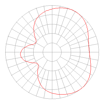 | ||||||||||||||||||||||||||||||||||||||||||||||||||||||||||||||||||||||||||||||||||||||||||||||||||||||||||||||||||||||
| Azimuth | Ratio | Azimuth | Ratio | Azimuth | Ratio | Azimuth | Ratio | ||||||||||||||||||||||||||||||||||||||||||||||||||||||||||||||||||||||||||||||||||||||||||||||||||||||||||||||||
| 5 | 0.937 | 15 | 0.972 | 25 | 0.996 | 35 | 0.995 | ||||||||||||||||||||||||||||||||||||||||||||||||||||||||||||||||||||||||||||||||||||||||||||||||||||||||||||||||
| 45 | 0.966 | 55 | 0.913 | 65 | 0.854 | 75 | 0.809 | ||||||||||||||||||||||||||||||||||||||||||||||||||||||||||||||||||||||||||||||||||||||||||||||||||||||||||||||||
| 85 | 0.792 | 95 | 0.809 | 105 | 0.853 | 115 | 0.911 | ||||||||||||||||||||||||||||||||||||||||||||||||||||||||||||||||||||||||||||||||||||||||||||||||||||||||||||||||
| 125 | 0.964 | 135 | 0.995 | 140 | 1.000 | 145 | 0.997 | ||||||||||||||||||||||||||||||||||||||||||||||||||||||||||||||||||||||||||||||||||||||||||||||||||||||||||||||||
| 155 | 0.974 | 165 | 0.938 | 175 | 0.898 | 185 | 0.851 | ||||||||||||||||||||||||||||||||||||||||||||||||||||||||||||||||||||||||||||||||||||||||||||||||||||||||||||||||
| 195 | 0.780 | 205 | 0.672 | 215 | 0.533 | 225 | 0.413 | ||||||||||||||||||||||||||||||||||||||||||||||||||||||||||||||||||||||||||||||||||||||||||||||||||||||||||||||||
| 235 | 0.411 | 245 | 0.521 | 255 | 0.632 | 265 | 0.677 | ||||||||||||||||||||||||||||||||||||||||||||||||||||||||||||||||||||||||||||||||||||||||||||||||||||||||||||||||
| 275 | 0.634 | 285 | 0.523 | 295 | 0.414 | 305 | 0.416 | ||||||||||||||||||||||||||||||||||||||||||||||||||||||||||||||||||||||||||||||||||||||||||||||||||||||||||||||||
| 315 | 0.534 | 325 | 0.673 | 335 | 0.781 | 345 | 0.851 | ||||||||||||||||||||||||||||||||||||||||||||||||||||||||||||||||||||||||||||||||||||||||||||||||||||||||||||||||
| 355 | 0.898 | ||||||||||||||||||||||||||||||||||||||||||||||||||||||||||||||||||||||||||||||||||||||||||||||||||||||||||||||||||||||
Structure Registration Number 1022259 Structure Type: LTOWER Registered To: Tribune Broadcasting Company II LLC Structure Address: 21214 Cedar Lake Rd Golden, CO County Name: Jefferson County ASR Issued: 01/16/2020 Date Built: 05/06/2014 Site Elevation: 2242.7 m (7358 ft.) Structure Height: 113.4 m (372 ft.) Height Overall: 114.3 m (375 ft.) Overall Height AMSL: 2357 m (7733 ft.) FAA Determination: 04/16/2013 FAA Study #: 2013-ANM-511-OE FAA Circular #: 70/7460-1K Paint & Light FAA Chapters: 3, 4, 5, 12 39-43-42.1 N 105-14-15.7 W (NAD 83) 39-43-42.1 N 105-14-13.7 W (Converted to NAD 27) |
545 E. John Carpenter Freeway Dallas, TX 75062 Phone: 972-373-8000 Limited Liability Company | Title: Associate General Counsel Date: 07/25/2023 Application Certifier Tribune Broadcasting Company Ii Llc 545 E. John Carpenter Freeway Dallas, TX 75062 Applicant Louis R duTreil, Jr Dutreil Lundin & Rackley Inc 5212 Station Way Sarasota, FL 34233 Technical Consultant Jason Roberts Nexstar Media Inc. 545 E John Carpenter Freeway Irving, TX 75062 Associate General Counsel | |||||||||||||||||||||||||||||||||||||||||||||||||||||||||||||||||||||||||||||||||||||||||||||||||||||||||||||||||||||
| |||||||||||||||||||||||||||||||||||||||||||||||||||||||||||||||||||||||||||||||||||||||||||||||||||||||||||||||||||||||
