
FCCInfo.com
A Service of Cavell, Mertz & Associates, Inc.
(855) FCC-INFO
|
|
K23DT-D from 10/27/2009 K23DT-D from 06/29/1993 |
|
|
||||||||||||||||
|
|
Status: License Application Accepted: 02/10/2023 License Expires: 12/01/2022 File Number: -0000210635 FCC Website Links: LMS Facility Details This Application Other K34QQ-D Applications Including Superseded Applications Mailing Address Correspondence for K34QQ-D Correspondence related to application -0000210635 Service Contour - Open Street Map or USGS Map (51 dBu) Service Contour - KML / Google Earth (51 dBu) Rabbit Ears Info Search for K34QQ-D Site Location: 39-18-36.6 N 119-53-04.9 W (NAD 83) Site Location: 39-18-36.9 N 119-53-01.2 W (Converted to NAD 27) ERP: 3 kW Polarization: Circularly polarized R/C AGL: 16.3 m (53 ft.) R/C AMSL: 2964.9 m (9727 ft.) Emission Mask: Full Service Site Elevation: 2948.6 m. (9674 ft.) Height Overall*: 49.7 m (163 ft.) (* As Filed In This Application, may differ from ASR Data, Below.) Directional Antenna - Antenna Make/Model: Dielectric TUL-BP2-2/4M-1 Antenna ID: 1010365 Polarization: Circularly polarized
| ||||||||||||||||||
| Antenna Data for Antenna Id: 1010365 K34QQ-D LD File: -0000210635 Dielectric - TUL-BP2-2/4M-1 Service: LD Standard Pattern: N | 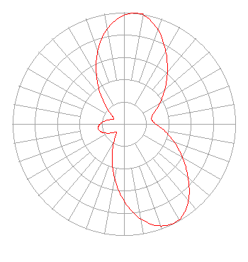 | ||||||||||||||||||
| Azimuth | Ratio | Azimuth | Ratio | Azimuth | Ratio | Azimuth | Ratio | ||||||||||||
| 0 | 0.973 | 8 | 1.000 | 10 | 0.991 | 20 | 0.897 | ||||||||||||
| 30 | 0.749 | 40 | 0.604 | 50 | 0.478 | 60 | 0.372 | ||||||||||||
| 70 | 0.284 | 80 | 0.250 | 90 | 0.284 | 100 | 0.372 | ||||||||||||
| 110 | 0.478 | 120 | 0.604 | 130 | 0.749 | 140 | 0.897 | ||||||||||||
| 150 | 0.991 | 160 | 0.973 | 170 | 0.865 | 180 | 0.690 | ||||||||||||
| 190 | 0.489 | 200 | 0.313 | 210 | 0.176 | 220 | 0.105 | ||||||||||||
| 230 | 0.119 | 240 | 0.167 | 250 | 0.213 | 260 | 0.235 | ||||||||||||
| 270 | 0.213 | 280 | 0.167 | 290 | 0.119 | 300 | 0.105 | ||||||||||||
| 310 | 0.176 | 320 | 0.313 | 330 | 0.489 | 340 | 0.690 | ||||||||||||
| 350 | 0.865 | ||||||||||||||||||
Structure Registration Number 1009892 Structure Type: LTOWER Registered To: American Towers LLC Structure Address: Off South R 27 Hwy Slide Mountain Carson City, NV County Name: Washoe County ASR Issued: 01/05/2021 Date Built: 01/01/1985 Site Elevation: 2948.6 m (9674 ft.) Structure Height: 49.4 m (162 ft.) Height Overall: 49.7 m (163 ft.) Overall Height AMSL: 2998.3 m (9837 ft.) FAA Determination: 02/05/2013 FAA Study #: 2013-AWP-495-OE Paint & Light FAA Chapters: NONE 39-18-36.6 N 119-53-04.9 W (NAD 83) 39-18-36.9 N 119-53-01.2 W (Converted to NAD 27) |
Avon, CO 81620 Phone: 435-649-0045 Limited Liability Company | Title: President Of Licensee's Sole Member Date: 02/10/2023 Application Certifier DEERFIELD MEDIA (RENO) LICENSEE, LLC Deerfield Media (reno) Licensee, Llc 1776 Park Ave. 4-135 Park City, UT 84060 Applicant Scott R. Flick, Esq Pillsbury Winthrop Shaw Pittman Llp 1200 Seventeenth Street, Nw Washington, DC 20036 Carl Gluck Carl T. Jones Corporation 7901 Yarnwood Court Springfield, VA 22153 | |||||||||||||||||