
FCCInfo.com
A Service of Cavell, Mertz & Associates, Inc.
(855) FCC-INFO
|
|
W15BU-D from 03/01/1999 |
|
|
||||||||||||||||
|
|
Repacking Information: No changes Status: License Application Accepted: 03/22/2023 License Expires: 12/03/2029 File Number: -0000212851 FCC Website Links: LMS Facility Details This Application Other W15BU-D Applications Including Superseded Applications Mailing Address Correspondence for W15BU-D Correspondence related to application -0000212851 Service Contour - Open Street Map or USGS Map (51 dBu) Service Contour - KML / Google Earth (51 dBu) Public Inspection Files Rabbit Ears Info Search for W15BU-D Site Location: 37-50-43.0 N 88-55-46.0 W (NAD 83) Site Location: 37-50-42.8 N 88-55-45.7 W (Converted to NAD 27) ERP: 15 kW Polarization: Horizontally polarized R/C AGL: 137 m (449 ft.) R/C AMSL: 272 m (892 ft.) Emission Mask: Stringent Site Elevation: 135 m. (443 ft.) Height Overall*: 152 m (499 ft.) (* As Filed In This Application, may differ from ASR Data, Below.) Directional Antenna - Antenna Make/Model: Jampro JA/SS-OMNIOID-16 Antenna ID: 90552 Polarization: Horizontally polarized | ||||||||||||||||||
| Antenna Data for Antenna Id: 90552 W15BU-D DC File: -0000212851 Jampro - JA/SS-OMNIOID-16 Service: DC Standard Pattern: Y Pattern and Field Values Include a 90° Clockwise Rotation | 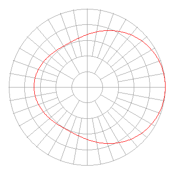 | ||||||||||||||||||
| Azimuth | Ratio | Azimuth | Ratio | Azimuth | Ratio | Azimuth | Ratio | ||||||||||||
| 0 | 0.668 | 10 | 0.715 | 20 | 0.767 | 30 | 0.820 | ||||||||||||
| 40 | 0.871 | 50 | 0.915 | 60 | 0.951 | 70 | 0.978 | ||||||||||||
| 80 | 0.994 | 90 | 1.000 | 100 | 0.994 | 110 | 0.978 | ||||||||||||
| 120 | 0.951 | 130 | 0.915 | 140 | 0.871 | 150 | 0.820 | ||||||||||||
| 160 | 0.767 | 170 | 0.715 | 180 | 0.668 | 190 | 0.631 | ||||||||||||
| 200 | 0.609 | 210 | 0.602 | 220 | 0.608 | 230 | 0.623 | ||||||||||||
| 240 | 0.642 | 250 | 0.659 | 260 | 0.672 | 270 | 0.676 | ||||||||||||
| 280 | 0.672 | 290 | 0.659 | 300 | 0.642 | 310 | 0.623 | ||||||||||||
| 320 | 0.608 | 330 | 0.602 | 340 | 0.609 | 350 | 0.631 | ||||||||||||
Structure Registration Number 1059897 Structure Type: TOWER Registered To: THREE ANGELS BROADCASTING NETWORK INC Structure Address: 0.3 Km E Of Sr 37 At Ill Central Rr Crossing Johnston City, IL County Name: Williamson County ASR Issued: 01/29/1999 Date Built: 01/01/1991 Site Elevation: 135 m (443 ft.) Structure Height: 152 m (499 ft.) Height Overall: 152 m (499 ft.) Overall Height AMSL: 287 m (942 ft.) FAA Determination: 08/22/1990 FAA Study #: 90-AGL-1374-OE FAA Circular #: 70/7460-1G Paint & Light FAA Chapters: 3, 4, 5, 9 Removed expiration date from determination. Scenario 1./jjs/case#635066 37-50-43.0 N 88-55-46.0 W (NAD 83) 37-50-42.8 N 88-55-45.7 W (Converted to NAD 27) |
3391 Charley Good Road West Frankfort, IL 62896 Phone: 618-627-4651 Not-for-Profit | Title: President Date: 03/22/2023 Application Certifier THREE ANGELS BROADCASTING NETWORK, INC. Three Angels Broadcasting Network, Inc. 3391 Charley Good Road West Frankfort, IL 62896 Applicant DANIEL N. PEEK 3abn 3391 Charley Good Road West Frankfort, IL 62896 ENGINEER MOSES PRIMO 3abn 3391 Charley Good Road West Frankfort, IL 62896 DIRECTOR OF BROADCASTING OPERATIONS AND ENGINEERING | |||||||||||||||||