
FCCInfo.com
A Service of Cavell, Mertz & Associates, Inc.
(855) FCC-INFO
|
|
KQAF-LD from 10/06/1993 |
|
|
||||||||||||||||
|
|
Status: Construction Permit Application Accepted: 04/03/2023 KQAF-LD CP Expires: 04/06/2026 File Number: -0000213353 FCC Website Links: LMS Facility Details This Application Other KQAF-LD Applications Including Superseded Applications Mailing Address Correspondence for KQAF-LD Correspondence related to application -0000213353 Service Contour - Open Street Map or USGS Map (51 dBu) Service Contour - KML / Google Earth (51 dBu) Rabbit Ears Info Search for KQAF-LD Site Location: 38-16-48.4 N 104-33-10.9 W (NAD 83) Site Location: 38-16-48.4 N 104-33-09.0 W (Converted to NAD 27) ERP: 10 kW Polarization: Horizontally polarized R/C AGL: 39.6 m (130 ft.) R/C AMSL: 1472.4 m (4831 ft.) Emission Mask: Full Service Site Elevation: 1432.8 m. (4701 ft.) Height Overall*: 54.9 m (180 ft.) (* As Filed In This Application, may differ from ASR Data, Below.) Directional Antenna - Antenna Make/Model: Kathrein 2X2 panel array Antenna ID: 1010605 Polarization: Horizontally polarized
| ||||||||||||||||||
| Antenna Data for Antenna Id: 1010605 KQAF-LD LD File: -0000213353 Kathrein - 2X2 panel array Service: LD Standard Pattern: N Pattern and Field Values Include a 250° Clockwise Rotation | 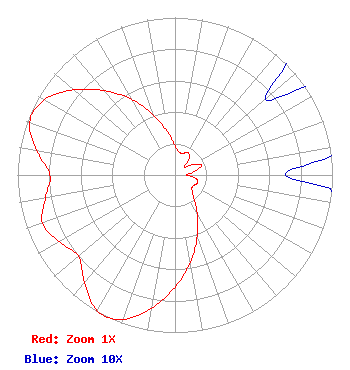 | ||||||||||||||||||
| Azimuth | Ratio | Azimuth | Ratio | Azimuth | Ratio | Azimuth | Ratio | ||||||||||||
| 0 | 0.187 | 10 | 0.148 | 20 | 0.145 | 30 | 0.165 | ||||||||||||
| 40 | 0.141 | 50 | 0.075 | 60 | 0.129 | 70 | 0.178 | ||||||||||||
| 80 | 0.121 | 90 | 0.070 | 100 | 0.136 | 110 | 0.151 | ||||||||||||
| 120 | 0.135 | 130 | 0.140 | 140 | 0.184 | 150 | 0.281 | ||||||||||||
| 160 | 0.414 | 170 | 0.561 | 180 | 0.713 | 190 | 0.859 | ||||||||||||
| 200 | 0.975 | 206 | 1.000 | 210 | 0.992 | 220 | 0.893 | ||||||||||||
| 230 | 0.801 | 240 | 0.849 | 250 | 0.895 | 260 | 0.835 | ||||||||||||
| 270 | 0.794 | 280 | 0.890 | 290 | 0.983 | 300 | 0.958 | ||||||||||||
| 310 | 0.841 | 320 | 0.698 | 330 | 0.556 | 340 | 0.405 | ||||||||||||
| 350 | 0.278 | ||||||||||||||||||
Structure Registration Number 1290412 Structure Type: LTOWER Registered To: Industrial Tower and Wireless, LLC Structure Address: E 11th Street & Gary Ave Pueblo, CO County Name: Pueblo County ASR Issued: 02/03/2014 Date Built: 01/23/2015 Site Elevation: 1432.8 m (4701 ft.) Structure Height: 54.9 m (180 ft.) Height Overall: 54.9 m (180 ft.) Overall Height AMSL: 1487.7 m (4881 ft.) FAA Determination: 08/15/2013 FAA Study #: 2013-ANM-1713-OE Paint & Light FAA Chapters: NONE Removed expiration date from determination. Scenario 1./jjs/case#635066 38-16-48.4 N 104-33-10.9 W (NAD 83) 38-16-48.4 N 104-33-09.0 W (Converted to NAD 27) |
Po Box 1471 29833 Ruby Ranch Road Evergreen, CO 80439 Phone: 907-227-9195 Limited Liability Company | Title: Manager Date: 04/03/2023 Application Certifier Denver Digital Television, Llc Po Box 1471 29833 Ruby Ranch Road Evergreen, CO 80439 Applicant James Talens James Talens 6017 Woodley Rd 29833 Ruby Ranch Road Mclean, VA 22101 Attorney Erik C Swanson, PE Hatfield & Dawson 9500 Greenwood Ave N Seattle, WA 98103 Consulting Engineer | |||||||||||||||||