
FCCInfo.com
A Service of Cavell, Mertz & Associates, Inc.
(855) FCC-INFO
|
|
|
|
|
||||||||||||||||
|
|
Status: License Application Accepted: 04/05/2023 License Expires: 02/01/2029 File Number: -0000213553 FCC Website Links: LMS Facility Details This Application Other W17EM-D Applications Including Superseded Applications Mailing Address Correspondence for W17EM-D Correspondence related to application -0000213553 Service Contour - Open Street Map or USGS Map (51 dBu) Service Contour - KML / Google Earth (51 dBu) Rabbit Ears Info Search for W17EM-D Site Location: 30-26-00.0 N 85-24-51.0 W (NAD 83) Site Location: 30-25-59.3 N 85-24-51.3 W (Converted to NAD 27) ERP: 0.2 kW Polarization: Horizontally polarized R/C AGL: 15 m (49 ft.) R/C AMSL: 57.1 m (187 ft.) Emission Mask: Simple Site Elevation: 42.1 m. (138 ft.) Height Overall*: 247.5 m (812 ft.) (* As Filed In This Application, may differ from ASR Data, Below.) Directional Antenna - Antenna Make/Model: Sam SAMCO160 Antenna ID: 1009817 Polarization: Horizontally polarized | ||||||||||||||||||
| Antenna Data for Antenna Id: 1009817 W17EM-D LD File: -0000213553 Sam - SAMCO160 Service: LD Standard Pattern: Y Pattern and Field Values Include a 225° Clockwise Rotation | 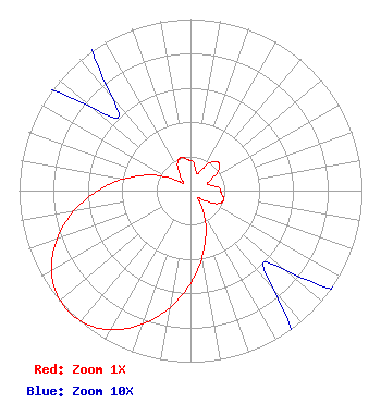 | ||||||||||||||||||
| Azimuth | Ratio | Azimuth | Ratio | Azimuth | Ratio | Azimuth | Ratio | ||||||||||||
| 5 | 0.170 | 15 | 0.120 | 25 | 0.110 | 35 | 0.200 | ||||||||||||
| 45 | 0.230 | 55 | 0.200 | 65 | 0.110 | 75 | 0.120 | ||||||||||||
| 85 | 0.170 | 95 | 0.180 | 105 | 0.200 | 115 | 0.180 | ||||||||||||
| 125 | 0.100 | 135 | 0.060 | 145 | 0.108 | 155 | 0.208 | ||||||||||||
| 165 | 0.325 | 175 | 0.465 | 185 | 0.617 | 195 | 0.764 | ||||||||||||
| 205 | 0.888 | 215 | 0.973 | 225 | 1.000 | 235 | 0.973 | ||||||||||||
| 245 | 0.888 | 255 | 0.764 | 265 | 0.617 | 275 | 0.465 | ||||||||||||
| 285 | 0.325 | 295 | 0.208 | 305 | 0.108 | 315 | 0.060 | ||||||||||||
| 325 | 0.100 | 335 | 0.180 | 345 | 0.200 | 355 | 0.180 | ||||||||||||
Structure Registration Number 1029017 Structure Type: GTOWER Registered To: Gray Media Group, Inc. Structure Address: 12544 Highway 20 Youngstown, FL County Name: Bay County ASR Issued: 09/09/2020 Date Built: 01/01/1962 Site Elevation: 42.1 m (138 ft.) Structure Height: 247.5 m (812 ft.) Height Overall: 247.5 m (812 ft.) Overall Height AMSL: 289.6 m (950 ft.) FAA Determination: 03/07/2018 FAA Study #: 2018-ASO-3400-OE FAA Circular #: 70/7460-1L Paint & Light FAA Chapters: 4, 7, 12 Removed expiration date from determination. Scenario 1./jjs/case#635066 30-26-00.0 N 85-24-51.0 W (NAD 83) 30-25-59.3 N 85-24-51.3 W (Converted to NAD 27) |
9925 Haynes Bridge Rd Suite 200-155 Alphretta, GA 30022 Phone: 470-413-1820 Limited Liability Company | Title: Member/manager Date: 04/05/2023 Application Certifier Castelli Media Llc 5174 Mcginnis Ferry Road Suite 133 Alphretta, GA 30005 Applicant Susan Hansen B. W. St. Clair 2305 Vida Shaw Road New Iberia, LA 70563 CONSULTANT | |||||||||||||||||