
FCCInfo.com
A Service of Cavell, Mertz & Associates, Inc.
(855) FCC-INFO
|
|
|
|
|
||||||||||||||||
|
|
Status: License Application Accepted: 05/23/2023 License Expires: 08/01/2029 File Number: -0000215069 FCC Website Links: LMS Facility Details This Application Other W14EE-D Applications Including Superseded Applications Mailing Address Correspondence for W14EE-D Correspondence related to application -0000215069 Service Contour - Open Street Map or USGS Map (51 dBu) Service Contour - KML / Google Earth (51 dBu) Rabbit Ears Info Search for W14EE-D Site Location: 36-11-32.9 N 85-25-23.3 W (NAD 83) Site Location: 36-11-32.7 N 85-25-23.4 W (Converted to NAD 27) ERP: 15 kW Polarization: Elliptically polarized Electrical Beam Tilt: 0.5 degrees R/C AGL: 64 m (210 ft.) R/C AMSL: 505.4 m (1658 ft.) Emission Mask: Full Service Site Elevation: 441.4 m. (1448 ft.) Height Overall*: 74.1 m (243 ft.) (* As Filed In This Application, may differ from ASR Data, Below.) Directional Antenna - Antenna Make/Model: Dielectric TLP-8H/VP Antenna ID: 1010735 Polarization: Elliptically polarized | ||||||||||||||||||
| Antenna Data for Antenna Id: 1010735 W14EE-D LD File: -0000215069 Dielectric - TLP-8H/VP Service: LD Standard Pattern: N Pattern and Field Values Include a 300° Clockwise Rotation | 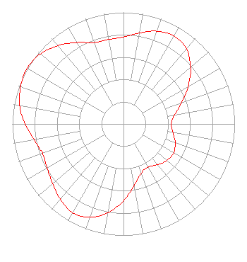 | ||||||||||||||||||
| Azimuth | Ratio | Azimuth | Ratio | Azimuth | Ratio | Azimuth | Ratio | ||||||||||||
| 0 | 0.779 | 10 | 0.828 | 20 | 0.885 | 30 | 0.911 | ||||||||||||
| 40 | 0.880 | 50 | 0.788 | 60 | 0.673 | 70 | 0.560 | ||||||||||||
| 80 | 0.467 | 90 | 0.430 | 100 | 0.452 | 110 | 0.495 | ||||||||||||
| 120 | 0.521 | 130 | 0.511 | 140 | 0.477 | 150 | 0.446 | ||||||||||||
| 160 | 0.468 | 170 | 0.560 | 180 | 0.688 | 190 | 0.810 | ||||||||||||
| 200 | 0.891 | 210 | 0.918 | 220 | 0.885 | 230 | 0.834 | ||||||||||||
| 240 | 0.793 | 250 | 0.777 | 260 | 0.816 | 270 | 0.885 | ||||||||||||
| 280 | 0.949 | 290 | 0.984 | 300 | 1.000 | 310 | 0.977 | ||||||||||||
| 320 | 0.917 | 330 | 0.842 | 340 | 0.776 | 350 | 0.768 | ||||||||||||
Structure Registration Number 1043477 Structure Type: Registered To: American Towers LLC Structure Address: 4660 Brotherton Mountain Rd (#88707) Cookeville, TN County Name: Putnam County ASR Issued: 06/21/2016 Date Built: 12/14/2009 Site Elevation: 441.4 m (1448 ft.) Structure Height: 67.7 m (222 ft.) Height Overall: 74.1 m (243 ft.) Overall Height AMSL: 515.5 m (1691 ft.) FAA Determination: 04/08/2010 FAA Study #: 2010-ASO-1003-OE FAA Circular #: 70/7460-1K Paint & Light FAA Chapters: 4, 8, 12 OM&L to remain the same as prior studies = A MED-DUAL SYSTEM 36-11-32.9 N 85-25-23.3 W (NAD 83) 36-11-32.7 N 85-25-23.4 W (Converted to NAD 27) |
4370 Peachtree Road, Ne Atlanta, GA 30319 Phone: 404-504-9828 Limited Liability Company | Title: Assistant Secretary Date: 05/23/2023 Application Certifier Gray Television Licensee, Llc 4370 Peachtree Road, Ne Atlanta, GA 30319 Applicant Joseph M. Davis, P.E. Chesapeake Rf Consultants, Llc 207 Old Dominion Rd Yorktown, VA 23692 Consulting Engineer Joan Stewart Wiley Rein Llp 2050 M Street, Nw Washington, DC 20036 | |||||||||||||||||