
FCCInfo.com
A Service of Cavell, Mertz & Associates, Inc.
(855) FCC-INFO
|
|
KMCC from 02/07/1997 |
Virtual Channel 34 |
|
||||||||||||||||
|
|
Repacking Information: No changes Status: License Application Accepted: 06/05/2023 License Expires: 10/01/2030 File Number: -0000216254 FCC Website Links: LMS Facility Details This Application Other KMCC Applications Including Superseded Applications Mailing Address Correspondence for KMCC Correspondence related to application -0000216254 Service Contour - Open Street Map or USGS Map (41 dBu) Service Contour - KML / Google Earth (41 dBu) Public Inspection Files Rabbit Ears Info Search for KMCC DTS Site Number: 1 Site Location: 35-39-07.0 N 114-18-43.8 W (NAD 83) Site Location: 35-39-07.0 N 114-18-40.9 W (Converted to NAD 27) ERP: 1000 kW Polarization: Horizontally polarized HAAT: 607 m (1991 ft.) Electrical Beam Tilt: 1 degree R/C AGL: 363 m (1191 ft.) R/C AMSL: 1648 m (5407 ft.) Site Elevation: 1285 m. (4216 ft.) Height Overall*: 413 m (1355 ft.) (* As Filed In This Application, may differ from ASR Data, Below.) Directional Antenna - Antenna Make/Model: DIELECTRIC TFU-30DSCS180 Antenna ID: 113077 Polarization: Horizontally polarized | ||||||||||||||||||
| Antenna Data for Antenna Id: 113077 KMCC DD File: -0000216254 DIELECTRIC - TFU-30DSCS180 Service: DD Standard Pattern: Y | 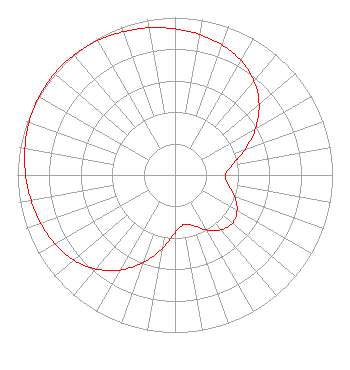 | ||||||||||||||||||
| Azimuth | Ratio | Azimuth | Ratio | Azimuth | Ratio | Azimuth | Ratio | ||||||||||||
| 0 | 0.928 | 10 | 0.906 | 20 | 0.878 | 30 | 0.839 | ||||||||||||
| 40 | 0.780 | 50 | 0.697 | 60 | 0.591 | 70 | 0.474 | ||||||||||||
| 80 | 0.369 | 90 | 0.319 | 100 | 0.343 | 110 | 0.403 | ||||||||||||
| 120 | 0.455 | 130 | 0.475 | 140 | 0.455 | 150 | 0.403 | ||||||||||||
| 160 | 0.343 | 170 | 0.319 | 180 | 0.369 | 190 | 0.474 | ||||||||||||
| 200 | 0.591 | 210 | 0.697 | 220 | 0.780 | 230 | 0.839 | ||||||||||||
| 240 | 0.878 | 250 | 0.906 | 260 | 0.928 | 270 | 0.949 | ||||||||||||
| 280 | 0.968 | 290 | 0.985 | 300 | 0.996 | 310 | 1.000 | ||||||||||||
| 320 | 0.996 | 330 | 0.985 | 340 | 0.968 | 350 | 0.949 | ||||||||||||
Structure Registration Number 1211383 Structure Type: GTOWER Registered To: American Towers LLC Structure Address: 8125 W. 19th Street (atc Site # 370261) Dolan Springs, AZ County Name: Mohave County ASR Issued: 11/18/2016 Date Built: 09/21/2006 Site Elevation: 1285 m (4216 ft.) Structure Height: 412.1 m (1352 ft.) Height Overall: 413 m (1355 ft.) Overall Height AMSL: 1698 m (5571 ft.) FAA Determination: 11/03/2016 FAA Study #: 2016-AWP-9238-OE FAA Circular #: 70/7460-1L Paint & Light FAA Chapters: 4, 9, 12 PRIOR STUDY 2016-AWP-1144-OE 35-39-07.0 N 114-18-43.8 W (NAD 83) 35-39-07.0 N 114-18-40.9 W (Converted to NAD 27) |
312 Walnut Street 28th Floor Cincinnati, OH 45202 Phone: 513-977-3000 Limited Liability Company | Title: Vp, Station Operations Date: 06/05/2023 Application Certifier ION TELEVISION LICENSE, LLC Ion Television License, Llc 312 Walnut Street 28th Floor Cincinnati, OH 45202 Applicant James Collins The E.w. Scripps Company 14444 66th Street North Clearwater, FL 33764 VP, Station Operations David Giles The E.w. Scripps Company 312 Walnut Street Cincinnati, OH 45202 SVP, Deputy General Counsel, Chief Ethics Officer | |||||||||||||||||