
FCCInfo.com
A Service of Cavell, Mertz & Associates, Inc.
(855) FCC-INFO
|
|
WFBD from 04/05/1996 |
Post-repack Channel 29 Virtual Channel 48 |
|
||||||||||||||||
|
|
Repacking Information: Pre-Repack Channel: 48 Post-Repack Channel: 29 Post-Repack ERP: 691 kW Phase: 7 Completion Deadline: 1/17/2020 Find nearby TV Facilities Status: Construction Permit Application Accepted: 10/17/2023 WFBD CP Expires: 10/21/2025 File Number: -0000216432 FCC Website Links: LMS Facility Details This Application Other WFBD Applications Including Superseded Applications Mailing Address Correspondence for WFBD Correspondence related to application -0000216432 Service Contour - Open Street Map or USGS Map (41 dBu) Service Contour - KML / Google Earth (41 dBu) Public Inspection Files Rabbit Ears Info Search for WFBD DTS Site Number: 2 Site Location: 30-36-41.0 N 87-36-26.4 W (NAD 83) Site Location: 30-36-40.3 N 87-36-26.5 W (Converted to NAD 27) ERP: 80 kW Polarization: Elliptically polarized HAAT: 191.6 m (629 ft.) Electrical Beam Tilt: 0.75 degrees R/C AGL: 200 m (656 ft.) R/C AMSL: 232.3 m (762 ft.) Site Elevation: 32.3 m. (106 ft.) Height Overall*: 577.3 m (1894 ft.) (* As Filed In This Application, may differ from ASR Data, Below.) Directional Antenna - Antenna Make/Model: Dielectric TUL-C1-6/6M-1-K Antenna ID: 1009245 Polarization: Elliptically polarized | ||||||||||||||||||
| Antenna Data for Antenna Id: 1009245 WFBD DD File: -0000216432 Dielectric - TUL-C1-6/6M-1-K Service: DD Standard Pattern: Y Pattern and Field Values Include a 295° Clockwise Rotation | 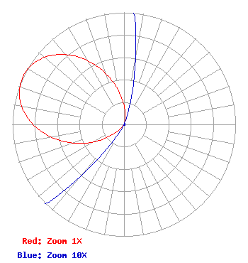 | ||||||||||||||||||
| Azimuth | Ratio | Azimuth | Ratio | Azimuth | Ratio | Azimuth | Ratio | ||||||||||||
| 5 | 0.107 | 15 | 0.026 | 25 | 0.001 | 35 | 0.001 | ||||||||||||
| 45 | 0.001 | 55 | 0.001 | 65 | 0.001 | 75 | 0.001 | ||||||||||||
| 85 | 0.001 | 95 | 0.001 | 105 | 0.001 | 115 | 0.001 | ||||||||||||
| 125 | 0.001 | 135 | 0.001 | 145 | 0.001 | 155 | 0.001 | ||||||||||||
| 165 | 0.001 | 175 | 0.001 | 185 | 0.001 | 195 | 0.001 | ||||||||||||
| 205 | 0.001 | 215 | 0.026 | 225 | 0.107 | 235 | 0.237 | ||||||||||||
| 245 | 0.399 | 255 | 0.574 | 265 | 0.741 | 275 | 0.879 | ||||||||||||
| 285 | 0.969 | 295 | 1.000 | 305 | 0.969 | 315 | 0.879 | ||||||||||||
| 325 | 0.741 | 335 | 0.574 | 345 | 0.399 | 355 | 0.237 | ||||||||||||
Structure Registration Number 1064671 Structure Type: GTOWER Registered To: American Towers, LLC Structure Address: 26567 Ernest Patterson Rd (#300182) Robertsdale, AL County Name: Baldwin County ASR Issued: 02/07/2020 Date Built: 04/06/2001 Site Elevation: 32.3 m (106 ft.) Structure Height: 550 m (1804 ft.) Height Overall: 577.3 m (1894 ft.) Overall Height AMSL: 609.6 m (2000 ft.) FAA Determination: 09/19/2008 FAA Study #: 2008-ASO-4938-OE FAA Circular #: 70/7460-1K Paint & Light FAA Chapters: 4, 9, 12 PRIOR STUDY 2008-ASO-2310-OE 30-36-41.0 N 87-36-26.4 W (NAD 83) 30-36-40.3 N 87-36-26.5 W (Converted to NAD 27)  American Tower Corporation 300182 - Mobile AL 2 |
Po Box 1010 Marion, IL 62959 Phone: 618-997-4700 Not-for-Profit | Title: Vice-president, Legal Date: 06/08/2023 Application Certifier RADIANT LIFE MINISTRIES, INC. Radiant Life Ministries, Inc. Po Box 1010 Marion, IL 62959 Applicant Kevin T Fisher Smith And Fisher, Llc 4791 Wintergreen Court Woodbridge, VA 22192 Engineering Consultant Joseph C Chautin, III Hardy, Carey, Chautin & Balkin, Llp 1080 W. Causeway Approach Mandeville, LA 70471 Attorney at Law | |||||||||||||||||