
FCCInfo.com
A Service of Cavell, Mertz & Associates, Inc.
(855) FCC-INFO
|
|
K20PC-D from 02/25/2010 |
|
|
||||||||||||||||
|
|
Status: Construction Permit Application Accepted: 06/27/2023 K20PC-D CP Expires: 06/29/2026 File Number: -0000216862 FCC Website Links: LMS Facility Details This Application Other K20PC-D Applications Including Superseded Applications Mailing Address Correspondence for K20PC-D Correspondence related to application -0000216862 Service Contour - Open Street Map or USGS Map (51 dBu) Service Contour - KML / Google Earth (51 dBu) Rabbit Ears Info Search for K20PC-D Site Location: 31-03-58.6 N 95-31-35.4 W (NAD 83) Site Location: 31-03-57.9 N 95-31-34.6 W (Converted to NAD 27) ERP: 15 kW Polarization: Horizontally polarized Electrical Beam Tilt: 0.50 degrees R/C AGL: 122 m (400 ft.) R/C AMSL: 208 m (682 ft.) Emission Mask: Full Service Site Elevation: 86 m. (282 ft.) Height Overall*: 182.6 m (599 ft.) (* As Filed In This Application, may differ from ASR Data, Below.) Directional Antenna - Antenna Make/Model: IRTE 1230 EH Antenna ID: Polarization: Horizontally polarized | ||||||||||||||||||
| Antenna Data for Antenna Id: K20PC-D LD File: -0000216862 IRTE - 1230 EH Service: LD Standard Pattern: N Pattern and Field Values Include a 189.0° Clockwise Rotation | 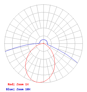 | ||||||||||||||||||
| Azimuth | Ratio | Azimuth | Ratio | Azimuth | Ratio | Azimuth | Ratio | ||||||||||||
| 9 | 0.010 | 19 | 0.010 | 29 | 0.010 | 39 | 0.010 | ||||||||||||
| 49 | 0.010 | 59 | 0.010 | 69 | 0.010 | 79 | 0.010 | ||||||||||||
| 89 | 0.010 | 99 | 0.010 | 109 | 0.021 | 119 | 0.094 | ||||||||||||
| 129 | 0.218 | 139 | 0.378 | 149 | 0.556 | 159 | 0.729 | ||||||||||||
| 169 | 0.872 | 179 | 0.967 | 189 | 1.000 | 199 | 0.967 | ||||||||||||
| 209 | 0.872 | 219 | 0.729 | 229 | 0.556 | 239 | 0.378 | ||||||||||||
| 249 | 0.218 | 259 | 0.094 | 269 | 0.021 | 279 | 0.010 | ||||||||||||
| 289 | 0.010 | 299 | 0.010 | 309 | 0.010 | 319 | 0.010 | ||||||||||||
| 329 | 0.010 | 339 | 0.010 | 349 | 0.010 | 359 | 0.010 | ||||||||||||
Structure Registration Number 1284851 Structure Type: GTOWER Registered To: Aleluya Broadcasting Network Structure Address: 6.5 Miles Sw Of Lovelady, Tx & 1,260' From The Int. Of County Rds. 3555 & 3625. Lovelady, TX County Name: Houston County ASR Issued: 08/16/2012 Date Built: 11/20/2012 Site Elevation: 86 m (282 ft.) Structure Height: 181.7 m (596 ft.) Height Overall: 182.6 m (599 ft.) Overall Height AMSL: 268.6 m (881 ft.) FAA Determination: 06/21/2012 FAA Study #: 2012-ASW-3991-OE FAA Circular #: 70/7460-1K Paint & Light FAA Chapters: 3, 4, 5, 12 31-03-58.6 N 95-31-35.4 W (NAD 83) 31-03-57.9 N 95-31-34.6 W (Converted to NAD 27) |
1024 Wafer St. Pasadena, TX 77506 Phone: 713-589-1336 Limited Liability Company | Title: Manager Date: 06/27/2023 Application Certifier DAIJ MEDIA, LLC Daij Media, Llc 1024 Wafer St. Pasadena, TX 77506 Applicant Jim McPhetridge Jim Mcphetridge 104 Woodmont Montgomery, TX 77356 Broadcast Engineer | |||||||||||||||||