
FCCInfo.com
A Service of Cavell, Mertz & Associates, Inc.
(855) FCC-INFO
|
|
WXVK-LD from 04/19/1995 WXVK-LD from 02/01/1995 WXVK-LD from 12/11/1992 |
|
|
||||||||||||||||
|
|
Status: Construction Permit Application Accepted: 06/30/2023 WXVK-LD CP Expires: 07/07/2026 File Number: -0000217326 FCC Website Links: LMS Facility Details This Application Other WXVK-LD Applications Including Superseded Applications Mailing Address Correspondence for WXVK-LD Correspondence related to application -0000217326 Service Contour - Open Street Map or USGS Map (51 dBu) Service Contour - KML / Google Earth (51 dBu) Rabbit Ears Info Search for WXVK-LD Site Location: 32-35-55.4 N 85-12-19.7 W (NAD 83) Site Location: 32-35-54.9 N 85-12-19.9 W (Converted to NAD 27) ERP: 15 kW Polarization: Horizontally polarized R/C AGL: 73 m (240 ft.) R/C AMSL: 269.9 m (885 ft.) Emission Mask: Full Service Site Elevation: 196.9 m. (646 ft.) Height Overall*: 106.4 m (349 ft.) (* As Filed In This Application, may differ from ASR Data, Below.) Directional Antenna - Antenna Make/Model: Propagation System Inc PSILP12OI Antenna ID: 1010851 Polarization: Horizontally polarized | ||||||||||||||||||
| Antenna Data for Antenna Id: 1010851 WXVK-LD LD File: -0000217326 Propagation System Inc - PSILP12OI Service: LD Standard Pattern: N Pattern and Field Values Include a 125.0° Clockwise Rotation | 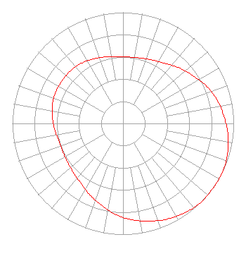 | ||||||||||||||||||
| Azimuth | Ratio | Azimuth | Ratio | Azimuth | Ratio | Azimuth | Ratio | ||||||||||||
| 5 | 0.600 | 15 | 0.610 | 25 | 0.630 | 35 | 0.660 | ||||||||||||
| 45 | 0.710 | 55 | 0.760 | 65 | 0.820 | 75 | 0.870 | ||||||||||||
| 85 | 0.910 | 95 | 0.950 | 105 | 0.980 | 115 | 1.000 | ||||||||||||
| 125 | 1.000 | 135 | 1.000 | 145 | 0.980 | 155 | 0.950 | ||||||||||||
| 165 | 0.910 | 175 | 0.870 | 185 | 0.820 | 195 | 0.760 | ||||||||||||
| 205 | 0.710 | 215 | 0.660 | 225 | 0.630 | 235 | 0.610 | ||||||||||||
| 245 | 0.600 | 255 | 0.600 | 265 | 0.620 | 275 | 0.640 | ||||||||||||
| 285 | 0.660 | 295 | 0.670 | 305 | 0.670 | 315 | 0.670 | ||||||||||||
| 325 | 0.660 | 335 | 0.640 | 345 | 0.620 | 355 | 0.600 | ||||||||||||
Structure Registration Number 1219605 Structure Type: TOWER Registered To: American Towers, LLC Structure Address: 10722 Us Highway 280 East Salem, AL County Name: Lee County ASR Issued: 02/07/2020 Date Built: 09/27/2000 Site Elevation: 196.9 m (646 ft.) Structure Height: 100.6 m (330 ft.) Height Overall: 106.4 m (349 ft.) Overall Height AMSL: 303.3 m (995 ft.) FAA Determination: 08/04/2000 FAA Study #: 00-ASO-3461-OE FAA Circular #: 70/7460-1K Paint & Light FAA Chapters: 4, 8, 12 Removed expiration date from determination. Scenario 1./jjs/case#635066 32-35-55.4 N 85-12-19.7 W (NAD 83) 32-35-54.9 N 85-12-19.9 W (Converted to NAD 27)  American Tower Corporation 300136 - Salem AL 3 |
Po Box 11409 Chattanooga, TN 37401 Phone: 423-468-5100 Limited Liability Company | Title: Coo Date: 06/30/2023 Application Certifier Digital Networks-southeast, Llc Po Box 11409 Chattanooga, TN 37401 Applicant Timothy Z Sawyer T Z Sawyer Technical Consultants 2130 Hutchison Grove Court Suite 100 Falls Church, VA 22043 Technical Consultant Aaron P Shainis Shainis & Peltzman, Chartered 1850 M Street Nw Suite 240 Washington, DC 20036 Legal Counsel | |||||||||||||||||