
FCCInfo.com
A Service of Cavell, Mertz & Associates, Inc.
(855) FCC-INFO
|
|
KFDF-CD from 10/23/2006 |
Post-repack Channel 25 |
|
||||||||||||||||
|
|
Repacking Information: Pre-Repack Channel: 44 Post-Repack Channel: 25 Post-Repack ERP: 10.2 kW Phase: 2 Completion Deadline: 4/12/2019 Find nearby TV Facilities Status: License Application Accepted: 06/29/2023 License Expires: 06/01/2029 File Number: -0000217290 FCC Website Links: LMS Facility Details This Application Other KFDF-CD Applications Including Superseded Applications Mailing Address Correspondence for KFDF-CD Correspondence related to application -0000217290 Service Contour - Open Street Map or USGS Map (51 dBu) Service Contour - KML / Google Earth (51 dBu) Public Inspection Files Rabbit Ears Info Search for KFDF-CD Site Location: 35-26-51.3 N 94-21-54.8 W (NAD 83) Site Location: 35-26-51.0 N 94-21-54.0 W (Converted to NAD 27) ERP: 15 kW Polarization: Horizontally polarized Electrical Beam Tilt: 0.75 degrees R/C AGL: 53.7 m (176 ft.) R/C AMSL: 300.6 m (986 ft.) Emission Mask: Full Service Site Elevation: 246.9 m. (810 ft.) Height Overall*: 95.4 m (313 ft.) (* As Filed In This Application, may differ from ASR Data, Below.) Directional Antenna - Antenna Make/Model: Propagation System Inc PSILPD801-20/22/25 Antenna ID: 1010846 Polarization: Horizontally polarized | ||||||||||||||||||
| Antenna Data for Antenna Id: 1010846 KFDF-CD DC File: -0000217290 Propagation System Inc - PSILPD801-20/22/25 Service: DC Standard Pattern: N Pattern and Field Values Include a 180° Clockwise Rotation | 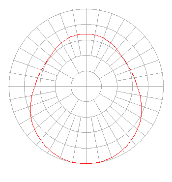 | ||||||||||||||||||
| Azimuth | Ratio | Azimuth | Ratio | Azimuth | Ratio | Azimuth | Ratio | ||||||||||||
| 0 | 0.670 | 10 | 0.670 | 20 | 0.660 | 30 | 0.640 | ||||||||||||
| 40 | 0.620 | 50 | 0.600 | 60 | 0.600 | 70 | 0.610 | ||||||||||||
| 80 | 0.630 | 90 | 0.660 | 100 | 0.710 | 110 | 0.760 | ||||||||||||
| 120 | 0.820 | 130 | 0.870 | 140 | 0.910 | 150 | 0.950 | ||||||||||||
| 160 | 0.980 | 170 | 1.000 | 180 | 1.000 | 190 | 1.000 | ||||||||||||
| 200 | 0.980 | 210 | 0.950 | 220 | 0.910 | 230 | 0.870 | ||||||||||||
| 240 | 0.820 | 250 | 0.760 | 260 | 0.710 | 270 | 0.660 | ||||||||||||
| 280 | 0.630 | 290 | 0.610 | 300 | 0.600 | 310 | 0.600 | ||||||||||||
| 320 | 0.620 | 330 | 0.640 | 340 | 0.660 | 350 | 0.670 | ||||||||||||
Structure Registration Number 1236377 Structure Type: TOWER Registered To: American Towers LLC Structure Address: Pernot Road Van Burent, AR County Name: Crawford County ASR Issued: 01/05/2021 Date Built: 10/31/2003 Site Elevation: 246.9 m (810 ft.) Structure Height: 94.5 m (310 ft.) Height Overall: 95.4 m (313 ft.) Overall Height AMSL: 342.3 m (1123 ft.) FAA Determination: 10/11/2002 FAA Study #: 2002-ASW-4081-OE FAA Circular #: 70/7460-1K Paint & Light FAA Chapters: 4, 8, 12 PRIOR STUDY 2002-ASW-2422-OE 35-26-51.3 N 94-21-54.8 W (NAD 83) 35-26-51.0 N 94-21-54.0 W (Converted to NAD 27) |
Little Rock, AR 72212 Phone: 501-500-0130 Limited Liability Company | Title: Manager Date: 06/29/2023 Application Certifier KTV MEDIA Ktv Media, Llc Little Rock, AR 72212 Applicant Jim McPhetridge Wes Broadcasting 228 Flynn Drive El Paso, TX 79932 Broadcast Engineering Consultant Larry Morton Ellis-wilson, Llc Little Rock, AR 72221 Manager | |||||||||||||||||