
FCCInfo.com
A Service of Cavell, Mertz & Associates, Inc.
(855) FCC-INFO
|
|
|
Virtual Channel 23 |
|
||||||||||||||||
|
|
Status: License Application Accepted: 07/11/2023 License Expires: 12/01/2029 File Number: -0000217813 FCC Website Links: LMS Facility Details This Application Other WIFR-LD Applications Including Superseded Applications Mailing Address Correspondence for WIFR-LD Correspondence related to application -0000217813 Service Contour - Open Street Map or USGS Map (51 dBu) Service Contour - KML / Google Earth (51 dBu) Rabbit Ears Info Search for WIFR-LD Site Location: 42-17-48.3 N 89-10-15.0 W (NAD 83) Site Location: 42-17-48.2 N 89-10-14.6 W (Converted to NAD 27) ERP: 15 kW Polarization: Elliptically polarized Electrical Beam Tilt: 0.75 degrees R/C AGL: 199.6 m (655 ft.) R/C AMSL: 448.9 m (1473 ft.) Emission Mask: Full Service Site Elevation: 249.3 m. (818 ft.) Height Overall*: 214.3 m (703 ft.) (* As Filed In This Application, may differ from ASR Data, Below.) Directional Antenna - Antenna Make/Model: Electronics Research Inc. ALP12L3-ESWR-28 Antenna ID: 1005677 Polarization: Elliptically polarized | ||||||||||||||||||
| Antenna Data for Antenna Id: 1005677 WIFR-LD LD File: -0000217813 Electronics Research Inc. - ALP12L3-ESWR-28 Service: LD Standard Pattern: Y Pattern and Field Values Include a 210° Clockwise Rotation | 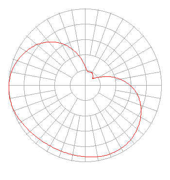 | ||||||||||||||||||
| Azimuth | Ratio | Azimuth | Ratio | Azimuth | Ratio | Azimuth | Ratio | ||||||||||||
| 0 | 0.249 | 10 | 0.183 | 20 | 0.181 | 30 | 0.185 | ||||||||||||
| 40 | 0.160 | 48 | 0.137 | 50 | 0.137 | 60 | 0.201 | ||||||||||||
| 70 | 0.326 | 80 | 0.463 | 90 | 0.588 | 100 | 0.691 | ||||||||||||
| 110 | 0.775 | 120 | 0.840 | 130 | 0.892 | 140 | 0.930 | ||||||||||||
| 150 | 0.950 | 160 | 0.958 | 170 | 0.949 | 180 | 0.934 | ||||||||||||
| 190 | 0.922 | 200 | 0.915 | 210 | 0.914 | 220 | 0.924 | ||||||||||||
| 230 | 0.939 | 240 | 0.962 | 250 | 0.986 | 260 | 0.998 | ||||||||||||
| 262 | 1.000 | 270 | 0.994 | 280 | 0.976 | 290 | 0.939 | ||||||||||||
| 300 | 0.887 | 310 | 0.821 | 320 | 0.736 | 330 | 0.631 | ||||||||||||
| 340 | 0.504 | 350 | 0.369 | ||||||||||||||||
Structure Registration Number 1209945 Structure Type: GTOWER Registered To: Gray Media Group, Inc. Structure Address: 2523 North Meridian Road Rockford, IL County Name: Winnebago County ASR Issued: 08/25/2022 Date Built: 03/01/2000 Site Elevation: 249.3 m (818 ft.) Structure Height: 205.9 m (676 ft.) Height Overall: 214.3 m (703 ft.) Overall Height AMSL: 463.6 m (1521 ft.) FAA Determination: 04/26/2021 FAA Study #: 2021-AGL-7283-OE Paint & Light FAA Chapters: 1, 3, 6, 15, 21 Continue As Is OM&L = PAINT/RED LIGHTS 42-17-48.3 N 89-10-15.0 W (NAD 83) 42-17-48.2 N 89-10-14.6 W (Converted to NAD 27) |
4370 Peachtree Road, Ne Atlanta, GA 30319 Phone: 202-750-1585 Limited Liability Company | Title: Assistant Secretary Date: 07/11/2023 Application Certifier Gray Television Licensee, Llc 4370 Peachtree Road, Ne Atlanta, GA 30319 Applicant Joseph M. Davis, P.E. Chesapeake Rf Consultants, Llc 207 Old Dominion Road Yorktown, VA 23692 Consulting Engineer Joan Stewart Wiley Rein Llp 2050 M Street, Nw Washington, DC 20036 | |||||||||||||||||