
FCCInfo.com
A Service of Cavell, Mertz & Associates, Inc.
(855) FCC-INFO
|
|
K28QF-D from 07/29/2021 K28QF-D from 02/22/2011 |
|
|
||||||||||||||||
|
|
Status: License Application Accepted: 07/13/2023 License Expires: 08/01/2022 File Number: -0000217875 FCC Website Links: LMS Facility Details This Application Other KAQI-LD Applications Including Superseded Applications Mailing Address Correspondence for KAQI-LD Correspondence related to application -0000217875 Service Contour - Open Street Map or USGS Map (51 dBu) Service Contour - KML / Google Earth (51 dBu) Rabbit Ears Info Search for KAQI-LD Site Location: 34-01-58.0 N 96-48-01.0 W (NAD 83) Site Location: 34-01-57.6 N 96-47-60.0 W (Converted to NAD 27) ERP: 15 kW Polarization: Elliptically polarized Electrical Beam Tilt: 1.0 degree R/C AGL: 457.2 m (1500 ft.) R/C AMSL: 728.4 m (2390 ft.) Emission Mask: Full Service Site Elevation: 271.2 m. (890 ft.) Height Overall*: 516.3 m (1694 ft.) (* As Filed In This Application, may differ from ASR Data, Below.) Directional Antenna - Antenna Make/Model: Dielectric TLP-12H/VP Antenna ID: 1008492 Polarization: Elliptically polarized | ||||||||||||||||||
| Antenna Data for Antenna Id: 1008492 KAQI-LD LD File: -0000217875 Dielectric - TLP-12H/VP Service: LD Standard Pattern: N Pattern and Field Values Include a 90° Clockwise Rotation | 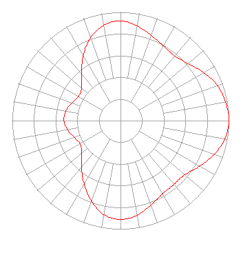 | ||||||||||||||||||
| Azimuth | Ratio | Azimuth | Ratio | Azimuth | Ratio | Azimuth | Ratio | ||||||||||||
| 0 | 0.918 | 10 | 0.885 | 20 | 0.834 | 30 | 0.793 | ||||||||||||
| 40 | 0.777 | 50 | 0.816 | 60 | 0.885 | 70 | 0.949 | ||||||||||||
| 80 | 0.984 | 90 | 1.000 | 100 | 0.977 | 110 | 0.917 | ||||||||||||
| 120 | 0.842 | 130 | 0.776 | 140 | 0.768 | 150 | 0.779 | ||||||||||||
| 160 | 0.828 | 170 | 0.885 | 180 | 0.911 | 190 | 0.880 | ||||||||||||
| 200 | 0.788 | 210 | 0.673 | 220 | 0.560 | 230 | 0.467 | ||||||||||||
| 240 | 0.430 | 250 | 0.452 | 260 | 0.495 | 270 | 0.521 | ||||||||||||
| 280 | 0.511 | 290 | 0.477 | 300 | 0.446 | 310 | 0.468 | ||||||||||||
| 320 | 0.560 | 330 | 0.688 | 340 | 0.810 | 350 | 0.891 | ||||||||||||
Structure Registration Number 1011273 Structure Type: TOWER Registered To: Gray Media Group, Inc. Structure Address: Hwy 99 8.05 Km Ssw Madill, OK County Name: Marshall County ASR Issued: 09/09/2020 Date Built: 02/01/1984 Site Elevation: 271.2 m (890 ft.) Structure Height: 487.6 m (1600 ft.) Height Overall: 516.3 m (1694 ft.) Overall Height AMSL: 787.5 m (2584 ft.) Paint & Light FAA Chapters: A1, B, F, H 34-01-58.0 N 96-48-01.0 W (NAD 83) 34-01-57.6 N 96-47-60.0 W (Converted to NAD 27) |
4370 Peachtree Road, Ne Atlanta, GA 30319 Phone: 202-750-1585 Limited Liability Company | Title: Assistant Secretary Date: 07/13/2023 Application Certifier Gray Television Licensee, Llc 4370 Peachtree Road, Ne Atlanta, GA 30319 Applicant Joan Stewart Wiley Rein Llp 2050 M Street, Nw Washington, DC 20036 | |||||||||||||||||