
FCCInfo.com
A Service of Cavell, Mertz & Associates, Inc.
(855) FCC-INFO
|
|
KLFB-LD from 07/20/2006 KLFB-LD from 05/23/1995 |
|
|
||||||||||||||||
|
|
Status: License Application Accepted: 07/19/2023 License Expires: 12/01/2022 File Number: -0000218134 FCC Website Links: LMS Facility Details This Application Other KLFB-LD Applications Including Superseded Applications Mailing Address Correspondence for KLFB-LD Correspondence related to application -0000218134 Service Contour - Open Street Map or USGS Map (51 dBu) Service Contour - KML / Google Earth (51 dBu) Rabbit Ears Info Search for KLFB-LD Site Location: 36-32-05.0 N 121-37-18.0 W (NAD 83) Site Location: 36-32-05.1 N 121-37-14.2 W (Converted to NAD 27) ERP: 15 kW Polarization: Elliptically polarized R/C AGL: 40 m (131 ft.) R/C AMSL: 1073.3 m (3521 ft.) Emission Mask: Stringent Site Elevation: 1033.3 m. (3390 ft.) Height Overall*: 68.9 m (226 ft.) (* As Filed In This Application, may differ from ASR Data, Below.) Directional Antenna - Antenna Make/Model: IRTE 2 X 1 PANEL Antenna ID: 1010586 Polarization: Elliptically polarized | ||||||||||||||||||
| Antenna Data for Antenna Id: 1010586 KLFB-LD LD File: -0000218134 IRTE - 2 X 1 PANEL Service: LD Standard Pattern: Y | 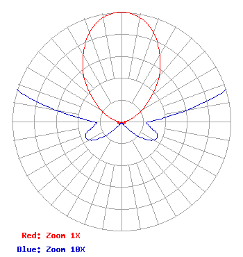 | ||||||||||||||||||
| Azimuth | Ratio | Azimuth | Ratio | Azimuth | Ratio | Azimuth | Ratio | ||||||||||||
| 0 | 1.000 | 10 | 0.966 | 20 | 0.861 | 30 | 0.700 | ||||||||||||
| 40 | 0.537 | 50 | 0.355 | 60 | 0.226 | 70 | 0.126 | ||||||||||||
| 80 | 0.061 | 90 | 0.026 | 100 | 0.026 | 110 | 0.035 | ||||||||||||
| 120 | 0.034 | 130 | 0.022 | 140 | 0.008 | 150 | 0.003 | ||||||||||||
| 160 | 0.002 | 170 | 0.001 | 180 | 0.001 | 190 | 0.001 | ||||||||||||
| 200 | 0.002 | 210 | 0.003 | 220 | 0.008 | 230 | 0.022 | ||||||||||||
| 240 | 0.034 | 250 | 0.035 | 260 | 0.026 | 270 | 0.026 | ||||||||||||
| 280 | 0.062 | 290 | 0.126 | 300 | 0.226 | 310 | 0.355 | ||||||||||||
| 320 | 0.537 | 330 | 0.700 | 340 | 0.861 | 350 | 0.966 | ||||||||||||
Structure Registration Number 1015714 Structure Type: TOWER Registered To: NPG OF MONTEREY-SALINAS CA, LLC Structure Address: Mount Toro Monterey, CA County Name: Monterey County ASR Issued: 04/25/2014 Date Built: 10/01/1968 Site Elevation: 1033.3 m (3390 ft.) Structure Height: 68.9 m (226 ft.) Height Overall: 68.9 m (226 ft.) Overall Height AMSL: 1102.2 m (3616 ft.) FAA Determination: 03/03/1976 FAA Study #: SFO-OE-68-111 Paint & Light FAA Chapters: 1, 3, 11, 21 36-32-05.0 N 121-37-18.0 W (NAD 83) 36-32-05.1 N 121-37-14.2 W (Converted to NAD 27) |
3391 Charley Good Road West Frankfort, IL 62896 Phone: 618-627-4651 Not-for-Profit | Title: President Date: 07/19/2023 Application Certifier 3ABN Three Angels Broadcasting Network, Inc. 3391 Charley Good Road West Frankfort, IL 62896 Applicant Greg Best Greg Best Consulting, Inc. 16100 Outlook Ave Stilwell, KS 66085 Consulting Engineer Daniel Peek Three Angels Broadcasting Network Po Box 220 3391 Charley Good Raod West Frankfort, IL 62896 Moses Primo Three Angels Broadcasting Network 3391 Charley Good Road West Frankfort, IL 62896 Legal Representative | |||||||||||||||||