
FCCInfo.com
A Service of Cavell, Mertz & Associates, Inc.
(855) FCC-INFO
|
|
W31EV-D from 02/22/2011 |
|
|
||||||||||||||||
|
|
Status: Construction Permit Application Accepted: 08/10/2023 W31EV-D CP Expires: 08/15/2026 File Number: -0000193285 FCC Website Links: LMS Facility Details This Application Other W31EV-D Applications Including Superseded Applications Mailing Address Correspondence for W31EV-D Correspondence related to application -0000193285 Service Contour - Open Street Map or USGS Map (51 dBu) Service Contour - KML / Google Earth (51 dBu) Rabbit Ears Info Search for W31EV-D Site Location: 44-35-46.8 N 89-36-20.1 W (NAD 83) Site Location: 44-35-46.9 N 89-36-19.7 W (Converted to NAD 27) ERP: 15 kW Polarization: Horizontally polarized Electrical Beam Tilt: 0.5 degrees R/C AGL: 54.9 m (180 ft.) R/C AMSL: 403 m (1322 ft.) Emission Mask: Full Service Site Elevation: 348.1 m. (1142 ft.) Height Overall*: 78.9 m (259 ft.) (* As Filed In This Application, may differ from ASR Data, Below.) Directional Antenna - Antenna Make/Model: Dielectric TLP-8M Antenna ID: 1010977 Polarization: Horizontally polarized | ||||||||||||||||||
| Antenna Data for Antenna Id: 1010977 W31EV-D LD File: -0000193285 Dielectric - TLP-8M Service: LD Standard Pattern: N Pattern and Field Values Include a 240° Clockwise Rotation | 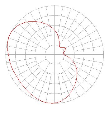 | ||||||||||||||||||
| Azimuth | Ratio | Azimuth | Ratio | Azimuth | Ratio | Azimuth | Ratio | ||||||||||||
| 0 | 0.497 | 10 | 0.392 | 20 | 0.280 | 30 | 0.197 | ||||||||||||
| 40 | 0.184 | 50 | 0.226 | 60 | 0.257 | 70 | 0.227 | ||||||||||||
| 80 | 0.183 | 90 | 0.194 | 100 | 0.278 | 110 | 0.393 | ||||||||||||
| 120 | 0.502 | 130 | 0.599 | 140 | 0.688 | 150 | 0.778 | ||||||||||||
| 160 | 0.873 | 170 | 0.951 | 180 | 0.993 | 187 | 1.000 | ||||||||||||
| 190 | 0.998 | 200 | 0.976 | 210 | 0.944 | 220 | 0.918 | ||||||||||||
| 230 | 0.901 | 240 | 0.895 | 250 | 0.908 | 260 | 0.921 | ||||||||||||
| 270 | 0.942 | 280 | 0.974 | 290 | 0.995 | 292 | 0.996 | ||||||||||||
| 300 | 0.985 | 310 | 0.940 | 320 | 0.865 | 330 | 0.775 | ||||||||||||
| 340 | 0.684 | 350 | 0.593 | ||||||||||||||||
Structure Registration Number 1230549 Structure Type: LTOWER Registered To: American Towers LLC Structure Address: 2380 North Second Street (375205) Stevens Point, WI County Name: Portage County ASR Issued: 12/13/2023 Date Built: 05/27/2004 Site Elevation: 348.1 m (1142 ft.) Structure Height: 76.5 m (251 ft.) Height Overall: 78.9 m (259 ft.) Overall Height AMSL: 427 m (1401 ft.) FAA Determination: 01/20/2023 FAA Study #: 2022-AGL-7621-OE FAA Circular #: 70/7460-1K Paint & Light FAA Chapters: 4, 8, 12 OM&L to remain the same as prior study = A MED-DUAL SYSTEM 44-35-46.8 N 89-36-20.0 W (NAD 83) 44-35-46.9 N 89-36-19.6 W (Converted to NAD 27) |
4370 Peachtree Rd., Ne Atlanta, GA 30319 Phone: 404-504-9828 Limited Liability Company | Title: Assistant Secretary Date: 08/10/2023 Application Certifier Gray Television Licensee, Llc 4370 Peachtree Rd., Ne Atlanta, GA 30319 Applicant Joan Stewart Wiley Rein Llp 2050 M Street, Nw Washington, DC 20036 Joseph M. Davis, P.E. Chesapeake Rf Consultants, Llc 207 Old Dominion Road Yorktown, VA 23692 Consulting Engineer | |||||||||||||||||