
FCCInfo.com
A Service of Cavell, Mertz & Associates, Inc.
(855) FCC-INFO
|
|
WLXI from 12/30/1981 |
RF spectrum relinquished in the spectrum auction Virtual Channel 61 |
|
||||||||||||||||
|
|
WLXI is a channel sharing guest of WUNC-TV, Chapel Hill, North Carolina WUNL-TV, Winston-salem, North Carolina Repacking Information: Channel 43 was relinquished in the spectrum auction Status: License Application Accepted: 09/28/2023 License Expires: 12/01/2028 File Number: -0000221561 FCC Website Links: LMS Facility Details This Application Other WLXI Applications Including Superseded Applications Mailing Address Correspondence for WLXI Correspondence related to application -0000221561 Service Contour - Open Street Map or USGS Map (41 dBu) Service Contour - KML / Google Earth (41 dBu) Public Inspection Files History Cards for WLXI Rabbit Ears Info Search for WLXI Site Location: 36-22-31.7 N 80-22-17.5 W (NAD 83) Site Location: 36-22-31.2 N 80-22-18.3 W (Converted to NAD 27) ERP: 1000 kW Polarization: Elliptically polarized HAAT: 500.2 m (1641 ft.) Electrical Beam Tilt: 1.0 degree R/C AGL: 100.2 m (329 ft.) R/C AMSL: 819.2 m (2688 ft.) Site Elevation: 719 m. (2359 ft.) Height Overall*: 111.3 m (365 ft.) (* As Filed In This Application, may differ from ASR Data, Below.) Directional Antenna - Antenna Make/Model: R.F. Systems SAA28-ATW_WC-E400-ET5R-33 Antenna ID: 1007297 Polarization: Elliptically polarized | ||||||||||||||||||
| Antenna Data for Antenna Id: 1007297 WLXI DT File: -0000221561 R.F. Systems - SAA28-ATW_WC-E400-ET5R-33 Service: DT Standard Pattern: Y | 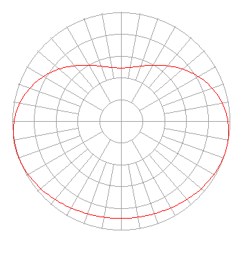 | ||||||||||||||||||
| Azimuth | Ratio | Azimuth | Ratio | Azimuth | Ratio | Azimuth | Ratio | ||||||||||||
| 0 | 0.488 | 10 | 0.500 | 20 | 0.536 | 30 | 0.592 | ||||||||||||
| 40 | 0.663 | 50 | 0.741 | 60 | 0.819 | 70 | 0.889 | ||||||||||||
| 80 | 0.944 | 90 | 0.981 | 100 | 0.998 | 105 | 1.000 | ||||||||||||
| 110 | 0.998 | 120 | 0.984 | 130 | 0.963 | 140 | 0.940 | ||||||||||||
| 150 | 0.919 | 160 | 0.904 | 170 | 0.896 | 180 | 0.893 | ||||||||||||
| 190 | 0.896 | 200 | 0.904 | 210 | 0.919 | 220 | 0.940 | ||||||||||||
| 230 | 0.963 | 240 | 0.984 | 250 | 0.998 | 255 | 1.000 | ||||||||||||
| 260 | 0.998 | 270 | 0.981 | 280 | 0.944 | 290 | 0.889 | ||||||||||||
| 300 | 0.819 | 310 | 0.741 | 320 | 0.663 | 330 | 0.592 | ||||||||||||
| 340 | 0.536 | 350 | 0.500 | ||||||||||||||||
Structure Registration Number 1014577 Structure Type: GTOWER Registered To: UNIVERSITY OF NORTH CAROLINA Structure Address: 2463 Sauratown Mountain Road Westfield, NC County Name: Stokes County ASR Issued: 11/21/2023 Date Built: 04/05/2024 Site Elevation: 719 m (2359 ft.) Structure Height: 92 m (302 ft.) Height Overall: 111.3 m (365 ft.) Overall Height AMSL: 830.3 m (2724 ft.) FAA Determination: 10/04/2023 FAA Study #: 2022-ASO-42344-OE FAA Circular #: 70/7460-1M Paint & Light FAA Chapters: 4, 8, 15 PRIOR STUDY 2017-ASO-21956-OE 36-22-32.6 N 80-22-17.0 W (NAD 83) 36-22-32.1 N 80-22-17.8 W (Converted to NAD 27) |
Marion, IL 62959 Phone: 618-997-4700 Not-for-Profit | Title: Vice-president, Legal Date: 09/28/2023 Application Certifier Radiant Life Ministries, Inc. Marion, IL 62959 Applicant Joseph C. Chautin III Hardy, Carey, Chautin & Balkin, Llp 1080 West Causeway Approach Mandeville, LA 70471 Louis R duTreil, Jr Dutreil Lundin & Rackley Inc 5212 Station Way Sarasota, FL 34233 Technical Consultant | |||||||||||||||||
| |||||||||||||||||||