
FCCInfo.com
A Service of Cavell, Mertz & Associates, Inc.
(855) FCC-INFO
|
|
KTAV-LD from 09/28/2001 KTAV-LD from 03/23/2001 KTAV-LD from 04/15/1998 KTAV-LD from 09/23/1992 |
Virtual Channel 35 |
|
||||||||||||||||
|
|
Status: License Application Accepted: 08/23/2023 License Expires: 12/01/2030 File Number: -0000219786 FCC Website Links: LMS Facility Details This Application Other KTAV-LD Applications Including Superseded Applications Mailing Address Correspondence for KTAV-LD Correspondence related to application -0000219786 Service Contour - Open Street Map or USGS Map (51 dBu) Service Contour - KML / Google Earth (51 dBu) Rabbit Ears Info Search for KTAV-LD Site Location: 34-13-55.0 N 118-04-21.0 W (NAD 83) Site Location: 34-13-55.0 N 118-04-17.8 W (Converted to NAD 27) ERP: 0.5 kW Polarization: Circularly polarized Electrical Beam Tilt: 1.75 degrees R/C AGL: 30 m (98 ft.) R/C AMSL: 1754.7 m (5757 ft.) Emission Mask: Full Service Site Elevation: 1724.7 m. (5658 ft.) Height Overall*: 296.4 m (972 ft.) (* As Filed In This Application, may differ from ASR Data, Below.) Directional Antenna - Antenna Make/Model: IRTE 1230 V/H array Antenna ID: 1011025 Polarization: Circularly polarized | ||||||||||||||||||
| Antenna Data for Antenna Id: 1011025 KTAV-LD LD File: -0000219786 IRTE - 1230 V/H array Service: LD Standard Pattern: N Pattern and Field Values Include a 157° Clockwise Rotation | 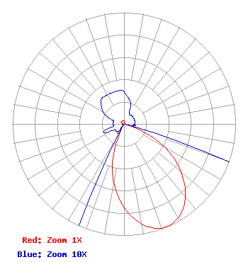 | ||||||||||||||||||
| Azimuth | Ratio | Azimuth | Ratio | Azimuth | Ratio | Azimuth | Ratio | ||||||||||||
| 7 | 0.025 | 17 | 0.020 | 27 | 0.010 | 37 | 0.010 | ||||||||||||
| 47 | 0.010 | 57 | 0.010 | 67 | 0.010 | 77 | 0.010 | ||||||||||||
| 87 | 0.010 | 97 | 0.010 | 107 | 0.030 | 117 | 0.352 | ||||||||||||
| 127 | 0.598 | 137 | 0.805 | 147 | 0.945 | 157 | 1.000 | ||||||||||||
| 167 | 0.945 | 177 | 0.805 | 187 | 0.598 | 197 | 0.352 | ||||||||||||
| 207 | 0.030 | 217 | 0.010 | 227 | 0.010 | 237 | 0.010 | ||||||||||||
| 247 | 0.020 | 257 | 0.010 | 267 | 0.010 | 277 | 0.010 | ||||||||||||
| 287 | 0.010 | 297 | 0.020 | 307 | 0.025 | 317 | 0.030 | ||||||||||||
| 327 | 0.030 | 337 | 0.030 | 347 | 0.030 | 357 | 0.030 | ||||||||||||
Structure Registration Number 1012836 Structure Type: GTOWER Registered To: American Towers LLC Structure Address: 123 Cbs Lane Mount Wilson, CA County Name: Los Angeles County ASR Issued: 05/17/2017 Date Built: 01/01/1986 Site Elevation: 1724.7 m (5658 ft.) Structure Height: 274.2 m (900 ft.) Height Overall: 296.4 m (972 ft.) Overall Height AMSL: 2021.1 m (6631 ft.) FAA Determination: 06/05/1997 FAA Study #: 97-AWP-1265-OE Paint & Light FAA Chapters: 1, 3, 6, 15, 21 RED LIGHTS/PAINT - SPEC. COND: PARAGRAPH 6 MODIFIED TO REQUIRE LIGHTS AT THE TWO-THIRDS LEVEL ONLY. PARAGRAPHS 15 MODIFIED TO REQUIRE LIGHTS AT THE FIVE-SIXTHS LEVEL ONLY. SHIELDING MUST BE PLACED ON LIGHT UNDERSIDE TO AVOID INTERFERENCE TO OBSERVATORY 34-13-55.0 N 118-04-21.0 W (NAD 83) 34-13-55.0 N 118-04-17.8 W (Converted to NAD 27) |
3189 Airway Ave. Suite E Costa Mesa, CA 92626 Phone: 213-627-8711 Not-for-Profit | Title: President Date: 08/23/2023 Application Certifier ALMA VISION HISPANIC NETWORK, INC. Alma Vision Hispanic Network, Inc. 3189 Airway Ave. Suite E Costa Mesa, CA 92626 Applicant Cary S. Tepper Tepper Law Firm, Llc 4900 Auburn Avenue Suite 100 Bethesda, MD 20814-2632 Communications Counsel | |||||||||||||||||