
FCCInfo.com
A Service of Cavell, Mertz & Associates, Inc.
(855) FCC-INFO
|
|
|
Virtual Channel 12 |
|
||||||||||||||||
|
|
Status: License Application Accepted: 10/16/2023 License Expires: 12/01/2030 File Number: -0000223119 FCC Website Links: LMS Facility Details This Application Other KPJC-LD Applications Including Superseded Applications Mailing Address Correspondence for KPJC-LD Correspondence related to application -0000223119 Service Contour - Open Street Map or USGS Map (48 dBu) Service Contour - KML / Google Earth (48 dBu) Rabbit Ears Info Search for KPJC-LD Site Location: 37-41-12.3 N 122-26-07.3 W (NAD 83) Site Location: 37-41-12.5 N 122-26-03.4 W (Converted to NAD 27) ERP: 0.075 kW Polarization: Horizontally polarized R/C AGL: 21.3 m (70 ft.) R/C AMSL: 411.4 m (1350 ft.) Emission Mask: Full Service Site Elevation: 390.1 m. (1280 ft.) Height Overall*: 78.3 m (257 ft.) (* As Filed In This Application, may differ from ASR Data, Below.) Directional Antenna - Antenna Make/Model: Scala 2x CL-713 Array Antenna ID: 1011182 Polarization: Horizontally polarized | ||||||||||||||||||
| Antenna Data for Antenna Id: 1011182 KPJC-LD LD File: -0000223119 Scala - 2x CL-713 Array Service: LD Standard Pattern: N | 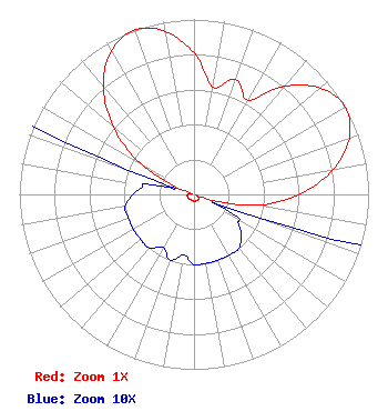 | ||||||||||||||||||
| Azimuth | Ratio | Azimuth | Ratio | Azimuth | Ratio | Azimuth | Ratio | ||||||||||||
| 0 | 0.807 | 10 | 0.622 | 20 | 0.698 | 30 | 0.622 | ||||||||||||
| 40 | 0.807 | 50 | 0.946 | 60 | 1.000 | 70 | 0.946 | ||||||||||||
| 80 | 0.807 | 90 | 0.602 | 100 | 0.359 | 110 | 0.040 | ||||||||||||
| 120 | 0.030 | 130 | 0.035 | 140 | 0.040 | 150 | 0.040 | ||||||||||||
| 160 | 0.040 | 170 | 0.040 | 180 | 0.040 | 190 | 0.035 | ||||||||||||
| 200 | 0.040 | 210 | 0.035 | 220 | 0.040 | 230 | 0.040 | ||||||||||||
| 240 | 0.040 | 250 | 0.040 | 260 | 0.040 | 270 | 0.035 | ||||||||||||
| 280 | 0.030 | 290 | 0.040 | 300 | 0.359 | 310 | 0.602 | ||||||||||||
| 320 | 0.807 | 330 | 0.946 | 340 | 1.000 | 350 | 0.946 | ||||||||||||
Structure Registration Number 1010566 Structure Type: LTOWER Registered To: American Towers LLC Structure Address: 700 Radio Rd (san Bruno Mtn T9 #8250) Daly City, CA County Name: San Mateo County ASR Issued: 02/04/2015 Date Built: 01/01/1956 Site Elevation: 390.1 m (1280 ft.) Structure Height: 61.3 m (201 ft.) Height Overall: 78.3 m (257 ft.) Overall Height AMSL: 468.4 m (1537 ft.) FAA Determination: 11/06/2014 FAA Study #: 2014-AWP-8134-OE FAA Circular #: 70/7460-1K Paint & Light FAA Chapters: 3, 4, 5, 12 PRIOR STUDY 2012-AWP-861-OE 37-41-12.3 N 122-26-07.3 W (NAD 83) 37-41-12.5 N 122-26-03.4 W (Converted to NAD 27) |
Pmb #704 Beverly Hills, CA 90212 Phone: 310-403-5039 Individual | Title: Sole Proprietor/licensee Date: 10/16/2023 Application Certifier JEFF CHANG 269 South Beverly Dr. Pmb #704 Beverly Hills, CA 90212 Applicant Joseph M. Davis, P.E. Chesapeake Rf Consultants, Llc 207 Old Dominion Road Yorktown, VA 23692 Consulting Engineer Kathleen Victory Fletcher Heald & Hildreth, Plc 1300 N. 17th Street Suite 1100 Washington, DC 22209 | |||||||||||||||||