
FCCInfo.com
A Service of Cavell, Mertz & Associates, Inc.
(855) FCC-INFO
|
|
WVUX-LD from 09/18/2007 WVUX-LD from 05/27/2004 |
|
|
||||||||||||||||
|
|
Status: Application Application Accepted: 10/16/2023 License Expires: 00/00/0000 File Number: -0000223140 FCC Website Links: LMS Facility Details This Application Other WVUX-LD Applications Including Superseded Applications Mailing Address Correspondence for WVUX-LD Correspondence related to application -0000223140 Service Contour - Open Street Map or USGS Map (48 dBu) Service Contour - KML / Google Earth (48 dBu) Rabbit Ears Info Search for WVUX-LD Site Location: 39-17-11.8 N 80-21-55.8 W (NAD 83) Site Location: 39-17-11.5 N 80-21-56.5 W (Converted to NAD 27) ERP: 3 kW Polarization: Horizontally polarized Electrical Beam Tilt: 0.50 degrees R/C AGL: 103 m (338 ft.) R/C AMSL: 532.5 m (1747 ft.) Emission Mask: Full Service Site Elevation: 429.5 m. (1409 ft.) Height Overall*: 106.1 m (348 ft.) (* As Filed In This Application, may differ from ASR Data, Below.) Directional Antenna - Antenna Make/Model: Propagation System Inc PSIVLP4OI-10-EP Antenna ID: 1011183 Polarization: Horizontally polarized | ||||||||||||||||||
| Antenna Data for Antenna Id: 1011183 WVUX-LD LD File: -0000223140 Propagation System Inc - PSIVLP4OI-10-EP Service: LD Standard Pattern: N Pattern and Field Values Include a 45° Clockwise Rotation | 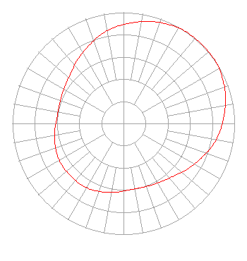 | ||||||||||||||||||
| Azimuth | Ratio | Azimuth | Ratio | Azimuth | Ratio | Azimuth | Ratio | ||||||||||||
| 5 | 0.910 | 15 | 0.950 | 25 | 0.980 | 35 | 1.000 | ||||||||||||
| 45 | 1.000 | 55 | 1.000 | 65 | 0.980 | 75 | 0.950 | ||||||||||||
| 85 | 0.910 | 95 | 0.870 | 105 | 0.820 | 115 | 0.760 | ||||||||||||
| 125 | 0.710 | 135 | 0.660 | 145 | 0.630 | 155 | 0.610 | ||||||||||||
| 165 | 0.600 | 175 | 0.600 | 185 | 0.620 | 195 | 0.640 | ||||||||||||
| 205 | 0.660 | 215 | 0.670 | 225 | 0.670 | 235 | 0.670 | ||||||||||||
| 245 | 0.660 | 255 | 0.640 | 265 | 0.620 | 275 | 0.600 | ||||||||||||
| 285 | 0.600 | 295 | 0.610 | 305 | 0.630 | 315 | 0.660 | ||||||||||||
| 325 | 0.710 | 335 | 0.760 | 345 | 0.820 | 355 | 0.870 | ||||||||||||
Structure Registration Number 1322957 Structure Type: LTOWER Registered To: WVUX LLC Structure Address: Off Stealey Avenue (wvux Tower) Clarksburg, WV County Name: Harrison County ASR Issued: 08/24/2022 Date Built: 07/18/2023 Site Elevation: 429.5 m (1409 ft.) Structure Height: 103.6 m (340 ft.) Height Overall: 106.1 m (348 ft.) Overall Height AMSL: 535.6 m (1757 ft.) FAA Determination: 08/23/2022 FAA Study #: 2022-AEA-9063-OE FAA Circular #: 70/7460-1M Paint & Light FAA Chapters: 4, 8, 15 PRIOR STUDY 2021-AEA-4890-OE 39-17-11.8 N 80-21-55.8 W (NAD 83) 39-17-11.5 N 80-21-56.5 W (Converted to NAD 27) |
St Albans, WV 25177 Phone: 304-539-7975 Individual | Title: Manager Date: 10/16/2023 Application Certifier WVUX 4810 Browns Creek Road St Albans, WV 25177 Applicant Michael Karr Michael Karr 4810 Browns Creek Road St Albans, WV 25177 Owner Jim McPhetridge Jm Mcphetridge 228 Flynn Drive El Paso, TX 79932 Broadcast Engineer Jennifer Scragg Karr Jennifer Scragg Karr Attorney At Law Scott Depot, WV 25560 Attorney | |||||||||||||||||