
FCCInfo.com
A Service of Cavell, Mertz & Associates, Inc.
(855) FCC-INFO
|
|
W15ES-D from 02/22/2011 |
|
|
||||||||||||||||
|
|
Status: License Application Accepted: 10/31/2023 License Expires: 12/01/2028 File Number: -0000224317 FCC Website Links: LMS Facility Details This Application Other W15ES-D Applications Including Superseded Applications Mailing Address Correspondence for W15ES-D Correspondence related to application -0000224317 Service Contour - Open Street Map or USGS Map (51 dBu) Service Contour - KML / Google Earth (51 dBu) Rabbit Ears Info Search for W15ES-D Site Location: 33-26-48.0 N 79-17-58.5 W (NAD 83) Site Location: 33-26-47.4 N 79-17-59.3 W (Converted to NAD 27) ERP: 15 kW Polarization: Elliptically polarized Electrical Beam Tilt: 0.5 degrees R/C AGL: 113.4 m (372 ft.) R/C AMSL: 121.6 m (399 ft.) Emission Mask: Full Service Site Elevation: 8.2 m. (27 ft.) Height Overall*: 152.4 m (500 ft.) (* As Filed In This Application, may differ from ASR Data, Below.) Directional Antenna - Antenna Make/Model: Dielectric TLP-8B/VP Antenna ID: 1011217 Polarization: Elliptically polarized | ||||||||||||||||||
| Antenna Data for Antenna Id: 1011217 W15ES-D LD File: -0000224317 Dielectric - TLP-8B/VP Service: LD Standard Pattern: N Pattern and Field Values Include a 180° Clockwise Rotation | 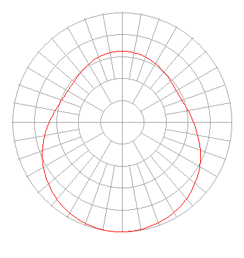 | ||||||||||||||||||
| Azimuth | Ratio | Azimuth | Ratio | Azimuth | Ratio | Azimuth | Ratio | ||||||||||||
| 0 | 0.645 | 10 | 0.641 | 20 | 0.631 | 30 | 0.613 | ||||||||||||
| 40 | 0.592 | 50 | 0.579 | 60 | 0.570 | 70 | 0.579 | ||||||||||||
| 80 | 0.610 | 90 | 0.650 | 100 | 0.699 | 110 | 0.759 | ||||||||||||
| 120 | 0.817 | 130 | 0.869 | 140 | 0.914 | 150 | 0.951 | ||||||||||||
| 160 | 0.975 | 170 | 0.993 | 180 | 1.000 | 190 | 0.996 | ||||||||||||
| 200 | 0.981 | 210 | 0.955 | 220 | 0.920 | 230 | 0.876 | ||||||||||||
| 240 | 0.826 | 250 | 0.771 | 260 | 0.714 | 270 | 0.661 | ||||||||||||
| 280 | 0.615 | 290 | 0.583 | 300 | 0.569 | 310 | 0.571 | ||||||||||||
| 320 | 0.586 | 330 | 0.607 | 340 | 0.627 | 350 | 0.640 | ||||||||||||
Structure Registration Number 1038068 Structure Type: GTOWER Registered To: Alltel Corporation Structure Address: 2390 Browns Ferry Road (476444) Georgetown, SC County Name: Georgetown County ASR Issued: 02/05/2019 Date Built: 08/04/1997 Site Elevation: 8.2 m (27 ft.) Structure Height: 146.3 m (480 ft.) Height Overall: 152.4 m (500 ft.) Overall Height AMSL: 160.6 m (527 ft.) FAA Determination: 06/20/2018 FAA Study #: 2018-ASO-11060-OE Paint & Light FAA Chapters: A2, H, 3, 4, 13, 21, 23 Continue As Is OM&L = A MED-DUAL SYSTEM 33-26-48.0 N 79-17-58.5 W (NAD 83) 33-26-47.4 N 79-17-59.3 W (Converted to NAD 27) |
4370 Peachtree Road, Ne Atlanta, GA 30319 Phone: 202-750-1585 Limited Liability Company | Title: Assistant Secretary Date: 10/31/2023 Application Certifier Gray Television Licensee, Llc 4370 Peachtree Road, Ne Atlanta, GA 30319 Applicant Joseph M. Davis, P.E. Chesapeake Rf Consultants, Llc 207 Old Dominion Road Yorktown, VA 23692 Consulting Engineer Joan Stewart Wiley Rein Llp 2050 M Street, Nw Washington, DC 20036 | |||||||||||||||||