
FCCInfo.com
A Service of Cavell, Mertz & Associates, Inc.
(855) FCC-INFO
|
|
KVAW from 10/24/1989 KVAW from 10/02/1989 |
Virtual Channel 16 |
|
||||||||||||||||
|
|
Repacking Information: No changes Status: License Application Accepted: 12/08/2023 License Expires: 01/08/2020 File Number: -0000232071 FCC Website Links: LMS Facility Details This Application Other KVAW Applications Including Superseded Applications Mailing Address Correspondence for KVAW Correspondence related to application -0000232071 Service Contour - Open Street Map or USGS Map (41 dBu) Service Contour - KML / Google Earth (41 dBu) Public Inspection Files Rabbit Ears Info Search for KVAW Site Location: 28-43-33.0 N 100-28-36.0 W (NAD 83) Site Location: 28-43-32.1 N 100-28-34.7 W (Converted to NAD 27) ERP: 50 kW Polarization: Horizontally polarized HAAT: 84.7 m (278 ft.) Electrical Beam Tilt: 0.5 degrees R/C AGL: 72 m (236 ft.) R/C AMSL: 320 m (1050 ft.) Site Elevation: 248 m. (814 ft.) Height Overall*: 79.9 m (262 ft.) (* As Filed In This Application, may differ from ASR Data, Below.) Directional Antenna - Antenna Make/Model: Propagation System Inc PSILP16OI-18 Antenna ID: 1011303 Polarization: Horizontally polarized | ||||||||||||||||||
| Antenna Data for Antenna Id: 1011303 KVAW DT File: -0000232071 Propagation System Inc - PSILP16OI-18 Service: DT Standard Pattern: N Pattern and Field Values Include a 90° Clockwise Rotation | 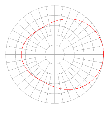 | ||||||||||||||||||
| Azimuth | Ratio | Azimuth | Ratio | Azimuth | Ratio | Azimuth | Ratio | ||||||||||||
| 0 | 0.673 | 10 | 0.720 | 20 | 0.773 | 30 | 0.827 | ||||||||||||
| 40 | 0.877 | 50 | 0.920 | 60 | 0.955 | 70 | 0.980 | ||||||||||||
| 80 | 0.996 | 90 | 1.000 | 100 | 0.994 | 110 | 0.976 | ||||||||||||
| 120 | 0.949 | 130 | 0.912 | 140 | 0.867 | 150 | 0.817 | ||||||||||||
| 160 | 0.763 | 170 | 0.710 | 180 | 0.664 | 190 | 0.627 | ||||||||||||
| 200 | 0.606 | 210 | 0.599 | 220 | 0.606 | 230 | 0.622 | ||||||||||||
| 240 | 0.641 | 250 | 0.658 | 260 | 0.670 | 270 | 0.674 | ||||||||||||
| 280 | 0.668 | 290 | 0.655 | 300 | 0.637 | 310 | 0.618 | ||||||||||||
| 320 | 0.604 | 330 | 0.599 | 340 | 0.609 | 350 | 0.633 | ||||||||||||
Structure Registration Number 1218752 Structure Type: TOWER Registered To: NRT Communications Group, LLC Structure Address: 2800 Loop 277 North Eagle, TX County Name: Maverick County ASR Issued: 02/02/2015 Site Elevation: 248 m (814 ft.) Structure Height: 79.9 m (262 ft.) Height Overall: 79.9 m (262 ft.) Overall Height AMSL: 327.9 m (1076 ft.) FAA Determination: 04/07/1989 FAA Study #: 88-ASW-1746-OE FAA Circular #: 70/7460-1G Paint & Light FAA Chapters: 3, 4, 5, 9 28-43-33.0 N 100-28-36.0 W (NAD 83) 28-43-32.1 N 100-28-34.7 W (Converted to NAD 27) |
4500 S. Flores St Ste. 104 San Antonio, TX 78214 Phone: 202-841-6358 Limited Liability Company | Title: Manager Date: 12/08/2023 Application Certifier NRT COMMUNICATIONS GROUP, LLC Nrt Communications Group, Llc 310 S. St. Mary's Street Ste. 955 San Antonio, TX 78205 Applicant Jim McPhetridge Wes Broadcast Consultants, Inc. 104 Woodmont Montgomery, TX 77356 Broadcast Engineer Francisco R. Montero, Esq. Fletcher, Heald & Hildreth, Plc 1300 North 17th Street 11th Floor Arlington, VA 22209 | |||||||||||||||||