
FCCInfo.com
A Service of Cavell, Mertz & Associates, Inc.
(855) FCC-INFO
|
|
|
Post-repack Channel 30 Virtual Channel 44 |
|
||||||||||||||||||||||
|
|
Repacking Information: Pre-Repack Channel: 49 Post-Repack Channel: 30 Post-Repack ERP: 694 kW Phase: 1 Completion Deadline: 11/30/2018 Find nearby TV Facilities Status: License Application Accepted: 11/28/2023 License Expires: 02/01/2022 File Number: -0000228523 FCC Website Links: LMS Facility Details This Application Other KPTH Applications Including Superseded Applications Mailing Address Correspondence for KPTH Correspondence related to application -0000228523 Service Contour - Open Street Map or USGS Map (41 dBu) Service Contour - KML / Google Earth (41 dBu) Public Inspection Files Rabbit Ears Info Search for KPTH Site Location: 42-35-12.0 N 96-13-19.0 W (NAD 83) Site Location: 42-35-12.0 N 96-13-17.9 W (Converted to NAD 27) ERP: 350 kW Polarization: Elliptically polarized HAAT: 515 m (1690 ft.) Electrical Beam Tilt: 0.5 degrees R/C AGL: 500.5 m (1642 ft.) R/C AMSL: 906.8 m (2975 ft.) Site Elevation: 406.3 m. (1333 ft.) Height Overall*: 605.9 m (1988 ft.) (* As Filed In This Application, may differ from ASR Data, Below.) Directional Antenna - Antenna Make/Model: Dielectric TFU-24WB/VP-R C160 Antenna ID: 1011283 Polarization: Elliptically polarized | ||||||||||||||||||||||||
| Antenna Data for Antenna Id: 1011283 KPTH DX File: -0000228523 Dielectric - TFU-24WB/VP-R C160 Service: DX Standard Pattern: N | 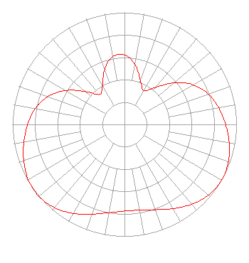 | ||||||||||||||||||||||||
| Azimuth | Ratio | Azimuth | Ratio | Azimuth | Ratio | Azimuth | Ratio | ||||||||||||||||||
| 0 | 0.622 | 10 | 0.542 | 20 | 0.415 | 30 | 0.347 | ||||||||||||||||||
| 40 | 0.430 | 50 | 0.579 | 60 | 0.708 | 70 | 0.796 | ||||||||||||||||||
| 80 | 0.854 | 90 | 0.902 | 100 | 0.948 | 110 | 0.986 | ||||||||||||||||||
| 120 | 1.000 | 130 | 0.981 | 140 | 0.932 | 150 | 0.868 | ||||||||||||||||||
| 160 | 0.811 | 170 | 0.778 | 180 | 0.774 | 190 | 0.801 | ||||||||||||||||||
| 200 | 0.853 | 210 | 0.917 | 220 | 0.971 | 230 | 0.998 | ||||||||||||||||||
| 240 | 0.991 | 250 | 0.957 | 260 | 0.912 | 270 | 0.864 | ||||||||||||||||||
| 280 | 0.809 | 290 | 0.727 | 300 | 0.605 | 310 | 0.455 | ||||||||||||||||||
| 320 | 0.349 | 330 | 0.391 | 340 | 0.518 | 350 | 0.613 | ||||||||||||||||||
Structure Registration Number 1057963 Structure Type: TOWER Registered To: Heartland Tower Company, L.L.C Structure Address: 1.6 Km Ne Of Rtes K42 And C70 Section 25 Plymouth County, IA County Name: Plymouth County ASR Issued: 08/24/2018 Date Built: 02/22/2007 Site Elevation: 406.3 m (1333 ft.) Structure Height: 563 m (1847 ft.) Height Overall: 605.9 m (1988 ft.) Overall Height AMSL: 1012.2 m (3321 ft.) FAA Determination: 02/21/2007 FAA Study #: 2007-ACE-85-OE FAA Circular #: 70/7460-1K Paint & Light FAA Chapters: 4, 7, 12 PRIOR STUDY 1998-ACE-1240-OE 42-35-12.0 N 96-13-19.0 W (NAD 83) 42-35-12.0 N 96-13-17.9 W (Converted to NAD 27) |
1200 Seventeenth Street Nw Washington, DC 20036 Phone: 202-663-8195 Limited Liability Company | Title: Cfo Date: 11/28/2023 Application Certifier KPTH Licensee, LLC Kpth Licensee, Llc 1200 Seventeenth Street Nw Washington, DC 20036 Applicant John E. Hidle, PE Carl T. Jones Corporation 7901 Yarnwood Court Springfield, VA 22153-2827 Consulting Engineer Paul A. Cicelski, Esq Lerman Senter, Pllc 2001 L. Street Nw Suite 400 Washington, DC 20036 Legal Representative | |||||||||||||||||||||||
| |||||||||||||||||||||||||