
FCCInfo.com
A Service of Cavell, Mertz & Associates, Inc.
(855) FCC-INFO
|
|
KKIF-LD from 07/12/2016 KKIF-LD from 06/20/2016 |
|
|
||||||||||||||||
|
|
Status: STA – Special Temporary Authority Application Accepted: 11/30/2023 STA Expires: 10/03/2022 File Number: -0000229820 FCC Website Links: LMS Facility Details This Application Other KKIF-LD Applications Including Superseded Applications Mailing Address Correspondence for KKIF-LD Correspondence related to application -0000229820 Service Contour - Open Street Map or USGS Map (51 dBu) Service Contour - KML / Google Earth (51 dBu) Rabbit Ears Info Search for KKIF-LD Site Location: 42-43-47.0 N 114-24-55.0 W (NAD 83) Site Location: 42-43-47.3 N 114-24-51.9 W (Converted to NAD 27) ERP: 15 kW Polarization: Elliptically polarized Electrical Beam Tilt: 1.05 degrees R/C AGL: 121.9 m (400 ft.) R/C AMSL: 1431.6 m (4697 ft.) Emission Mask: Full Service Site Elevation: 1309.7 m. (4297 ft.) Height Overall*: 207.8 m (682 ft.) (* As Filed In This Application, may differ from ASR Data, Below.) Directional Antenna - Antenna Make/Model: Dielectric TFU-8WB-LP/VP-R S230 Antenna ID: 1009070 Polarization: Elliptically polarized | ||||||||||||||||||
| Antenna Data for Antenna Id: 1009070 KKIF-LD LD File: -0000229820 Dielectric - TFU-8WB-LP/VP-R S230 Service: LD Standard Pattern: N Pattern and Field Values Include a 200° Clockwise Rotation | 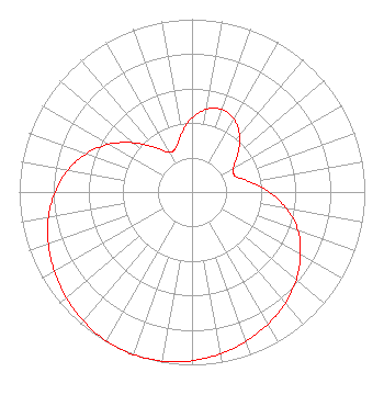 | ||||||||||||||||||
| Azimuth | Ratio | Azimuth | Ratio | Azimuth | Ratio | Azimuth | Ratio | ||||||||||||
| 0 | 0.428 | 10 | 0.487 | 20 | 0.508 | 30 | 0.487 | ||||||||||||
| 40 | 0.428 | 50 | 0.347 | 60 | 0.275 | 70 | 0.268 | ||||||||||||
| 80 | 0.340 | 90 | 0.447 | 100 | 0.556 | 110 | 0.652 | ||||||||||||
| 120 | 0.725 | 130 | 0.789 | 140 | 0.841 | 150 | 0.882 | ||||||||||||
| 160 | 0.918 | 170 | 0.950 | 180 | 0.976 | 190 | 0.993 | ||||||||||||
| 200 | 1.000 | 210 | 0.994 | 220 | 0.976 | 230 | 0.951 | ||||||||||||
| 240 | 0.920 | 250 | 0.884 | 260 | 0.843 | 270 | 0.793 | ||||||||||||
| 280 | 0.729 | 290 | 0.649 | 300 | 0.553 | 310 | 0.444 | ||||||||||||
| 320 | 0.337 | 330 | 0.265 | 340 | 0.273 | 350 | 0.345 | ||||||||||||
Structure Registration Number 1040035 Structure Type: TOWER Registered To: Gray Media Group, Inc. Structure Address: On Flat Top Butte, 5 Miles East Of Jerome, ID County Name: Jerome County ASR Issued: 09/09/2020 Date Built: 12/01/1961 Site Elevation: 1309.7 m (4297 ft.) Structure Height: 183.6 m (602 ft.) Height Overall: 207.8 m (682 ft.) Overall Height AMSL: 1517.5 m (4979 ft.) FAA Determination: 01/16/1998 FAA Study #: 98-ANM-0006-OE FAA Circular #: 70/7460-1J Paint & Light FAA Chapters: 3, 4, 5, 13 PRIOR FAA 91-ANM-0388-OE 42-43-47.0 N 114-24-55.0 W (NAD 83) 42-43-47.3 N 114-24-51.9 W (Converted to NAD 27) |
P.o. Box 15009 Fresno, CA 93702 Phone: 866-436-6388 Limited Liability Company | Title: Managing Member Date: 11/30/2023 Application Certifier VENTURA MEDIA COMMUNICATIONS, LLC Ventura Media Communications, Llc P.o. Box 15009 Fresno, CA 93702 Applicant Kathleen Victory Fletcher Heald & Hildreth, Plc 1300 N. 17th Street Suite 1100 Arlington, VA 22209 FCC Counsel | |||||||||||||||||
