
FCCInfo.com
A Service of Cavell, Mertz & Associates, Inc.
(855) FCC-INFO
|
|
|
|
|
||||||||||||||||
|
|
Status: License Application Accepted: 12/08/2023 License Expires: 08/01/2030 File Number: -0000232082 FCC Website Links: LMS Facility Details This Application Other KXXW-LD Applications Including Superseded Applications Mailing Address Correspondence for KXXW-LD Correspondence related to application -0000232082 Service Contour - Open Street Map or USGS Map (48 dBu) Service Contour - KML / Google Earth (48 dBu) Rabbit Ears Info Search for KXXW-LD Site Location: 32-15-34.0 N 95-22-04.0 W (NAD 83) Site Location: 32-15-33.5 N 95-22-03.2 W (Converted to NAD 27) ERP: 3 kW Polarization: Elliptically polarized R/C AGL: 112.8 m (370 ft.) R/C AMSL: 291.8 m (957 ft.) Emission Mask: Full Service Site Elevation: 179 m. (587 ft.) Height Overall*: 137 m (449 ft.) (* As Filed In This Application, may differ from ASR Data, Below.) Directional Antenna - Antenna Make/Model: Scala DRV Antenna ID: 95466 Polarization: Elliptically polarized | ||||||||||||||||||
| Antenna Data for Antenna Id: 95466 KXXW-LD LD File: -0000232082 Scala - DRV Service: LD Standard Pattern: Y Pattern and Field Values Include a 55° Clockwise Rotation | 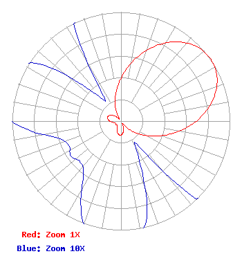 | ||||||||||||||||||
| Azimuth | Ratio | Azimuth | Ratio | Azimuth | Ratio | Azimuth | Ratio | ||||||||||||
| 5 | 0.465 | 15 | 0.617 | 25 | 0.764 | 35 | 0.888 | ||||||||||||
| 45 | 0.973 | 55 | 1.000 | 65 | 0.973 | 75 | 0.888 | ||||||||||||
| 85 | 0.764 | 95 | 0.617 | 105 | 0.465 | 115 | 0.325 | ||||||||||||
| 125 | 0.208 | 135 | 0.108 | 145 | 0.028 | 155 | 0.040 | ||||||||||||
| 165 | 0.091 | 175 | 0.120 | 185 | 0.129 | 195 | 0.115 | ||||||||||||
| 205 | 0.087 | 215 | 0.060 | 225 | 0.053 | 235 | 0.056 | ||||||||||||
| 245 | 0.053 | 255 | 0.060 | 265 | 0.087 | 275 | 0.115 | ||||||||||||
| 285 | 0.129 | 295 | 0.120 | 305 | 0.091 | 315 | 0.040 | ||||||||||||
| 325 | 0.028 | 335 | 0.108 | 345 | 0.208 | 355 | 0.325 | ||||||||||||
Structure Registration Number 1047032 Structure Type: Registered To: TerraPact Towers, LLC Structure Address: On Jonesville Rd .4 Km W Of Old Jacksonville Hwy Tyler, TX County Name: Smith County ASR Issued: 11/29/2023 Date Built: 08/12/1982 Site Elevation: 179 m (587 ft.) Structure Height: 131 m (430 ft.) Height Overall: 137 m (449 ft.) Overall Height AMSL: 316 m (1037 ft.) FAA Determination: 06/21/1982 FAA Study #: 82-ASW-1460-OE Paint & Light FAA Chapters: 1, 3, 12, 21 RED LIGHTS/PAINT 32-15-34.0 N 95-22-04.0 W (NAD 83) 32-15-33.5 N 95-22-03.2 W (Converted to NAD 27) |
888c 8th Avenue Suite 733 New York, NY 10019 Phone: 212-580-1349 Corporation | Title: President Date: 12/08/2023 Application Certifier Roseland Broadcasting, Inc. 888c 8th Avenue Suite 733 New York, NY 10019 Applicant Clarence M Beverage Communications Technologies 23 Binsted Drive Medford, NJ 08055 Broadcast Engineering Consultant Aaron P Shainis Shainis & Peltzman, Chartered 1850 M Street Nw Suite 240 Washington, DC 20036 FCC Legal Counsel | |||||||||||||||||