
FCCInfo.com
A Service of Cavell, Mertz & Associates, Inc.
(855) FCC-INFO
|
|
K30JM-D from 05/13/1997 K30JM-D from 02/11/1997 K30JM-D from 01/11/1988 K30JM-D from 05/19/1992 K30JM-D from 10/18/1991 K30JM-D from 03/06/1987 |
|
|
||||||||||||||||||||||
|
|
Status: License Application Accepted: 12/13/2023 License Expires: 04/01/2030 File Number: -0000232639 FCC Website Links: LMS Facility Details This Application Other K30JM-D Applications Including Superseded Applications Mailing Address Correspondence for K30JM-D Correspondence related to application -0000232639 Service Contour - Open Street Map or USGS Map (51 dBu) Service Contour - KML / Google Earth (51 dBu) Rabbit Ears Info Search for K30JM-D Site Location: 38-44-45.0 N 104-51-41.0 W (NAD 83) Site Location: 38-44-45.0 N 104-51-39.1 W (Converted to NAD 27) ERP: 11.2 kW Polarization: Elliptically polarized Electrical Beam Tilt: 0.5 degrees R/C AGL: 27 m (89 ft.) R/C AMSL: 2894 m (9495 ft.) Emission Mask: Full Service Site Elevation: 2867 m. (9406 ft.) Height Overall*: 28.3 m (93 ft.) (* As Filed In This Application, may differ from ASR Data, Below.) Directional Antenna - Antenna Make/Model: Kathrein 750 10300 Antenna ID: 1011318 Polarization: Elliptically polarized | ||||||||||||||||||||||||
| Antenna Data for Antenna Id: 1011318 K30JM-D LD File: -0000232639 Kathrein - 750 10300 Service: LD Standard Pattern: N | 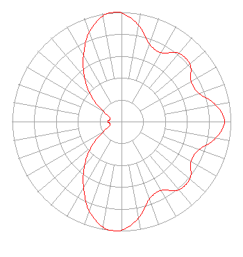 | ||||||||||||||||||||||||
| Azimuth | Ratio | Azimuth | Ratio | Azimuth | Ratio | Azimuth | Ratio | ||||||||||||||||||
| 0 | 0.991 | 10 | 0.894 | 20 | 0.751 | 30 | 0.727 | ||||||||||||||||||
| 40 | 0.814 | 50 | 0.816 | 60 | 0.735 | 70 | 0.753 | ||||||||||||||||||
| 80 | 0.876 | 90 | 0.942 | 100 | 0.876 | 110 | 0.753 | ||||||||||||||||||
| 120 | 0.735 | 130 | 0.816 | 140 | 0.814 | 150 | 0.727 | ||||||||||||||||||
| 160 | 0.751 | 170 | 0.895 | 180 | 0.991 | 183 | 1.000 | ||||||||||||||||||
| 184 | 1.000 | 190 | 0.979 | 200 | 0.866 | 210 | 0.695 | ||||||||||||||||||
| 220 | 0.526 | 230 | 0.360 | 240 | 0.197 | 250 | 0.115 | ||||||||||||||||||
| 260 | 0.109 | 270 | 0.124 | 280 | 0.109 | 290 | 0.115 | ||||||||||||||||||
| 300 | 0.197 | 310 | 0.360 | 320 | 0.526 | 330 | 0.695 | ||||||||||||||||||
| 340 | 0.865 | 350 | 0.979 | 356 | 1.000 | 357 | 1.000 | ||||||||||||||||||
Structure Registration Number 1054001 Structure Type: TOWER Registered To: Scripps Broadcasting Holdings LLC Structure Address: Approx 10.6 Km Cheyenne Mountain Ssw Colorado Springs, CO County Name: El Paso County ASR Issued: 05/02/2019 Date Built: 01/01/1980 Site Elevation: 2867 m (9406 ft.) Structure Height: 25.9 m (85 ft.) Height Overall: 28.3 m (93 ft.) Overall Height AMSL: 2895.3 m (9499 ft.) Paint & Light FAA Chapters: None 38-44-45.0 N 104-51-41.0 W (NAD 83) 38-44-45.0 N 104-51-39.1 W (Converted to NAD 27) |
C/o Scripps Media, Inc. 312 Walnut Street, 28th Floor Cincinnati, OH 45202 Phone: 513-977-3000 Limited Liability Company | Title: Vice President Date: 12/13/2023 Application Certifier Scripps Broadcasting Holdings Llc C/o Scripps Media, Inc. 312 Walnut Street, 28th Floor Cincinnati, OH 45202 Applicant Coe W. Ramsey Brooks, Pierce Et Al. 150 Fayetteville Street Suite 1700 Raleigh, NC 27601 | |||||||||||||||||||||||
| |||||||||||||||||||||||||
