
FCCInfo.com
A Service of Cavell, Mertz & Associates, Inc.
(855) FCC-INFO
|
|
W34FO-D from 12/13/2010 |
|
|
||||||||||||||||
|
|
Status: Construction Permit Application Accepted: 01/03/2024 W34FO-D CP Expires: 01/09/2027 File Number: -0000234750 FCC Website Links: LMS Facility Details This Application Other W34FO-D Applications Including Superseded Applications Mailing Address Correspondence for W34FO-D Correspondence related to application -0000234750 Service Contour - Open Street Map or USGS Map (51 dBu) Service Contour - KML / Google Earth (51 dBu) Rabbit Ears Info Search for W34FO-D Site Location: 33-15-02.6 N 82-24-48.9 W (NAD 83) Site Location: 33-15-02.1 N 82-24-49.4 W (Converted to NAD 27) ERP: 0.2 kW Polarization: Horizontally polarized R/C AGL: 6 m (20 ft.) R/C AMSL: 149.6 m (491 ft.) Emission Mask: Simple Site Elevation: 143.6 m. (471 ft.) Height Overall*: 124.9 m (410 ft.) (* As Filed In This Application, may differ from ASR Data, Below.) Directional Antenna - Antenna Make/Model: Scala CL-1469 Antenna ID: 20778 Polarization: Horizontally polarized | ||||||||||||||||||
| Antenna Data for Antenna Id: 20778 W34FO-D LD File: -0000234750 Scala - CL-1469 Service: LD Standard Pattern: Y Pattern and Field Values Include a 270° Clockwise Rotation | 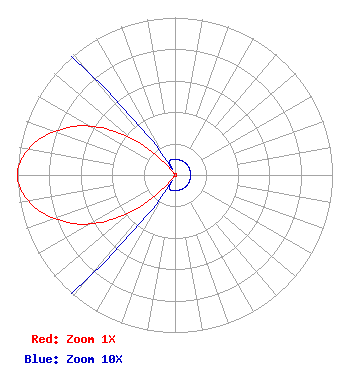 | ||||||||||||||||||
| Azimuth | Ratio | Azimuth | Ratio | Azimuth | Ratio | Azimuth | Ratio | ||||||||||||
| 0 | 0.010 | 10 | 0.010 | 20 | 0.010 | 30 | 0.010 | ||||||||||||
| 40 | 0.010 | 50 | 0.010 | 60 | 0.010 | 70 | 0.010 | ||||||||||||
| 80 | 0.010 | 90 | 0.010 | 100 | 0.010 | 110 | 0.010 | ||||||||||||
| 120 | 0.010 | 130 | 0.010 | 140 | 0.010 | 150 | 0.010 | ||||||||||||
| 160 | 0.010 | 170 | 0.010 | 180 | 0.010 | 190 | 0.010 | ||||||||||||
| 200 | 0.010 | 210 | 0.010 | 220 | 0.086 | 230 | 0.361 | ||||||||||||
| 240 | 0.622 | 250 | 0.812 | 260 | 0.947 | 270 | 1.000 | ||||||||||||
| 280 | 0.947 | 290 | 0.812 | 300 | 0.622 | 310 | 0.361 | ||||||||||||
| 320 | 0.086 | 330 | 0.010 | 340 | 0.010 | 350 | 0.010 | ||||||||||||
Structure Registration Number 1019958 Structure Type: GTOWER Registered To: Pinnacle Towers Acquisition LLC Structure Address: 4353 Highway 17 North Wrens, GA County Name: Jefferson County ASR Issued: 02/14/2024 Date Built: 10/01/1986 Site Elevation: 143.6 m (471 ft.) Structure Height: 122.2 m (401 ft.) Height Overall: 124.9 m (410 ft.) Overall Height AMSL: 268.5 m (881 ft.) FAA Determination: 09/30/2019 FAA Study #: 2019-ASO-27006-OE FAA Circular #: 70/7460-1L Paint & Light FAA Chapters: 4, 8, 12 33-15-02.6 N 82-24-48.9 W (NAD 83) 33-15-02.1 N 82-24-49.4 W (Converted to NAD 27) |
1498 Buford Hwy Ste C 275 Sugar Hill, GA 30518 Phone: 770-771-1644 Limited Liability Company | Title: President Date: 01/03/2024 Application Certifier DTV INNOVATORS, INC. Dtv Innovators, Inc. 1498 Buford Hwy Ste C 275 Sugar Hill, GA 30518 Applicant Susan Hansen B. W. St. Clair 2305 Vida Shaw Rd New Iberia, LA 70563 CONSULTANT Kathleen Victory Fletcher Heald & Hildreth, Plc 1300 N 17th St Suite 1100 Arlington, VA 22209 | |||||||||||||||||