
FCCInfo.com
A Service of Cavell, Mertz & Associates, Inc.
(855) FCC-INFO
|
|
from 04/10/2012 from 09/23/1992 |
|
|
||||||||||||||||
|
|
Status: License Application Accepted: 01/05/2024 License Expires: 06/01/2029 File Number: -0000234895 FCC Website Links: LMS Facility Details This Application Other WMEL-LD Applications Including Superseded Applications Mailing Address Correspondence for WMEL-LD Correspondence related to application -0000234895 Service Contour - Open Street Map or USGS Map (48 dBu) Service Contour - KML / Google Earth (48 dBu) Rabbit Ears Info Search for WMEL-LD Site Location: 33-32-21.0 N 90-02-08.0 W (NAD 83) Site Location: 33-32-20.6 N 90-02-07.7 W (Converted to NAD 27) ERP: 2.34 kW Polarization: Elliptically polarized Electrical Beam Tilt: 0.5 degrees R/C AGL: 86.9 m (285 ft.) R/C AMSL: 193.5 m (635 ft.) Emission Mask: Simple Site Elevation: 106.6 m. (350 ft.) Height Overall*: 121.9 m (400 ft.) (* As Filed In This Application, may differ from ASR Data, Below.) Directional Antenna - Antenna Make/Model: Jampro JSL-4V / D13 SEC Antenna ID: 1011377 Polarization: Elliptically polarized | ||||||||||||||||||
| Antenna Data for Antenna Id: 1011377 WMEL-LD LD File: -0000234895 Jampro - JSL-4V / D13 SEC Service: LD Standard Pattern: N Pattern and Field Values Include a 342° Clockwise Rotation | 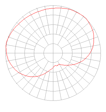 | ||||||||||||||||||
| Azimuth | Ratio | Azimuth | Ratio | Azimuth | Ratio | Azimuth | Ratio | ||||||||||||
| 2 | 0.940 | 12 | 0.960 | 22 | 0.980 | 32 | 0.990 | ||||||||||||
| 42 | 1.000 | 52 | 0.980 | 62 | 0.950 | 72 | 0.900 | ||||||||||||
| 82 | 0.840 | 92 | 0.760 | 102 | 0.670 | 112 | 0.570 | ||||||||||||
| 122 | 0.470 | 132 | 0.380 | 142 | 0.320 | 152 | 0.270 | ||||||||||||
| 162 | 0.280 | 172 | 0.270 | 182 | 0.320 | 192 | 0.380 | ||||||||||||
| 202 | 0.470 | 212 | 0.570 | 222 | 0.670 | 232 | 0.760 | ||||||||||||
| 242 | 0.840 | 252 | 0.900 | 262 | 0.950 | 272 | 0.980 | ||||||||||||
| 282 | 1.000 | 292 | 0.980 | 302 | 0.960 | 312 | 0.940 | ||||||||||||
| 322 | 0.930 | 332 | 0.920 | 342 | 0.920 | 352 | 0.930 | ||||||||||||
Structure Registration Number 1041937 Structure Type: TOWER Registered To: LEFLORE COMMUNICATIONS INC Structure Address: Malmaison Rd Greenwood, MS County Name: Carroll County ASR Issued: 03/27/1998 Date Built: 01/01/1976 Site Elevation: 106.6 m (350 ft.) Structure Height: 121.9 m (400 ft.) Height Overall: 121.9 m (400 ft.) Overall Height AMSL: 228.5 m (750 ft.) FAA Determination: 10/19/1976 FAA Study #: 76-SO-1850-OE Paint & Light FAA Chapters: 1, 3, 12, 21 RED LIGHTS/PAINT 33-32-21.0 N 90-02-08.0 W (NAD 83) 33-32-20.6 N 90-02-07.7 W (Converted to NAD 27) |
619 Aubrey Circle South Greenwood, MS 38930 Phone: 662-822-1655 Limited Liability Company | Title: Member Date: 01/05/2024 Application Certifier Legacy Broadcasting Of Ms 619 Aubrey Circle South Greenwood, MS 38930 Applicant F. Scott Pippin Lerman Senter Pllc 2001 L Street, Nw Suite 400 Washington, DC 20036 Attorney Scott Turpie Lohnes & Culver, Llc Alexandria, VA 22302 Sr. Technical Consultant | |||||||||||||||||