
FCCInfo.com
A Service of Cavell, Mertz & Associates, Inc.
(855) FCC-INFO
|
|
|
Virtual Channel 19 |  |
|
|||||||||||||||
|
|
Repacking Information: No changes Status: STA – Special Temporary Authority (Licensed And Silent) Application Accepted: 01/24/2024 STA Expires: 06/29/2024 File Number: -0000236247 FCC Website Links: LMS Facility Details This Application Other KJRE Applications Including Superseded Applications Mailing Address Correspondence for KJRE Correspondence related to application -0000236247 Service Contour - Open Street Map or USGS Map (41 dBu) Service Contour - KML / Google Earth (41 dBu) Public Inspection Files Rabbit Ears Info Search for KJRE Site Location: 46-17-56.0 N 98-51-57.0 W (NAD 83) Site Location: 46-17-56.1 N 98-51-55.6 W (Converted to NAD 27) ERP: 72.3 kW Polarization: Horizontally polarized HAAT: 162.5 m (533 ft.) Electrical Beam Tilt: 0.75 degrees R/C AGL: 140 m (459 ft.) R/C AMSL: 740.5 m (2429 ft.) Site Elevation: 600.5 m. (1970 ft.) Height Overall*: 152.4 m (500 ft.) (* As Filed In This Application, may differ from ASR Data, Below.) Directional Antenna - Antenna Make/Model: Andrew ALP32L3-HSW Antenna ID: 64873 Polarization: Horizontally polarized | ||||||||||||||||||
| Antenna Data for Antenna Id: 64873 KJRE DT File: -0000236247 Andrew - ALP32L3-HSW Service: DT Standard Pattern: Y | 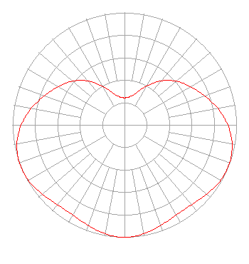 | ||||||||||||||||||
| Azimuth | Ratio | Azimuth | Ratio | Azimuth | Ratio | Azimuth | Ratio | ||||||||||||
| 0 | 0.241 | 10 | 0.253 | 20 | 0.302 | 30 | 0.397 | ||||||||||||
| 40 | 0.510 | 50 | 0.605 | 60 | 0.680 | 70 | 0.758 | ||||||||||||
| 80 | 0.845 | 90 | 0.922 | 100 | 0.975 | 110 | 0.997 | ||||||||||||
| 120 | 0.990 | 130 | 0.959 | 140 | 0.929 | 150 | 0.925 | ||||||||||||
| 160 | 0.951 | 170 | 0.985 | 180 | 1.000 | 190 | 0.985 | ||||||||||||
| 200 | 0.951 | 210 | 0.925 | 220 | 0.929 | 230 | 0.959 | ||||||||||||
| 240 | 0.990 | 250 | 0.997 | 260 | 0.975 | 270 | 0.922 | ||||||||||||
| 280 | 0.845 | 290 | 0.758 | 300 | 0.680 | 310 | 0.605 | ||||||||||||
| 320 | 0.510 | 330 | 0.397 | 340 | 0.302 | 350 | 0.253 | ||||||||||||
Structure Registration Number 1038022 Structure Type: TOWER Registered To: Prairie Public Broadcasting, Inc. Structure Address: 6.4 Km E Kulm, ND County Name: LaMoure County ASR Issued: 03/16/2012 Date Built: 12/20/1991 Site Elevation: 600.5 m (1970 ft.) Structure Height: 152.4 m (500 ft.) Height Overall: 152.4 m (500 ft.) Overall Height AMSL: 752.9 m (2470 ft.) FAA Determination: 10/24/1997 FAA Study #: 97-AGL-4739-OE FAA Circular #: 70/7460-1J Paint & Light FAA Chapters: 4, 6, 13 46-17-56.0 N 98-51-57.0 W (NAD 83) 46-17-56.1 N 98-51-55.6 W (Converted to NAD 27) |
Fargo, ND 58108 Phone: 701-241-6900 Not-for-Profit | Title: Director Of Engineering Date: 01/24/2024 Application Certifier Prairie Public Broadcasting, Inc. Fargo, ND 58108 Applicant Jack W Anderson Prairie Public Broadcasting, Inc. Fargo, ND 58108 Director of Engineering Barry Persh Gray Miller Persh Llp 2233 Wisconsin Ave., Nw Suite 226 Washington, DC 20007 | |||||||||||||||||
| |||||||||||||||||||