
FCCInfo.com
A Service of Cavell, Mertz & Associates, Inc.
(855) FCC-INFO
|
|
KEYU from 02/06/1998 |
Virtual Channel 31 |  |
|
|||||||||||||||
|
|
Repacking Information: No changes Status: License Application Accepted: 02/06/2024 License Expires: 08/01/2030 File Number: -0000238380 FCC Website Links: LMS Facility Details This Application Other KEYU Applications Including Superseded Applications Mailing Address Correspondence for KEYU Correspondence related to application -0000238380 Service Contour - Open Street Map or USGS Map (41 dBu) Service Contour - KML / Google Earth (41 dBu) Public Inspection Files Rabbit Ears Info Search for KEYU Site Location: 35-17-34.2 N 101-50-43.4 W (NAD 83) Site Location: 35-17-34.0 N 101-50-41.7 W (Converted to NAD 27) ERP: 700 kW Polarization: Elliptically polarized HAAT: 429.7 m (1410 ft.) Electrical Beam Tilt: 0.75 degrees R/C AGL: 407.4 m (1337 ft.) R/C AMSL: 1489.7 m (4887 ft.) Site Elevation: 1082.3 m. (3551 ft.) Height Overall*: 456 m (1496 ft.) (* As Filed In This Application, may differ from ASR Data, Below.) Directional Antenna - Antenna Make/Model: Dielectric TFU-26EST/VP-R 4C150 Antenna ID: 1011453 Polarization: Elliptically polarized | ||||||||||||||||||
| Antenna Data for Antenna Id: 1011453 KEYU DT File: -0000238380 Dielectric - TFU-26EST/VP-R 4C150 Service: DT Standard Pattern: N | 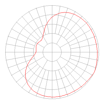 | ||||||||||||||||||
| Azimuth | Ratio | Azimuth | Ratio | Azimuth | Ratio | Azimuth | Ratio | ||||||||||||
| 0 | 0.743 | 10 | 0.836 | 20 | 0.899 | 30 | 0.933 | ||||||||||||
| 40 | 0.951 | 50 | 0.960 | 60 | 0.961 | 70 | 0.960 | ||||||||||||
| 80 | 0.961 | 90 | 0.968 | 100 | 0.976 | 110 | 0.990 | ||||||||||||
| 115 | 1.000 | 120 | 0.990 | 130 | 0.976 | 140 | 0.968 | ||||||||||||
| 150 | 0.961 | 160 | 0.960 | 170 | 0.961 | 180 | 0.960 | ||||||||||||
| 190 | 0.951 | 200 | 0.933 | 210 | 0.899 | 220 | 0.836 | ||||||||||||
| 230 | 0.743 | 240 | 0.617 | 250 | 0.486 | 260 | 0.386 | ||||||||||||
| 270 | 0.342 | 280 | 0.347 | 290 | 0.360 | 300 | 0.360 | ||||||||||||
| 310 | 0.347 | 320 | 0.342 | 330 | 0.386 | 340 | 0.486 | ||||||||||||
| 350 | 0.617 | ||||||||||||||||||
Structure Registration Number 1052115 Structure Type: GTOWER Registered To: Gray Media Group, Inc. Structure Address: 7900 Broadway Amarillo, TX County Name: Potter County ASR Issued: 07/31/2023 Date Built: 08/09/2023 Site Elevation: 1082.3 m (3551 ft.) Structure Height: 427 m (1401 ft.) Height Overall: 456 m (1496 ft.) Overall Height AMSL: 1538.3 m (5047 ft.) FAA Determination: 05/15/2023 FAA Study #: 2023-ASW-4341-OE FAA Circular #: 70/7460-1M Paint & Light FAA Chapters: 4, 9, 15 PRIOR STUDY 1998-ASW-1905-OE 35-17-34.2 N 101-50-43.4 W (NAD 83) 35-17-34.0 N 101-50-41.7 W (Converted to NAD 27) |
4370 Peachtree Road, Ne Atlanta, GA 30319 Phone: 404-504-9828 Limited Liability Company | Title: Assistant Secretary Date: 02/06/2024 Application Certifier Gray Television Licensee, Llc 4370 Peachtree Road, Ne Atlanta, GA 30319 Applicant David Burke Gray Television Licensee, Llp 201 Monroe Street Rsa Tower, 20th Floor Montgomery, AL 36104 Senior Vice President and CTO Joseph M. Davis, P.E. Chesapeake Rf Consultants, Llc 207 Old Dominion Road Yorktown, VA 23692 Consulting Engineer Joan Stewart Wiley Rein Llp 2050 M Street, Nw Washington, DC 20036 | |||||||||||||||||