
FCCInfo.com
A Service of Cavell, Mertz & Associates, Inc.
(855) FCC-INFO
|
|
WLOV-TV from 01/22/1981 |
Virtual Channel 27 |  |
|
||||||||||||||||||||||||
|
|
Repacking Information: No changes Status: STA – Special Temporary Authority Application Accepted: 02/09/2024 STA Expires: 08/12/2024 File Number: -0000238657 FCC Website Links: LMS Facility Details This Application Other WLOV-TV Applications Including Superseded Applications Mailing Address Correspondence for WLOV-TV Correspondence related to application -0000238657 Service Contour - Open Street Map or USGS Map (41 dBu) Service Contour - KML / Google Earth (41 dBu) Public Inspection Files Rabbit Ears Info Search for WLOV-TV Site Location: 33-45-06.0 N 88-52-40.0 W (NAD 83) Site Location: 33-45-05.6 N 88-52-39.8 W (Converted to NAD 27) ERP: 3.13 kW Polarization: Horizontally polarized HAAT: 186.4 m (612 ft.) R/C AGL: 114.6 m (376 ft.) R/C AMSL: 270 m (886 ft.) Site Elevation: 155.4 m. (510 ft.) Height Overall*: 548.6 m (1800 ft.) (* As Filed In This Application, may differ from ASR Data, Below.) Directional Antenna - Antenna Make/Model: Systems With Reliability Inc. SWDDP 4-4-4-0/16 Antenna ID: 1011444 Polarization: Horizontally polarized | |||||||||||||||||||||||||||
| Antenna Data for Antenna Id: 1011444 WLOV-TV DT File: -0000238657 Systems With Reliability Inc. - SWDDP 4-4-4-0/16 Service: DT Standard Pattern: Y | 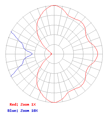 | |||||||||||||||||||||||||||
| Azimuth | Ratio | Azimuth | Ratio | Azimuth | Ratio | Azimuth | Ratio | |||||||||||||||||||||
| 0 | 1.000 | 10 | 0.947 | 20 | 0.847 | 30 | 0.840 | |||||||||||||||||||||
| 40 | 0.865 | 50 | 0.832 | 60 | 0.761 | 70 | 0.762 | |||||||||||||||||||||
| 80 | 0.850 | 90 | 0.899 | 100 | 0.850 | 110 | 0.762 | |||||||||||||||||||||
| 120 | 0.761 | 130 | 0.832 | 140 | 0.865 | 150 | 0.840 | |||||||||||||||||||||
| 160 | 0.847 | 170 | 0.947 | 180 | 1.000 | 190 | 0.939 | |||||||||||||||||||||
| 200 | 0.827 | 210 | 0.700 | 220 | 0.523 | 230 | 0.311 | |||||||||||||||||||||
| 240 | 0.125 | 250 | 0.074 | 260 | 0.062 | 270 | 0.045 | |||||||||||||||||||||
| 280 | 0.062 | 290 | 0.074 | 300 | 0.125 | 310 | 0.311 | |||||||||||||||||||||
| 320 | 0.523 | 330 | 0.700 | 340 | 0.827 | 350 | 0.939 | |||||||||||||||||||||
Structure Registration Number 1041013 Structure Type: TOWER Registered To: COLUMBUS TELEVISION, INC. Structure Address: 4.0 Mile Northeast Of Montpelier Columbus, MS County Name: Clay County ASR Issued: 03/17/1998 Date Built: 01/01/1985 Site Elevation: 155.4 m (510 ft.) Structure Height: 519.6 m (1705 ft.) Height Overall: 548.6 m (1800 ft.) Overall Height AMSL: 704 m (2310 ft.) FAA Determination: 02/13/1998 FAA Study #: 98-ASO-0649-OE FAA Circular #: 70/7460-1J Paint & Light FAA Chapters: 4, 7, 13 33-45-06.0 N 88-52-40.0 W (NAD 83) 33-45-05.6 N 88-52-39.8 W (Converted to NAD 27) |
2750 Luberon Lane Cumming, GA 30041 Phone: 678-777-8659 Limited Liability Company | Title: Ceo Date: 02/09/2024 Application Certifier COASTAL TELEVISION BROADCASTING COMPANY LLC Wlov License Llc 2750 Luberon Lane Cumming, GA 30041 Applicant Daniel Kirkpatrick Baker & Hostetler Llp 1050 Connecticut Avenue, Nw Suite 1100 Washington, DC 20036 | ||||||||||||||||||||||||||
| ||||||||||||||||||||||||||||