
FCCInfo.com
A Service of Cavell, Mertz & Associates, Inc.
(855) FCC-INFO
|
|
WLNM-LD from 07/08/2009 WLNM-LD from 11/25/2003 WLNM-LD from 11/25/1986 |
|
|
||||||||||||||||
|
|
Status: Application Application Accepted: 02/29/2024 License Expires: 10/01/2021 File Number: -0000240084 FCC Website Links: LMS Facility Details This Application Other WLNM-LD Applications Including Superseded Applications Mailing Address Correspondence for WLNM-LD Correspondence related to application -0000240084 Service Contour - Open Street Map or USGS Map (51 dBu) Service Contour - KML / Google Earth (51 dBu) Rabbit Ears Info Search for WLNM-LD Site Location: 42-42-06.9 N 84-24-47.8 W (NAD 83) Site Location: 42-42-06.8 N 84-24-47.9 W (Converted to NAD 27) ERP: 15 kW Polarization: Elliptically polarized Electrical Beam Tilt: 1.0 degree R/C AGL: 249.9 m (820 ft.) R/C AMSL: 509 m (1670 ft.) Emission Mask: Full Service Site Elevation: 259.1 m. (850 ft.) Height Overall*: 313.3 m (1028 ft.) (* As Filed In This Application, may differ from ASR Data, Below.) Directional Antenna - Antenna Make/Model: Dielectric TLP-12W/VP Antenna ID: 1011518 Polarization: Elliptically polarized | ||||||||||||||||||
| Antenna Data for Antenna Id: 1011518 WLNM-LD LD File: -0000240084 Dielectric - TLP-12W/VP Service: LD Standard Pattern: N Pattern and Field Values Include a 270° Clockwise Rotation | 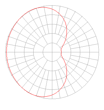 | ||||||||||||||||||
| Azimuth | Ratio | Azimuth | Ratio | Azimuth | Ratio | Azimuth | Ratio | ||||||||||||
| 0 | 0.918 | 10 | 0.841 | 20 | 0.739 | 30 | 0.617 | ||||||||||||
| 40 | 0.488 | 50 | 0.365 | 60 | 0.268 | 70 | 0.214 | ||||||||||||
| 80 | 0.199 | 90 | 0.199 | 100 | 0.199 | 110 | 0.214 | ||||||||||||
| 120 | 0.268 | 130 | 0.365 | 140 | 0.488 | 150 | 0.617 | ||||||||||||
| 160 | 0.739 | 170 | 0.841 | 180 | 0.918 | 190 | 0.968 | ||||||||||||
| 200 | 0.993 | 210 | 1.000 | 220 | 0.995 | 230 | 0.986 | ||||||||||||
| 240 | 0.978 | 250 | 0.974 | 260 | 0.972 | 270 | 0.972 | ||||||||||||
| 280 | 0.972 | 290 | 0.974 | 300 | 0.978 | 310 | 0.986 | ||||||||||||
| 320 | 0.995 | 330 | 1.000 | 340 | 0.993 | 350 | 0.968 | ||||||||||||
Structure Registration Number 1265362 Structure Type: TOWER Registered To: Board of Trustees, Michigan State University Structure Address: 4101 Dobie Road Okemos, MI County Name: Ingham County ASR Issued: 12/22/2011 Date Built: 07/05/2011 Site Elevation: 259.1 m (850 ft.) Structure Height: 297.8 m (977 ft.) Height Overall: 313.3 m (1028 ft.) Overall Height AMSL: 572.4 m (1878 ft.) FAA Determination: 12/08/2011 FAA Study #: 2011-AGL-4543-OE FAA Circular #: 70/7460-1K Paint & Light FAA Chapters: 3, 4, 5, 12 PRIOR STUDY 2008-AGL-4484-OE 42-42-06.9 N 84-24-47.8 W (NAD 83) 42-42-06.8 N 84-24-47.9 W (Converted to NAD 27) |
4370 Peachtree Rd, Ne Atlanta, GA 30319 Phone: 404-266-8333 Limited Liability Company | Title: Assistant Secretary Date: 02/29/2024 Application Certifier Gray Television Licensee, Llc 4370 Peachtree Rd, Ne Atlanta, GA 30319 Applicant Joseph M. Davis, P.E. Chesapeake Rf Consultants, Llc 207 Old Dominion Road Yorktown, VA 23692 Consulting Engineer Joan Stewart Wiley Rein Llp 2050 M Street, Nw Washington, DC 20036 | |||||||||||||||||