
FCCInfo.com
A Service of Cavell, Mertz & Associates, Inc.
(855) FCC-INFO
|
|
K27OW-D from 05/29/2007 K27OW-D from 02/01/2002 |
|
|
||||||||||||||||
|
|
Status: Construction Permit Application Accepted: 03/04/2024 K27OW-D CP Expires: 03/02/2026 File Number: -0000240349 FCC Website Links: LMS Facility Details This Application Other K27OW-D Applications Including Superseded Applications Mailing Address Correspondence for K27OW-D Correspondence related to application -0000240349 Service Contour - Open Street Map or USGS Map (51 dBu) Service Contour - KML / Google Earth (51 dBu) Rabbit Ears Info Search for K27OW-D Site Location: 44-01-28.0 N 92-32-42.0 W (NAD 83) Site Location: 44-01-28.1 N 92-32-41.4 W (Converted to NAD 27) ERP: 15 kW Polarization: Horizontally polarized R/C AGL: 45.7 m (150 ft.) R/C AMSL: 411.7 m (1351 ft.) Emission Mask: Full Service Site Elevation: 366 m. (1201 ft.) Height Overall*: 108 m (354 ft.) (* As Filed In This Application, may differ from ASR Data, Below.) Directional Antenna - Antenna Make/Model: Propagation System Inc PSILP8EC Antenna ID: 1011534 Polarization: Horizontally polarized | ||||||||||||||||||
| Antenna Data for Antenna Id: 1011534 K27OW-D LD File: -0000240349 Propagation System Inc - PSILP8EC Service: LD Standard Pattern: N Pattern and Field Values Include a 175.0° Clockwise Rotation | 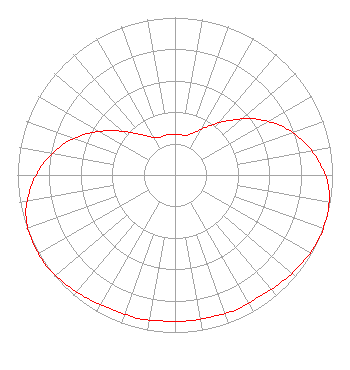 | ||||||||||||||||||
| Azimuth | Ratio | Azimuth | Ratio | Azimuth | Ratio | Azimuth | Ratio | ||||||||||||
| 5 | 0.260 | 15 | 0.260 | 25 | 0.300 | 35 | 0.380 | ||||||||||||
| 45 | 0.490 | 55 | 0.620 | 65 | 0.740 | 75 | 0.840 | ||||||||||||
| 85 | 0.920 | 95 | 0.980 | 105 | 1.000 | 115 | 1.000 | ||||||||||||
| 125 | 0.980 | 135 | 0.960 | 145 | 0.940 | 155 | 0.940 | ||||||||||||
| 165 | 0.930 | 175 | 0.930 | 185 | 0.930 | 195 | 0.940 | ||||||||||||
| 205 | 0.940 | 215 | 0.960 | 225 | 0.980 | 235 | 1.000 | ||||||||||||
| 245 | 1.000 | 255 | 0.980 | 265 | 0.920 | 275 | 0.840 | ||||||||||||
| 285 | 0.740 | 295 | 0.620 | 305 | 0.490 | 315 | 0.380 | ||||||||||||
| 325 | 0.300 | 335 | 0.260 | 345 | 0.260 | 355 | 0.260 | ||||||||||||
Structure Registration Number 1022166 Structure Type: TOWER Registered To: BROGAN HEATING AND AIR CONDITIONING Structure Address: X5315 W Country Club Rd Rochester, MN County Name: Olmsted County ASR Issued: 06/13/1997 Date Built: 01/01/1966 Site Elevation: 366 m (1201 ft.) Structure Height: 108 m (354 ft.) Height Overall: 108 m (354 ft.) Overall Height AMSL: 474 m (1555 ft.) FAA Determination: 01/01/1966 FAA Study #: 66-MSP-6629 FAA Circular #: Paint & Light FAA Chapters: 1, 3, 12, 21 RED LIGHTS/PAINT 44-01-28.0 N 92-32-42.0 W (NAD 83) 44-01-28.1 N 92-32-41.4 W (Converted to NAD 27) |
Chattanooga, TN 37401 Phone: 423-468-5100 Limited Liability Company | Title: Coo Date: 03/04/2024 Application Certifier DIGITAL NETWORKS-MIDWEST, LLC Digital Networks-midwest, Llc Chattanooga, TN 37401 Applicant Timothy Z Sawyer T Z Sawyer Technical Consultants 2130 Hutchison Grove Court Suite 100 Falls Church, VA 22043 Technical Consultant Aaron P Shainis Shainis & Peltzman, Chartered 1850 M St. Nw Suite 240 Washington, DC 20036 FCC Legal Counsel | |||||||||||||||||