
FCCInfo.com
A Service of Cavell, Mertz & Associates, Inc.
(855) FCC-INFO
|
|
W34FF-D from 01/09/2003 |
|
|
||||||||||||||||
|
|
Status: License Application Accepted: 03/06/2024 License Expires: 02/01/2029 File Number: -0000240442 FCC Website Links: LMS Facility Details This Application Other W34FF-D Applications Including Superseded Applications Mailing Address Correspondence for W34FF-D Correspondence related to application -0000240442 Service Contour - Open Street Map or USGS Map (51 dBu) Service Contour - KML / Google Earth (51 dBu) Rabbit Ears Info Search for W34FF-D Site Location: 30-26-00.0 N 85-24-51.0 W (NAD 83) Site Location: 30-25-59.3 N 85-24-51.3 W (Converted to NAD 27) ERP: 15 kW Polarization: Elliptically polarized Electrical Beam Tilt: 0.5 degrees R/C AGL: 115.2 m (378 ft.) R/C AMSL: 157.3 m (516 ft.) Emission Mask: Full Service Site Elevation: 42.1 m. (138 ft.) Height Overall*: 247.5 m (812 ft.) (* As Filed In This Application, may differ from ASR Data, Below.) Directional Antenna - Antenna Make/Model: Alive ATC-BCE212M-V3-ER Antenna ID: 1011361 Polarization: Elliptically polarized | ||||||||||||||||||
| Antenna Data for Antenna Id: 1011361 W34FF-D LD File: -0000240442 Alive - ATC-BCE212M-V3-ER Service: LD Standard Pattern: N Pattern and Field Values Include a 220° Clockwise Rotation | 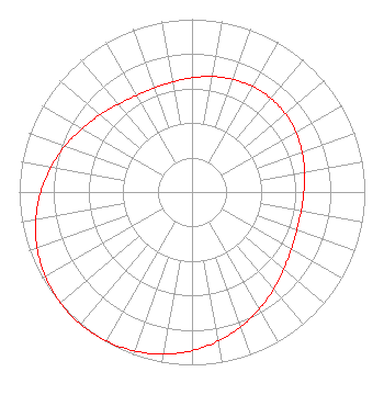 | ||||||||||||||||||
| Azimuth | Ratio | Azimuth | Ratio | Azimuth | Ratio | Azimuth | Ratio | ||||||||||||
| 0 | 0.661 | 10 | 0.679 | 20 | 0.694 | 30 | 0.705 | ||||||||||||
| 40 | 0.709 | 50 | 0.705 | 60 | 0.694 | 70 | 0.678 | ||||||||||||
| 80 | 0.661 | 90 | 0.647 | 100 | 0.641 | 110 | 0.645 | ||||||||||||
| 120 | 0.663 | 130 | 0.694 | 140 | 0.734 | 150 | 0.781 | ||||||||||||
| 160 | 0.829 | 170 | 0.876 | 180 | 0.918 | 190 | 0.953 | ||||||||||||
| 200 | 0.979 | 210 | 0.995 | 220 | 1.000 | 230 | 0.995 | ||||||||||||
| 240 | 0.979 | 250 | 0.953 | 260 | 0.918 | 270 | 0.876 | ||||||||||||
| 280 | 0.829 | 290 | 0.781 | 300 | 0.734 | 310 | 0.694 | ||||||||||||
| 320 | 0.663 | 330 | 0.645 | 340 | 0.641 | 350 | 0.647 | ||||||||||||
Structure Registration Number 1029017 Structure Type: GTOWER Registered To: Gray Media Group, Inc. Structure Address: 12544 Highway 20 Youngstown, FL County Name: Bay County ASR Issued: 09/09/2020 Date Built: 01/01/1962 Site Elevation: 42.1 m (138 ft.) Structure Height: 247.5 m (812 ft.) Height Overall: 247.5 m (812 ft.) Overall Height AMSL: 289.6 m (950 ft.) FAA Determination: 03/07/2018 FAA Study #: 2018-ASO-3400-OE FAA Circular #: 70/7460-1L Paint & Light FAA Chapters: 4, 7, 12 Removed expiration date from determination. Scenario 1./jjs/case#635066 30-26-00.0 N 85-24-51.0 W (NAD 83) 30-25-59.3 N 85-24-51.3 W (Converted to NAD 27) |
3111 Bel Air Dr. #25d Las Vegas, NV 89109 Phone: 702-738-8376 Limited Liability Company | Title: Managing Member Date: 03/06/2024 Application Certifier Lvnv Broadcasting Company Llc 3111 Bel Air Dr. #25d Las Vegas, NV 89109 Applicant Dan J Alpert The Law Office Of Dan J. Alpert 2120 21st Rd. N Arlington, VA 22201 Legal Counsel Erik C Swanson, PE Hatfield & Dawson 9500 Greenwood Ave N Seattle, WA 98103 Consulting Engineer | |||||||||||||||||