
FCCInfo.com
A Service of Cavell, Mertz & Associates, Inc.
(855) FCC-INFO
|
|
KPJR-TV from 08/21/2007 |
Post-repack Channel 17 Virtual Channel 38 |
|
||||||||||||||||
|
|
Repacking Information: Pre-Repack Channel: 38 Post-Repack Channel: 17 Post-Repack ERP: 633 kW Phase: 2 Completion Deadline: 4/12/2019 Upstream/Downstream Dependencies Other Linked Stations Find nearby TV Facilities Status: Application Application Accepted: 03/12/2024 License Expires: 09/17/2024 File Number: -0000240737 FCC Website Links: LMS Facility Details This Application Other KPJR-TV Applications Including Superseded Applications Mailing Address Correspondence for KPJR-TV Correspondence related to application -0000240737 Service Contour - Open Street Map or USGS Map (41 dBu) Service Contour - KML / Google Earth (41 dBu) Public Inspection Files Rabbit Ears Info Search for KPJR-TV Site Location: 40-05-57.0 N 104-54-03.2 W (NAD 83) Site Location: 40-05-57.1 N 104-54-01.3 W (Converted to NAD 27) ERP: 1000 kW Polarization: Horizontally polarized HAAT: 302.6 m (993 ft.) Electrical Beam Tilt: 1.0 degree R/C AGL: 271.3 m (890 ft.) R/C AMSL: 1822.7 m (5980 ft.) Site Elevation: 1551.4 m. (5090 ft.) Height Overall*: 352.9 m (1158 ft.) (* As Filed In This Application, may differ from ASR Data, Below.) Directional Antenna - Antenna Make/Model: DIELECTRIC TFU-24JSC/VP-R C170 Antenna ID: 1011552 Polarization: Horizontally polarized | ||||||||||||||||||
| Antenna Data for Antenna Id: 1011552 KPJR-TV DT File: -0000240737 DIELECTRIC - TFU-24JSC/VP-R C170 Service: DT Standard Pattern: N | 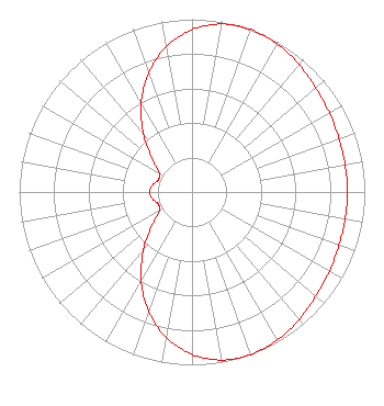 | ||||||||||||||||||
| Azimuth | Ratio | Azimuth | Ratio | Azimuth | Ratio | Azimuth | Ratio | ||||||||||||
| 0 | 0.940 | 10 | 0.987 | 20 | 1.000 | 30 | 0.988 | ||||||||||||
| 40 | 0.963 | 50 | 0.936 | 60 | 0.917 | 70 | 0.905 | ||||||||||||
| 80 | 0.900 | 90 | 0.899 | 100 | 0.900 | 110 | 0.905 | ||||||||||||
| 120 | 0.917 | 130 | 0.936 | 140 | 0.963 | 150 | 0.988 | ||||||||||||
| 160 | 1.000 | 170 | 0.987 | 180 | 0.940 | 190 | 0.854 | ||||||||||||
| 200 | 0.733 | 210 | 0.588 | 220 | 0.437 | 230 | 0.302 | ||||||||||||
| 240 | 0.218 | 250 | 0.207 | 260 | 0.232 | 270 | 0.245 | ||||||||||||
| 280 | 0.232 | 290 | 0.207 | 300 | 0.218 | 310 | 0.302 | ||||||||||||
| 320 | 0.437 | 330 | 0.588 | 340 | 0.733 | 350 | 0.854 | ||||||||||||
Structure Registration Number 1254146 Structure Type: GTOWER Registered To: American Towers LLC Structure Address: 6870 Weld County Rd 17 (282680) Fort Lupton, CO County Name: Weld County ASR Issued: 08/09/2021 Date Built: 07/14/2016 Site Elevation: 1551.4 m (5090 ft.) Structure Height: 306.9 m (1007 ft.) Height Overall: 352.9 m (1158 ft.) Overall Height AMSL: 1904.3 m (6248 ft.) FAA Determination: 08/05/2021 FAA Study #: 2021-ANM-5069-OE FAA Circular #: 70/7460-1K Paint & Light FAA Chapters: 4, 9, 12 PRIOR STUDY 2016-ANM-500-OE 40-05-57.0 N 104-54-03.2 W (NAD 83) 40-05-57.1 N 104-54-01.3 W (Converted to NAD 27) |
13600 Heritage Parkway Suite 200 Fort Worth, TX 76177 Phone: 855-826-2255 Not-for-Profit | Title: Assistant Secretary Date: 03/12/2024 Application Certifier TRINITY BROADCASTING NETWORKS Trinity Broadcasting Of Texas, Inc. 13600 Heritage Parkway Suite 200 Fort Worth, TX 76177 Applicant Kyle T. Fisher Smith & Fisher 4791 Wintergreen Court Woodbridge, VA 22192 Broadcast Consultant Coby M May, Esq. Colby M. May, Esq., P.c. P. O. Box 15473 Washington, DC 20003 Attorney | |||||||||||||||||