
FCCInfo.com
A Service of Cavell, Mertz & Associates, Inc.
(855) FCC-INFO
|
|
KDKZ-LD from 02/22/2011 |
Virtual Channel 18 |
|
||||||||||||||||
|
|
Status: Construction Permit (Licensed And Silent) Application Accepted: 03/15/2024 KDKZ-LD CP Expires: 03/19/2027 File Number: -0000241068 FCC Website Links: LMS Facility Details This Application Other KDKZ-LD Applications Including Superseded Applications Mailing Address Correspondence for KDKZ-LD Correspondence related to application -0000241068 Service Contour - Open Street Map or USGS Map (51 dBu) Service Contour - KML / Google Earth (51 dBu) Rabbit Ears Info Search for KDKZ-LD Site Location: 38-13-10.0 N 90-35-44.0 W (NAD 83) Site Location: 38-13-09.8 N 90-35-43.5 W (Converted to NAD 27) ERP: 0.8 kW Polarization: Horizontally polarized Electrical Beam Tilt: 0.75 degrees R/C AGL: 32 m (105 ft.) R/C AMSL: 258.8 m (849 ft.) Emission Mask: Simple Site Elevation: 226.8 m. (744 ft.) Height Overall*: 397.8 m (1305 ft.) (* As Filed In This Application, may differ from ASR Data, Below.) Directional Antenna - Antenna Make/Model: ELTI TVPA 40/50 UHF Antenna ID: 1011562 Polarization: Horizontally polarized | ||||||||||||||||||
| Antenna Data for Antenna Id: 1011562 KDKZ-LD LD File: -0000241068 ELTI - TVPA 40/50 UHF Service: LD Standard Pattern: N | 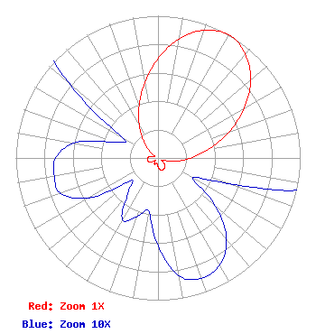 | ||||||||||||||||||
| Azimuth | Ratio | Azimuth | Ratio | Azimuth | Ratio | Azimuth | Ratio | ||||||||||||
| 0 | 0.700 | 10 | 0.851 | 20 | 0.955 | 30 | 1.000 | ||||||||||||
| 40 | 0.955 | 50 | 0.851 | 60 | 0.700 | 70 | 0.531 | ||||||||||||
| 80 | 0.367 | 90 | 0.232 | 100 | 0.132 | 110 | 0.052 | ||||||||||||
| 120 | 0.028 | 130 | 0.053 | 140 | 0.075 | 150 | 0.087 | ||||||||||||
| 160 | 0.090 | 170 | 0.084 | 180 | 0.062 | 190 | 0.038 | ||||||||||||
| 200 | 0.044 | 210 | 0.050 | 220 | 0.033 | 230 | 0.025 | ||||||||||||
| 240 | 0.056 | 250 | 0.073 | 260 | 0.074 | 270 | 0.072 | ||||||||||||
| 280 | 0.060 | 290 | 0.033 | 300 | 0.029 | 310 | 0.082 | ||||||||||||
| 320 | 0.158 | 330 | 0.263 | 340 | 0.389 | 350 | 0.537 | ||||||||||||
Structure Registration Number 1004576 Structure Type: TOWER Registered To: Subcarrier Communications Inc Structure Address: 2 Mi Sw Hillsboro, MO County Name: Jefferson County ASR Issued: 10/30/2018 Date Built: 01/01/1987 Site Elevation: 226.8 m (744 ft.) Structure Height: 396.8 m (1302 ft.) Height Overall: 397.8 m (1305 ft.) Overall Height AMSL: 624.6 m (2049 ft.) FAA Determination: 12/15/1986 FAA Study #: 86-ACE-0671-OE Paint & Light FAA Chapters: A1, B, E, H HIGH INTENSITY WHITE LIGHTS 38-13-10.0 N 90-35-44.0 W (NAD 83) 38-13-09.8 N 90-35-43.5 W (Converted to NAD 27) |
482 Harbor Drive North Indian Rocks Beach, FL 33785 Phone: 607-738-5623 Limited Liability Company | Title: President Date: 03/15/2024 Application Certifier Vision Communications, Llc 482 Harbor Drive North Indian Rocks Beach, FL 33785 Applicant Carl E Gluck Carl T Jones Corp 7901 Yarnwood Court Springfield, VA 22153 Technical Consultant Mark Denbo Smithwick & Belendiuk, P.c. 5028 Wisconsin Avenue, N.w. Suite 301 Washington, DC 20016 | |||||||||||||||||