
FCCInfo.com
A Service of Cavell, Mertz & Associates, Inc.
(855) FCC-INFO
|
|
WRJK-LD from 01/18/2013 WRJK-LD from 04/26/2001 WRJK-LD from 05/27/1987 |
|
|
||||||||||||||||
|
|
Status: License Application Accepted: 10/27/1999 License Expires: 12/01/2021 File Number: BLTT-19991020AAO Prefix Type: This is a license for a UHF translator FCC Website Links: LMS Facility Details This Application Other WRJK-LD Applications Including Superseded Applications Mailing Address Correspondence for WRJK-LD Correspondence related to application BLTT-19991020AAO Service Contour - Open Street Map or USGS Map (74 dBu) Service Contour - KML / Google Earth (74 dBu) Rabbit Ears Info Search for WRJK-LD Site Location: 42-08-13.7 N 87-58-57.2 W (NAD 83) Site Location: 42-08-13.6 N 87-58-56.9 W (Converted to NAD 27) ERP: 1.4 kW Polarization: Horizontally polarized Max Effective Radiated Power: 1.4 kW R/C AGL: 76 m (249 ft.) R/C AMSL: 292 m (958 ft.) Calculated Site Elevation: 216 m. (709 ft.) Height Overall*: 134.4 m (441 ft.) (* As Filed In This Application, may differ from ASR Data, Below.) Directional Antenna - Antenna Make/Model: Scala 4DR-16-2HW Antenna ID: 20732 Polarization: Horizontally polarized | ||||||||||||||||||
| Antenna Data for Antenna Id: 20732 WRJK-LD TX File: BLTT-19991020AAO Scala - 4DR-16-2HW Service: TX Standard Pattern: Y Pattern and Field Values Include a 135° Clockwise Rotation | 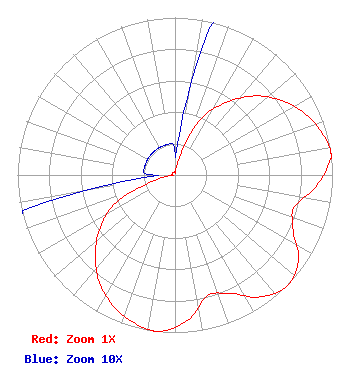 | ||||||||||||||||||
| Azimuth | Ratio | Azimuth | Ratio | Azimuth | Ratio | Azimuth | Ratio | ||||||||||||
| 5 | 0.020 | 15 | 0.130 | 25 | 0.395 | 35 | 0.560 | ||||||||||||
| 45 | 0.710 | 55 | 0.825 | 65 | 0.915 | 75 | 0.975 | ||||||||||||
| 82 | 1.000 | 85 | 0.983 | 95 | 0.895 | 105 | 0.784 | ||||||||||||
| 115 | 0.827 | 125 | 0.955 | 135 | 1.000 | 145 | 0.945 | ||||||||||||
| 155 | 0.830 | 165 | 0.795 | 175 | 0.925 | 185 | 0.995 | ||||||||||||
| 188 | 1.000 | 195 | 0.975 | 205 | 0.920 | 215 | 0.835 | ||||||||||||
| 225 | 0.715 | 235 | 0.580 | 245 | 0.410 | 255 | 0.135 | ||||||||||||
| 265 | 0.020 | 275 | 0.020 | 285 | 0.020 | 295 | 0.020 | ||||||||||||
| 305 | 0.020 | 315 | 0.020 | 325 | 0.020 | 335 | 0.020 | ||||||||||||
| 345 | 0.020 | 355 | 0.020 | ||||||||||||||||
Structure Registration Number 1054552 Structure Type: LTOWER Registered To: American Towers LLC Structure Address: 121 E. Boeger Drive (274580 / Arlington Heights Il) (274580) Arlington Heights, IL County Name: Cook County ASR Issued: 02/12/2024 Date Built: 12/21/1998 Site Elevation: 216.1 m (709 ft.) Structure Height: 115.8 m (380 ft.) Height Overall: 134.1 m (440 ft.) Overall Height AMSL: 350.2 m (1149 ft.) FAA Determination: 04/18/2023 FAA Study #: 2022-AGL-5522-OE FAA Circular #: 70/7460-1L Paint & Light FAA Chapters: 4, 8, 12 PRIOR STUDY 2018-AGL-17024-OE 42-08-13.6 N 87-58-57.2 W (NAD 83) 42-08-13.5 N 87-58-56.9 W (Converted to NAD 27) |
2383 Pruneridge Ave Suite 4 Santa Clara, CA 95050 Phone: 415-886-7284 Limited Liability Company | Date: 10/27/1999 Application Certifier TRINITY BROADCASTING NETWORK P.o.box C-11949 Santa Ana, CA 92711 Applicant ASSISTANT SECRETARY TERRENCE HICKEY | |||||||||||||||||