
FCCInfo.com
A Service of Cavell, Mertz & Associates, Inc.
(855) FCC-INFO
|
|
WTAS-LD from 11/25/1996 WTAS-LD from 01/04/1989 |
|
|
||||||||||||||||
|
|
Status: License Application Accepted: 10/01/2007 License Expires: 12/01/2021 File Number: BLTTL-20071001ACM Prefix Type: This is a license for a UHF LPTV station FCC Website Links: LMS Facility Details This Application Other WTAS-LD Applications Including Superseded Applications Mailing Address Correspondence for WTAS-LD Correspondence related to application BLTTL-20071001ACM Service Contour - Open Street Map or USGS Map (74 dBu) Service Contour - KML / Google Earth (74 dBu) Rabbit Ears Info Search for WTAS-LD Site Location: 42-58-05.0 N 88-11-20.1 W (NAD 83) Site Location: 42-58-05.0 N 88-11-19.8 W (Converted to NAD 27) ERP: 39.7 kW R/C AGL: 137 m (449 ft.) R/C AMSL: 455 m (1493 ft.) Site Elevation: 318 m. (1043 ft.) Height Overall*: 146 m (479 ft.) (* As Filed In This Application, may differ from ASR Data, Below.) Directional Antenna - Antenna Make/Model: MICRO COMMUNICATIONS INC 955516 Antenna ID: 20069 | ||||||||||||||||||
| Antenna Data for Antenna Id: 20069 WTAS-LD TX File: BLTTL-20071001ACM MICRO COMMUNICATIONS INC - 955516 Service: TX Standard Pattern: Y Pattern and Field Values Include a 70° Clockwise Rotation | 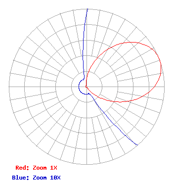 | ||||||||||||||||||
| Azimuth | Ratio | Azimuth | Ratio | Azimuth | Ratio | Azimuth | Ratio | ||||||||||||
| 0 | 0.094 | 10 | 0.218 | 20 | 0.378 | 30 | 0.556 | ||||||||||||
| 40 | 0.729 | 50 | 0.872 | 60 | 0.967 | 70 | 1.000 | ||||||||||||
| 80 | 0.967 | 90 | 0.872 | 100 | 0.729 | 110 | 0.556 | ||||||||||||
| 120 | 0.378 | 130 | 0.218 | 140 | 0.094 | 150 | 0.021 | ||||||||||||
| 160 | 0.010 | 170 | 0.010 | 180 | 0.010 | 190 | 0.010 | ||||||||||||
| 200 | 0.010 | 210 | 0.010 | 220 | 0.010 | 230 | 0.010 | ||||||||||||
| 240 | 0.010 | 250 | 0.010 | 260 | 0.010 | 270 | 0.010 | ||||||||||||
| 280 | 0.010 | 290 | 0.010 | 300 | 0.010 | 310 | 0.010 | ||||||||||||
| 320 | 0.010 | 330 | 0.010 | 340 | 0.010 | 350 | 0.021 | ||||||||||||
Structure Registration Number 1054380 [ASR Heights Differ from WTAS-LD Application] Structure Type: TOWER Registered To: Global Tower, LLC. through American Towers, LLC Structure Address: S42 W22080 Beeheim Rd Waukesha, WI County Name: Waukesha County ASR Issued: 08/29/2014 Date Built: 09/28/2006 Site Elevation: 318.1 m (1044 ft.) Structure Height: 149 m (489 ft.) Height Overall: 149 m (489 ft.) Overall Height AMSL: 467.1 m (1532 ft.) FAA Determination: 09/26/2009 FAA Study #: 2009-AGL-4567-OE FAA Circular #: 70/7460-1K Paint & Light FAA Chapters: 4, 8, 12 PRIOR STUDY 2009-AGL-3235-OE 42-58-05.0 N 88-11-20.1 W (NAD 83) 42-58-05.0 N 88-11-19.8 W (Converted to NAD 27) |
136 East Walker Milwaukee, WI 53204 Phone: 000-000-0000 Limited Liability Company | Date: 10/01/2007 Application Certifier WAUKESHA TOWER ASSOCIATES LIMITED PARTNERSHIP 4055 North 128th Street Brookfield, WI 53005 Applicant JOHN NEELY, ESQ. Miller And Neely, P.c. ROBERT G. TRUSCOTT 6558 Walters Dr. West Bend, WI 53090 CONSULTANT | |||||||||||||||||