
FCCInfo.com
A Service of Cavell, Mertz & Associates, Inc.
(855) FCC-INFO
|
|
K41KX-D from 08/05/2008 K41KX-D from 09/21/2005 |
|
|
||||||||||||||||
|
|
Status: License (Licensed And Silent) Application Accepted: 08/10/2009 License Expires: 02/01/2022 File Number: BLDTL-20090810ABU Prefix Type: This is BLDTL FCC Website Links: LMS Facility Details This Application Other K41KX-D Applications Including Superseded Applications Mailing Address Correspondence for K41KX-D Correspondence related to application BLDTL-20090810ABU Service Contour - Open Street Map or USGS Map (51 dBu) Service Contour - KML / Google Earth (51 dBu) Rabbit Ears Info Search for K41KX-D Site Location: 37-04-34.6 N 94-32-33.0 W (NAD 83) Site Location: 37-04-34.4 N 94-32-32.2 W (Converted to NAD 27) ERP: 15 kW R/C AGL: 120 m (394 ft.) R/C AMSL: 437 m (1434 ft.) Emission Mask: Stringent Site Elevation: 317 m. (1040 ft.) Height Overall*: 124 m (407 ft.) (* As Filed In This Application, may differ from ASR Data, Below.) Directional Antenna - Antenna Make/Model: Propagation System Inc PSILP8CRC CUSTOM Antenna ID: 92011 | ||||||||||||||||||
| Antenna Data for Antenna Id: 92011 K41KX-D LD File: BLDTL-20090810ABU Propagation System Inc - PSILP8CRC CUSTOM Service: LD Standard Pattern: Y Pattern and Field Values Include a 340° Clockwise Rotation | 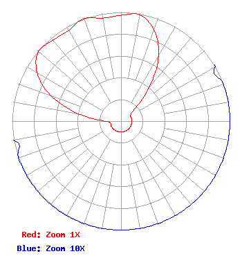 | ||||||||||||||||||
| Azimuth | Ratio | Azimuth | Ratio | Azimuth | Ratio | Azimuth | Ratio | ||||||||||||
| 0 | 0.970 | 10 | 0.990 | 20 | 0.890 | 30 | 0.690 | ||||||||||||
| 40 | 0.400 | 50 | 0.150 | 60 | 0.100 | 70 | 0.100 | ||||||||||||
| 80 | 0.100 | 90 | 0.100 | 100 | 0.100 | 110 | 0.100 | ||||||||||||
| 120 | 0.100 | 130 | 0.100 | 140 | 0.100 | 150 | 0.100 | ||||||||||||
| 160 | 0.100 | 170 | 0.100 | 180 | 0.100 | 190 | 0.100 | ||||||||||||
| 200 | 0.100 | 210 | 0.100 | 220 | 0.100 | 230 | 0.100 | ||||||||||||
| 240 | 0.100 | 250 | 0.100 | 260 | 0.100 | 270 | 0.150 | ||||||||||||
| 280 | 0.400 | 290 | 0.690 | 300 | 0.890 | 310 | 0.990 | ||||||||||||
| 320 | 0.970 | 330 | 0.960 | 340 | 1.000 | 350 | 0.960 | ||||||||||||
Structure Registration Number 1002748 Structure Type: Registered To: Zimmer Radio, Inc. Structure Address: 1309 S Monroe Joplin, MO County Name: Jasper County ASR Issued: 06/08/2022 Date Built: 01/01/1940 Site Elevation: 317 m (1040 ft.) Structure Height: 123.1 m (404 ft.) Height Overall: 124 m (407 ft.) Overall Height AMSL: 441 m (1447 ft.) FAA Determination: 02/25/2009 FAA Study #: 2009-ACE-60-OE Paint & Light FAA Chapters: 1, 3, 12, 21 37-04-34.6 N 94-32-33.0 W (NAD 83) 37-04-34.4 N 94-32-32.2 W (Converted to NAD 27) |
Hurst, TX 76054 Phone: 214-770-7770 Corporation | Date: 08/10/2009 Application Certifier EICB-TV EAST, LLC 406 Copeland Drive Cedar Hill, TX 75104 Applicant B. W. ST. CLAIR 2355 Ranch Drive Westminster, CO 80234 ENGINEERING CONSULTANT DR. RANDY WEISS Eicb-tv East, Llc | |||||||||||||||||