
FCCInfo.com
A Service of Cavell, Mertz & Associates, Inc.
(855) FCC-INFO
|
|
WGPS-LD from 12/13/2013 WGPS-LD from 05/03/1999 WGPS-LD from 06/21/1995 |
|
|
||||||||||||||||
|
|
Status: Construction Permit Application Accepted: 05/01/2014 WGPS-LD CP Expires: 02/01/2021 File Number: BPTTL-20140501ACL Prefix Type: This is a construction permit for a UHF LPTV station FCC Website Links: LMS Facility Details This Application Other WGPS-LD Applications Including Superseded Applications Mailing Address Correspondence for WGPS-LD Correspondence related to application BPTTL-20140501ACL Service Contour - Open Street Map or USGS Map (74 dBu) Service Contour - KML / Google Earth (74 dBu) Rabbit Ears Info Search for WGPS-LD Site Location: 26-26-55.4 N 81-48-53.7 W (NAD 83) Site Location: 26-26-54.1 N 81-48-54.4 W (Converted to NAD 27) ERP: 15 kW R/C AGL: 99 m (325 ft.) R/C AMSL: 102.1 m (335 ft.) Site Elevation: 3.1 m. (10 ft.) Height Overall*: 147.5 m (484 ft.) (* As Filed In This Application, may differ from ASR Data, Below.) Directional Antenna - Antenna Make/Model: DIELECTRIC DLP-8J Antenna ID: 118443 | ||||||||||||||||||
| Antenna Data for Antenna Id: 118443 WGPS-LD TX File: BPTTL-20140501ACL DIELECTRIC - DLP-8J Service: TX Standard Pattern: Y Pattern and Field Values Include a 300° Clockwise Rotation | 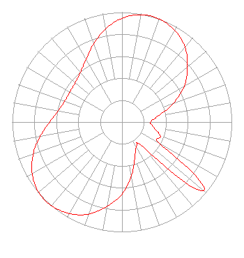 | ||||||||||||||||||
| Azimuth | Ratio | Azimuth | Ratio | Azimuth | Ratio | Azimuth | Ratio | ||||||||||||
| 0 | 0.945 | 10 | 0.992 | 20 | 0.997 | 30 | 0.962 | ||||||||||||
| 40 | 0.892 | 50 | 0.778 | 60 | 0.654 | 70 | 0.496 | ||||||||||||
| 80 | 0.343 | 90 | 0.260 | 100 | 0.298 | 110 | 0.371 | ||||||||||||
| 120 | 0.402 | 130 | 0.971 | 140 | 0.298 | 150 | 0.260 | ||||||||||||
| 160 | 0.343 | 170 | 0.496 | 180 | 0.654 | 190 | 0.778 | ||||||||||||
| 200 | 0.892 | 210 | 0.962 | 220 | 0.997 | 230 | 0.992 | ||||||||||||
| 240 | 0.945 | 250 | 0.861 | 260 | 0.756 | 270 | 0.658 | ||||||||||||
| 280 | 0.589 | 290 | 0.556 | 300 | 0.548 | 310 | 0.556 | ||||||||||||
| 320 | 0.589 | 330 | 0.658 | 340 | 0.756 | 350 | 0.861 | ||||||||||||
Structure Registration Number 1032129 Structure Type: TOWER Registered To: GTC Uno, LLC Structure Address: 20125 S Tamiami Trail Estero, FL County Name: Lee County ASR Issued: 12/27/2023 Date Built: 07/15/2010 Site Elevation: 3.1 m (10 ft.) Structure Height: 146.6 m (481 ft.) Height Overall: 147.5 m (484 ft.) Overall Height AMSL: 150.6 m (494 ft.) FAA Determination: 07/12/2010 FAA Study #: 2010-ASO-3427-OE FAA Circular #: 70/7460-1K Paint & Light FAA Chapters: 4, 8, 12 PRIOR STUDY 2010-ASO-2611-OE 26-26-55.4 N 81-48-53.7 W (NAD 83) 26-26-54.1 N 81-48-54.4 W (Converted to NAD 27) |
295 Madison Avenue, 12th Floor New York, NY 10017 Phone: 954-606-5486 Corporation | Date: 05/01/2014 Application Certifier WGPS OF SOUTHWEST FLORIDA, LLC 17945 Porta Vecchio Way Unit 102 Naples, FL 34110 Applicant JAMES GALLAGHER 2398 Commercial Way Suite 226 Spring Hill, FL 34606 CONSULTANT KRISTINA BRUNI Bella Spectra Corporation 13762 W State Road 84 Suite 81 Davie, FL 33325 | |||||||||||||||||