
FCCInfo.com
A Service of Cavell, Mertz & Associates, Inc.
(855) FCC-INFO
|
|
W16CL-D from 08/15/2008 W16CL-D from 08/17/2005 |
|
|
||||||||||||||||
|
|
Status: License Application Accepted: 10/02/2008 License Expires: 02/01/2021 File Number: BLTTL-20081002AFT Prefix Type: This is a license for a UHF LPTV station FCC Website Links: LMS Facility Details This Application Other W16CL-D Applications Including Superseded Applications Mailing Address Correspondence for W16CL-D Correspondence related to application BLTTL-20081002AFT Service Contour - Open Street Map or USGS Map (74 dBu) Service Contour - KML / Google Earth (74 dBu) Rabbit Ears Info Search for W16CL-D Site Location: 24-33-19.8 N 81-48-04.5 W (NAD 83) Site Location: 24-33-18.3 N 81-48-05.2 W (Converted to NAD 27) ERP: 1.8 kW R/C AGL: 46 m (151 ft.) R/C AMSL: 49.4 m (162 ft.) Site Elevation: 3.4 m. (11 ft.) Height Overall*: 61 m (200 ft.) (* As Filed In This Application, may differ from ASR Data, Below.) Directional Antenna - Antenna Make/Model: Scala PR-450CU Antenna ID: 23500 | ||||||||||||||||||
| Antenna Data for Antenna Id: 23500 W16CL-D TX File: BLTTL-20081002AFT Scala - PR-450CU Service: TX Standard Pattern: Y Pattern and Field Values Include a 70° Clockwise Rotation | 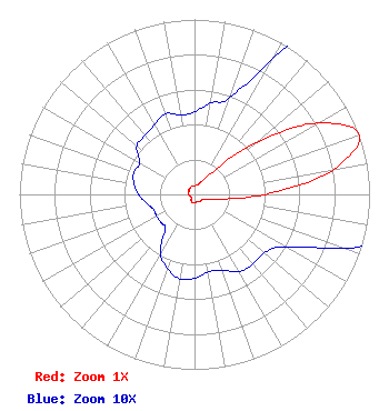 | ||||||||||||||||||
| Azimuth | Ratio | Azimuth | Ratio | Azimuth | Ratio | Azimuth | Ratio | ||||||||||||
| 0 | 0.047 | 10 | 0.053 | 20 | 0.059 | 30 | 0.090 | ||||||||||||
| 40 | 0.180 | 50 | 0.460 | 60 | 0.815 | 70 | 1.000 | ||||||||||||
| 80 | 0.800 | 90 | 0.400 | 100 | 0.150 | 110 | 0.090 | ||||||||||||
| 120 | 0.060 | 130 | 0.052 | 140 | 0.052 | 150 | 0.051 | ||||||||||||
| 160 | 0.046 | 170 | 0.045 | 180 | 0.048 | 190 | 0.049 | ||||||||||||
| 200 | 0.045 | 210 | 0.039 | 220 | 0.026 | 230 | 0.025 | ||||||||||||
| 240 | 0.025 | 250 | 0.025 | 260 | 0.028 | 270 | 0.032 | ||||||||||||
| 280 | 0.035 | 290 | 0.037 | 300 | 0.036 | 310 | 0.043 | ||||||||||||
| 320 | 0.044 | 330 | 0.046 | 340 | 0.049 | 350 | 0.046 | ||||||||||||
Structure Registration Number 1030880 Structure Type: POLE Registered To: ADOLPHUS WARFIELD INC Structure Address: 527 Southard St Key West, FL County Name: Monroe County ASR Issued: 07/11/2003 Date Built: 02/25/2004 Site Elevation: 3.4 m (11 ft.) Structure Height: 61 m (200 ft.) Height Overall: 61 m (200 ft.) Overall Height AMSL: 64.4 m (211 ft.) FAA Determination: 06/20/2003 FAA Study #: 2003-ASO-2664-OE Paint & Light FAA Chapters: NONE Removed expiration date from determination. Scenario 1./jjs/case#635066 24-33-19.8 N 81-48-04.5 W (NAD 83) 24-33-18.3 N 81-48-05.2 W (Converted to NAD 27) |
1498 Buford Hwy Ste C 275 Sugar Hill, GA 30518 Phone: 770-771-1644 Corporation | Date: 10/02/2008 Application Certifier PRISM BROADCASTING NETWORK, INC. 7742 Spalding Dr. Suite 475 Norcross, GA 30092 Applicant B. W. ST. CLAIR 2355 Ranch Drive Westminster, CO 80234 ENGINEERING CONSULTANT PRISM BROADCASTING NETWORK, INC. | |||||||||||||||||