|
|
Antenna Structure Registration 1063315 |
 |
Registration Info | Registration Number: 1063315 |
| File Number: A1381473 |
| FAA Study: 2025-ASW-9285-OE |
| FAA Issue Date: 03/26/2026 |
| Status: Constructed |
| Date Constructed: 12/07/1998 |
| NEPA: N |
Structure Info
| Structure Type: GTOWER |
| Structure Coordinates: 35-31-19.5 N 98-52-21.5 W (NAD 83) |
| Structure Coordinates: 35-31-19.3 N 98-52-20.2 W (Converted to NAD 27) |
| Structure Address: 23080 E 1030 Rd. (chapel Hill Ok #75230) |
| Structure City: Clinton, OK |
| Structure County: Custer County |
| Painting & Lighting Info |
FAA Circular #: 70/7460-1J |
FAA Chapters: 4, 8, 13 |
Remarks: OM&L to remain the same as prior study = A MED-DUAL SYSTEM |
Remarks: PRIOR STUDY 2010-ASW-3444-OE |
Remarks: OM&L to remain the same as prior study = A MED-DUAL SYSTEM |
Remarks: PRIOR STUDY 2010-ASW-3444-OE |
| Elevation Info |
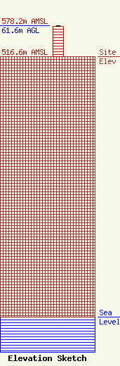
Site Elevation: 516.6 meters (1695 ft) |
| Height of Structure: 60.9 meters (200 feet) |
| Overall Height Above Ground: 61.6 meters (202 feet) |
| Overall Height Above Mean Sea Level: 578.2 meters (1897 feet) |
| Owner Info | American Towers LLC
10 Presidential Way
Woburn, MA 01801
(781) 926-4500
faa-fcc@americantower.com |
| Contact Info | American Towers LLC
10 Presidential Way
Woburn, MA 01801
(781) 926-4500
faa-fcc@americantower.com |
