|
|
Antenna Structure Registration 1226436 |
 |
Registration Info | Registration Number: 1226436 |
| File Number: A1181466 |
| FAA Study: 00-ACE-1355-OE |
| FAA Issue Date: 08/17/2000 |
| Status: Constructed |
| Date Constructed: 07/21/2000 |
| FAA EMI: N |
| NEPA: N |
Structure Info
| Structure Type: TOWER |
| Structure Coordinates: 37-53-37.0 N 101-56-47.9 W (NAD 83) |
| Structure Coordinates: 37-53-37.0 N 101-56-46.3 W (Converted to NAD 27) |
| Structure Address: Road Ff |
| Structure City: Syracuse, KS |
| Structure County: Hamilton County |
| Painting & Lighting Info |
FAA Circular #: 70/7460-1K |
FAA Chapters: 4, 8, 12 |
Remarks: PRIOR STUDY 93-ACE-0117-OE |
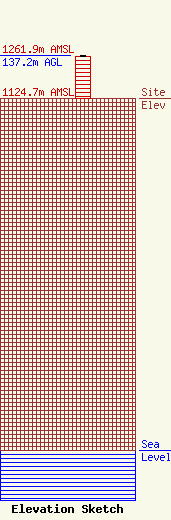
| Elevation Info |
Site Elevation: 1124.7 meters (3690 ft) |
| Height of Structure: 134.1 meters (440 feet) |
| Overall Height Above Ground: 137.2 meters (450 feet) |
| Overall Height Above Mean Sea Level: 1261.9 meters (4140 feet) |
| Owner Info | American Towers LLC
10 Presidential Way
Woburn, MA 01801
(781) 926-4500
faa-fcc@americantower.com |
| Contact Info | American Towers LLC
10 Presidential Way
Woburn, MA 01801
(781) 926-4500
faa-fcc@americantower.com |
