|
|
Antenna Structure Registration 1032768 |
 |
Registration Info | Registration Number: 1032768 |
| File Number: A1105554 |
| FAA Study: 97-ACE-1137-OE |
| Status: Constructed |
| Date Constructed: 07/01/1963 |
| NEPA: N |
Structure Info
| Structure Type: TOWER |
| Structure Coordinates: 38-57-29.0 N 99-21-8.0 W (NAD 83) |
| Structure Coordinates: 38-57-29.0 N 99-21-06.6 W (Converted to NAD 27) |
| Structure Address: 5.5 Mi N 1 Mi W |
| Structure City: Hays, KS |
| Structure County: Ellis County |
| Painting & Lighting Info |
FAA Circular #: 70/7460-1J |
FAA Chapters: 4, 6, 13 |
| Elevation Info |
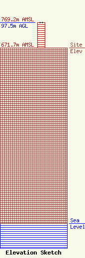
Site Elevation: 671.7 meters (2204 ft) |
| Height of Structure: 96 meters (315 feet) |
| Overall Height Above Ground: 97.5 meters (320 feet) |
| Overall Height Above Mean Sea Level: 769.2 meters (2524 feet) |
| Owner Info | Divine Mercy Radio, Inc.
108 E. 12th St., Suite 1
Hays, KS 67601
(785) 621-4110
donetta@dvmercy.com |
| Contact Info | Law Office of Dennis J. Kelly
41177
Washington, DC 20018-0577
Dennis Kelly
(202) 293-2300
dkellyfcclaw1@comcast.net |
