|
|
Antenna Structure Registration 1285904 |
 |
Registration Info | Registration Number: 1285904 |
| File Number: A0868364 |
| FAA Study: 2012-ANM-1300-OE |
| FAA Issue Date: 06/26/2012 |
| Status: Constructed |
| Date Constructed: 12/13/2013 |
| FAA EMI: N |
Structure Info
| Structure Type: LTOWER |
| Structure Coordinates: 43-20-44.9 N 114-47-33.7 W (NAD 83) |
| Structure Coordinates: 43-20-45.3 N 114-47-30.5 W (Converted to NAD 27) |
| Structure Address: 119 Willow Ave West |
| Structure City: Fairfield, ID |
| Structure County: Camas County |
| Painting & Lighting Info |
FAA Chapters: NONE |
Remarks: PRIOR STUDY 2010-ANM-920-OE |
| Elevation Info |
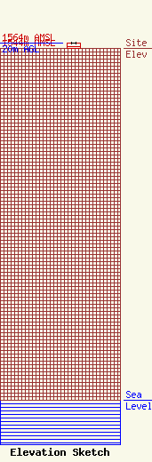
Site Elevation: 1544 meters (5066 ft) |
| Height of Structure: 20 meters (66 feet) |
| Overall Height Above Ground: 20 meters (66 feet) |
| Overall Height Above Mean Sea Level: 1564 meters (5131 feet) |
| Owner Info | State Of Idaho
700 S. Stratford Drive, Bldg #6
83720
Boise, ID 83720-0076
(208) 288-4000
FCCnotices@bhs.idaho.gov |
| Contact Info | State of Idaho
700 S. Stratford Drive, Bldg #6
83720
Boise, ID 83720-0076
Darrin Terry
(208) 288-4000
FCCnotices@bhs.idaho.gov |
