|
|
Antenna Structure Registration 1022695 |
 |
Registration Info | Registration Number: 1022695 |
| File Number: A0941110 |
| Status: Constructed |
| Date Constructed: 01/01/1968 |
| NEPA: N |
Structure Info
| Structure Type: TOWER |
| Structure Coordinates: 46-19-20.0 N 94-9-45.0 W (NAD 83) |
| Structure Coordinates: 46-19-20.1 N 94-09-44.0 W (Converted to NAD 27) |
| Structure Address: 2 Km E Jct Cty 45 & 117 On Twp Rd .8 Kms |
| Structure City: Brainerd, MN |
| Structure County: Crow Wing County |
| Painting & Lighting Info |
FCC Paragraph(s): 1, 3, 12, 21 |
| Elevation Info |
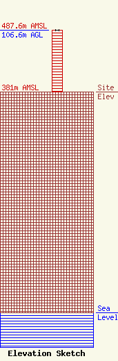
Site Elevation: 381 meters (1250 ft) |
| Height of Structure: 106.6 meters (350 feet) |
| Overall Height Above Ground: 106.6 meters (350 feet) |
| Overall Height Above Mean Sea Level: 487.6 meters (1600 feet) |
| Owner Info | Kevtel Corporation
3648 Keen Avenue
10
Mountville, PA 17554
(717) 342-9031
kevin@kevtel.com |
