|
|
Antenna Structure Registration 1016624 |
 |
Registration Info | Registration Number: 1016624 |
| File Number: A1212696 |
| FAA Study: 2022-ACE-111-OE |
| FAA Issue Date: 03/04/2022 |
| Status: Constructed |
| Date Constructed: 07/04/1988 |
| NEPA: N |
Structure Info
| Structure Type: LTOWER |
| Structure Coordinates: 42-1-17.9 N 93-34-57.8 W (NAD 83) |
| Structure Coordinates: 42-01-17.9 N 93-34-57.0 W (Converted to NAD 27) |
| Structure Address: 2220 E Lincoln Way |
| Structure City: Ames, IA |
| Structure County: Story County |
| Painting & Lighting Info |
FAA Circular #: 70/7460-1J |
FAA Chapters: 4, 6, 13 |
Remarks: OM&L to remain the same as prior study = 24-HR MED-STROBES |
Remarks: PRIOR STUDY 1998-ACE-369-OE |
Remarks: OM&L to remain the same as prior study = 24-HR MED-STROBES |
Remarks: PRIOR STUDY 1998-ACE-369-OE |
| Elevation Info |
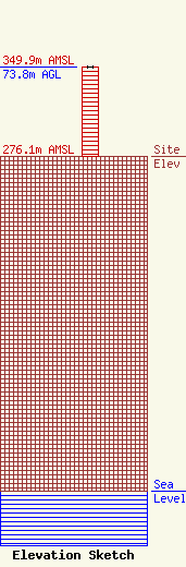
Site Elevation: 276.1 meters (906 ft) |
| Height of Structure: 73.8 meters (242 feet) |
| Overall Height Above Ground: 73.8 meters (242 feet) |
| Overall Height Above Mean Sea Level: 349.9 meters (1148 feet) |
| Owner Info | ELECTRONIC ENGINEERING CO
1100 KEO WAY
DES MOINES, IA 50309
(515) 283-1100
mclark@connectingyou.com |
| Contact Info | Welch Law
1025 Connecticut Ave NW
Washington, DC 20036
Timothy Welch
(202) 857-1470
welchlaw@earthlink.net |
